Grove City, Minnesota
Grove City | |
|---|---|
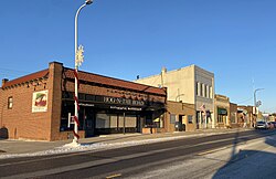 Atlantic Avenue businesses | |
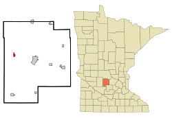 Location of Grove City within Meeker County, Minnesota | |
| Coordinates: 45°8′58″N 94°40′53″W / 45.14944°N 94.68139°W | |
| Country | United States |
| State | Minnesota |
| County | Meeker |
| Area | |
| • Total | 0.73 sq mi (1.88 km2) |
| • Land | 0.68 sq mi (1.75 km2) |
| • Water | 0.05 sq mi (0.13 km2) |
| Elevation | 1,191 ft (363 m) |
| Population | |
| • Total | 635 |
| • Estimate (2019)[3] | 619 |
| • Density | 915.68/sq mi (353.62/km2) |
| Time zone | UTC-6 (Central (CST)) |
| • Summer (DST) | UTC-5 (CDT) |
| ZIP code | 56243 |
| Area code(s) | 320 |
| FIPS code | 27-26126[4] |
| GNIS feature ID | 0644499[5] |

Grove City is a city in Meeker County, Minnesota, United States. The population was 635 at the 2010 census.[6]
History[]
Grove City was incorporated in 1878.[7] A post office called Grove City has been in operation since 1879.[8]
Geography[]
According to the United States Census Bureau, the city has a total area of 0.74 square miles (1.92 km2), of which 0.69 square miles (1.79 km2) is land and 0.05 square miles (0.13 km2) is water.[9]
U.S. Highway 12 and Minnesota State Highway 4 are two of the main routes in the community.
Demographics[]
| Historical population | |||
|---|---|---|---|
| Census | Pop. | %± | |
| 1880 | 230 | — | |
| 1890 | 349 | 51.7% | |
| 1900 | 316 | −9.5% | |
| 1910 | 351 | 11.1% | |
| 1920 | 388 | 10.5% | |
| 1930 | 372 | −4.1% | |
| 1940 | 447 | 20.2% | |
| 1950 | 481 | 7.6% | |
| 1960 | 466 | −3.1% | |
| 1970 | 531 | 13.9% | |
| 1980 | 596 | 12.2% | |
| 1990 | 547 | −8.2% | |
| 2000 | 608 | 11.2% | |
| 2010 | 635 | 4.4% | |
| 2019 (est.) | 619 | [3] | −2.5% |
| U.S. Decennial Census[10] | |||
2010 census[]
As of the census[2] of 2010, there were 635 people, 268 households, and 169 families living in the city. The population density was 920.3 inhabitants per square mile (355.3/km2). There were 291 housing units at an average density of 421.7 per square mile (162.8/km2). The racial makeup of the city was 97.0% White, 0.9% African American, 0.2% Native American, 0.3% Asian, 0.2% from other races, and 1.4% from two or more races. Hispanic or Latino of any race were 2.8% of the population.
There were 268 households, of which 31.7% had children under the age of 18 living with them, 44.0% were married couples living together, 11.6% had a female householder with no husband present, 7.5% had a male householder with no wife present, and 36.9% were non-families. 31.3% of all households were made up of individuals, and 11.5% had someone living alone who was 65 years of age or older. The average household size was 2.37 and the average family size was 2.92.
The median age in the city was 35.6 years. 26.8% of residents were under the age of 18; 7% were between the ages of 18 and 24; 26% were from 25 to 44; 24.2% were from 45 to 64; and 16.2% were 65 years of age or older. The gender makeup of the city was 47.6% male and 52.4% female.
2000 census[]
As of the census[4] of 2000, there were 608 people, 257 households, and 160 families living in the city. The population density was 951.8 people per square mile (366.8/km2). There were 271 housing units at an average density of 424.2 per square mile (163.5/km2). The racial makeup of the city was 97.86% White, 0.33% Asian, 0.33% from other races, and 1.48% from two or more races. Hispanic or Latino of any race were 2.96% of the population.
There were 257 households, out of which 30.4% had children under the age of 18 living with them, 46.7% were married couples living together, 12.8% had a female householder with no husband present, and 37.4% were non-families. 31.5% of all households were made up of individuals, and 14.4% had someone living alone who was 65 years of age or older. The average household size was 2.37 and the average family size was 2.98.
In the city, the population was spread out, with 28.5% under the age of 18, 10.0% from 18 to 24, 24.0% from 25 to 44, 20.4% from 45 to 64, and 17.1% who were 65 years of age or older. The median age was 36 years. For every 100 females, there were 88.8 males. For every 100 females age 18 and over, there were 86.7 males.
The median income for a household in the city was $29,313, and the median income for a family was $38,750. Males had a median income of $28,125 versus $20,417 for females. The per capita income for the city was $14,237. About 9.4% of families and 12.3% of the population were below the poverty line, including 10.3% of those under age 18 and 22.5% of those age 65 or over.
References[]
- ^ "2019 U.S. Gazetteer Files". United States Census Bureau. Retrieved July 26, 2020.
- ^ a b "U.S. Census website". United States Census Bureau. Retrieved 2012-11-13.
- ^ a b "Population and Housing Unit Estimates". United States Census Bureau. May 24, 2020. Retrieved May 27, 2020.
- ^ a b "U.S. Census website". United States Census Bureau. Retrieved 2008-01-31.
- ^ "US Board on Geographic Names". United States Geological Survey. 2007-10-25. Retrieved 2008-01-31.
- ^ "2010 Census Redistricting Data (Public Law 94-171) Summary File". American FactFinder. U.S. Census Bureau, 2010 Census. Retrieved 23 April 2011.[dead link]
- ^ Upham, Warren (1920). Minnesota Geographic Names: Their Origin and Historic Significance. Minnesota Historical Society. p. 340.
- ^ "Meeker County". Jim Forte Postal History. Retrieved 21 July 2015.
- ^ "US Gazetteer files 2010". United States Census Bureau. Archived from the original on 2012-01-25. Retrieved 2012-11-13.
- ^ "Census of Population and Housing". Census.gov. Retrieved June 4, 2015.
Municipalities and communities of Meeker County, Minnesota, United States | ||
|---|---|---|
| Cities |  | |
| Townships | ||
| Unincorporated communities | ||
| Footnotes | ‡This populated place also has portions in an adjacent county or counties | |
| ||
Coordinates: 45°09′02″N 94°40′59″W / 45.15056°N 94.68306°W
- Cities in Minnesota
- Cities in Meeker County, Minnesota