Forgan, Oklahoma
Forgan, Oklahoma | |
|---|---|
 Location in Beaver County and state of Oklahoma. | |
| Coordinates: 36°54′27″N 100°32′21″W / 36.90750°N 100.53917°WCoordinates: 36°54′27″N 100°32′21″W / 36.90750°N 100.53917°W | |
| Country | United States |
| State | Oklahoma |
| County | Beaver |
| Area | |
| • Total | 0.38 sq mi (0.98 km2) |
| • Land | 0.38 sq mi (0.98 km2) |
| • Water | 0.00 sq mi (0.00 km2) |
| Elevation | 2,592 ft (790 m) |
| Population | |
| • Total | 547 |
| • Estimate (2019)[3] | 529 |
| • Density | 1,395.78/sq mi (538.89/km2) |
| Time zone | UTC-6 (Central (CST)) |
| • Summer (DST) | UTC-5 (CDT) |
| ZIP code | 73938 |
| Area code(s) | 580 |
| FIPS code | 40-26900[4] |
| GNIS feature ID | 1092944[5] |

Forgan is a town in Beaver County, Oklahoma, United States. The population was 547 at the 2010 census.[2]
History[]
The town name honors James B. Forgan, a Chicago banker and financier.[6] L. B. Tooker established the first newspaper, the Forgan Enterprise, on June 6, 1912. A total of fifty-three businesses and four medical doctors were in the town at that time. As the town was located in a wheat-producing area, grain elevators were built to store wheat prior to shipment. The population dropped to 428 in 1940 after an exodus due to the Dust Bowl.[6]
From 1912 to 1973, Forgan was the northern terminus of the defunct Wichita Falls and Northwestern Railway (WF&NW), one of the and properties which linked the town through Altus, Oklahoma to Wichita Falls, Texas. The town was also the initial destination of the Beaver, Meade and Englewood Railroad (BM&E), arriving in 1915 to connect to the WF&NW.[7] The BM&E was abandoned in 1972;[8] and, in 1973, the WF&NW was cut back to Altus, with the northern route from Altus to Forgan being abandoned.[9]
At the turn of the twenty-first century the economy was based on wheat and milo farming, ranching, the oil and gas industry, and corporate hog farms.[6]
Geography[]
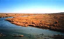
Forgan is located at 36°54′27″N 100°32′21″W / 36.90750°N 100.53917°W (36.907505, -100.539253).[10] Forgan lies between the Cimarron and Beaver rivers. According to the United States Census Bureau, the town has a total area of 0.4 square miles (1.0 km2), all land.
Demographics[]
| Historical population | |||
|---|---|---|---|
| Census | Pop. | %± | |
| 1920 | 582 | — | |
| 1930 | 605 | 4.0% | |
| 1940 | 428 | −29.3% | |
| 1950 | 410 | −4.2% | |
| 1960 | 532 | 29.8% | |
| 1970 | 496 | −6.8% | |
| 1980 | 611 | 23.2% | |
| 1990 | 489 | −20.0% | |
| 2000 | 532 | 8.8% | |
| 2010 | 547 | 2.8% | |
| 2019 (est.) | 529 | [3] | −3.3% |
| U.S. Decennial Census | |||
As of the 2010 United States Census, there were 547 people living in the town.[2] The population density was 1,400 people per square mile (550/km2). There were 239 housing units at an average density of 645 per square mile (252/km2). The racial makeup of the town was 89.47% White, 0.19% Native American, 0.38% Asian, 6.77% from other races, and 3.20% from two or more races. Hispanic or Latino of any race were 14.10% of the population.
There were 197 households, out of which 37.1% had children under the age of 18 living with them, 57.9% were married couples living together, 12.2% had a female householder with no husband present, and 27.4% were non-families. 25.4% of all households were made up of individuals, and 16.2% had someone living alone who was 65 years of age or older. The average household size was 2.70 and the average family size was 3.22.
In the town, the population was spread out, with 33.3% under the age of 18, 6.4% from 18 to 24, 27.8% from 25 to 44, 21.4% from 45 to 64, and 11.1% who were 65 years of age or older. The median age was 33 years. For every 100 females, there were 96.3 males. For every 100 females age 18 and over, there were 87.8 males.
The median income for a household in the town was $26,739, and the median income for a family was $29,167. Males had a median income of $25,000 versus $18,409 for females. The per capita income for the town was $13,250. About 17.6% of families and 17.9% of the population were below the poverty line, including 24.4% of those under age 18 and 7.1% of those age 65 or over.
References[]
- ^ "2019 U.S. Gazetteer Files". United States Census Bureau. Retrieved July 28, 2020.
- ^ a b c "2010 City Population and Housing Occupancy Status". U.S. Census Bureau. Retrieved October 18, 2013.[dead link]
- ^ a b "Population and Housing Unit Estimates". United States Census Bureau. May 24, 2020. Retrieved May 27, 2020.
- ^ "U.S. Census website". United States Census Bureau. Retrieved 2008-01-31.
- ^ "US Board on Geographic Names". United States Geological Survey. 2007-10-25. Retrieved 2008-01-31.
- ^ a b c Hodges, V. Pauline "Forgan," Encyclopedia of Oklahoma History and Culture, Oklahoma Historical Society, 2009. Accessed April 15, 2015.
- ^ "Construction Strategies of Railroads in the Oklahoma Panhandle". Donovan L. Hofsommer, Chronicles of Oklahoma, Vol. 58, No 1, Spring 1980, pp. 82-89. Retrieved December 6, 2021.
- ^ "The Beaver, Meade and Englewood Railroad". AbandonedRails.com. Retrieved December 6, 2021.
- ^ "Donovan L. Hofsommer, "The Wichita Falls and Northwestern Railway"". tshaonline.org. Retrieved April 21, 2013.
- ^ "US Gazetteer files: 2010, 2000, and 1990". United States Census Bureau. 2011-02-12. Retrieved 2011-04-23.
External links[]
- Hodges, V. Pauline. "Forgan," Encyclopedia of Oklahoma History and Culture, 2009. Accessed March 18, 2015.
Municipalities and communities of Beaver County, Oklahoma, United States | ||
|---|---|---|
| Towns |  | |
| CDPs | ||
| Other communities | ||
| ||
- Towns in Beaver County, Oklahoma
- Towns in Oklahoma
- Oklahoma Panhandle