Fort San Sebastian
| Fort San Sebastian | |
|---|---|
| Part of Dutch Gold Coast | |
 Fort San Sebastian in 1890. | |
 Fort San Sebastian | |
| Coordinates | 5°00′39″N 1°37′45″W / 5.010825°N 1.629199°W |
| Site history | |
| Built | 1523 |
| Garrison information | |
| Occupants | Portugal (1523-1642) Netherlands (1642-1872) |

Fort San Sebastian (Portuguese: Forte São Sebastião de Xama) located in Shama, Ghana is the third oldest fortification in Ghana.[1]
History[]
It was built by the Portuguese from 1520 to 1526 as a trading post in and captured by the Dutch West India Company in 1642. The original purpose of the fort was to serve as a deterrent to English sailors interfering in Shama trade.[1] The first black European university professor, Anton Wilhelm Amo, lies interred in the fort's graveyard. The fort was ceded with the entire Dutch Gold Coast to Britain in 1872.
During the time of the African Slave Trade, kidnapped Africans were imprisoned here while awaiting transport to North America.[2]
3D documentation with terrestrial laser scanning[]
The Zamani Project documented Fort San Sebastian in 2013, with terrestrial 3D laser scanning.[3] The data generated by the non-profit research group creates a permanent record that can be used for research, education, restoration, and conservation.[4][5][6]
A 3D model and a panorama tour, of Fort San Sebastian are available on www.zamaniproject.org. An animation of the 3D model is available here.
Gallery[]

Fort St Sebastian - close up

View of the fort from a boat
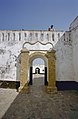
View from the gate to the front part of the fort, in the back the main gate with stairs to Shama

View of Shama from the fort
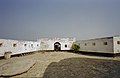
The front part of the fort


References[]
| Wikimedia Commons has media related to Fort San Sebastian (Ghana). |
- ^ Jump up to: a b "Fort San Sebastian, Shama (1526)". Ghana Museums and Monuments Board. Retrieved 10 April 2014.
- ^ Harrold, Darlene Clark Hine, William C. Hine, Stanley C (2014). The African-American odyssey : the combined volume (6th edition, combined volume. ed.). ISBN 0205940455.
- ^ "Site - Fort Saint Sebastian - Shama". zamaniproject.org. Retrieved 2019-10-07.
- ^ Rüther, Heinz. "An African heritage database, the virtual preservation of Africa's past" (PDF). www.isprs.org.
- ^ Rajan, Rahim S.; Rüther, Heinz (2007-05-30). "Building a Digital Library of Scholarly Resources from the Developing World: An Introduction to Aluka". African Arts. 40 (2): 1–7. doi:10.1162/afar.2007.40.2.1. ISSN 0001-9933.
- ^ Rüther, Heinz; Rajan, Rahim S. (December 2007). "Documenting African Sites: The Aluka Project". Journal of the Society of Architectural Historians. University of California Press. 66 (4): 437–443. doi:10.1525/jsah.2007.66.4.437. JSTOR 10.1525/jsah.2007.66.4.437.
Coordinates: 5°00′39″N 1°37′45″W / 5.010825°N 1.629199°W
| Authority control |
|
|---|
- Forts in Ghana
- Portuguese Gold Coast
- Dutch Gold Coast
- Western Region (Ghana)
- Buildings and structures completed in 1526
- 1526 establishments in Africa
- 1526 establishments in the Portuguese Empire
- 16th century in Ghana
- Castles in Ghana
- Portuguese Colonial architecture in Ghana
- Ghana geography stubs