Frontier, Saskatchewan
Frontier | |
|---|---|
Village | |
| Village of Frontier | |
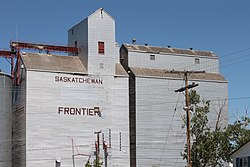 Ex. Saskatchewan Wheat Pool | |
 Frontier | |
| Coordinates: 49°11′59″N 108°34′01″W / 49.199738°N 108.56703°W | |
| Country | Canada |
| Province | Saskatchewan |
| Region | Southwest |
| Rural municipality | Frontier |
| Post office Founded | 1917 |
| Government | |
| • Type | Municipal |
| • Governing body | Frontier Village Council |
| • Mayor | Brady Berg |
| • Administrator | Barb Webber |
| • MLA | Doug Steele |
| • MP | Jeremy Patzer |
| Area | |
| • Total | 0.93 km2 (0.36 sq mi) |
| Population (2016) | |
| • Total | 372 |
| • Density | 399.5/km2 (1,035/sq mi) |
| Time zone | UTC-6 (CST) |
| Postal code | S0N 0W0 |
| Area code(s) | 306 |
| Highways | |
| Railways | Great Western Railway |
| Website | Village of Frontier |
| [1][2] | |


Frontier (2016 population: 372) is a village in the Canadian province of Saskatchewan within the Rural Municipality of Frontier No. 19 and Census Division No. 4. Frontier is on Highway 18 and is served by the Frontier Airport located (3.7 km) south of the village.
History[]
The Frontier post office was founded in 1917.[1] Frontier incorporated as a village on July 10, 1930.[3]
Demographics[]
In the 2016 Census of Population conducted by Statistics Canada, the Village of Frontier recorded a population of 372 living in 159 of its 186 total private dwellings, a 5.6% change from its 2011 population of 351. With a land area of 0.93 km2 (0.36 sq mi), it had a population density of 400.0/km2 (1,036.0/sq mi) in 2016.[6]
In the 2011 Census of Population, the Village of Frontier recorded a population of 351, a 24% change from its 2006 population of 283. With a land area of 0.93 km2 (0.36 sq mi), it had a population density of 377.4/km2 (977.5/sq mi) in 2011.[7]
Climate[]
| hideClimate data for Frontier | |||||||||||||
|---|---|---|---|---|---|---|---|---|---|---|---|---|---|
| Month | Jan | Feb | Mar | Apr | May | Jun | Jul | Aug | Sep | Oct | Nov | Dec | Year |
| Record high °C (°F) | 13 (55) |
19 (66) |
23.5 (74.3) |
30 (86) |
35 (95) |
37.5 (99.5) |
39.5 (103.1) |
38.5 (101.3) |
35 (95) |
32 (90) |
23.5 (74.3) |
13.5 (56.3) |
39.5 (103.1) |
| Average high °C (°F) | −5.2 (22.6) |
−2.3 (27.9) |
4.3 (39.7) |
13.0 (55.4) |
18.9 (66.0) |
23.3 (73.9) |
27.6 (81.7) |
27.0 (80.6) |
20.1 (68.2) |
12.4 (54.3) |
2.3 (36.1) |
−3.1 (26.4) |
11.5 (52.7) |
| Daily mean °C (°F) | −10.8 (12.6) |
−8.1 (17.4) |
−1.6 (29.1) |
6.0 (42.8) |
11.6 (52.9) |
16.2 (61.2) |
19.5 (67.1) |
18.8 (65.8) |
12.4 (54.3) |
5.6 (42.1) |
−3.1 (26.4) |
−8.6 (16.5) |
4.8 (40.6) |
| Average low °C (°F) | −16.4 (2.5) |
−13.9 (7.0) |
−7.4 (18.7) |
−1.1 (30.0) |
4.3 (39.7) |
9.1 (48.4) |
11.3 (52.3) |
10.5 (50.9) |
4.8 (40.6) |
−1.4 (29.5) |
−8.5 (16.7) |
−14.1 (6.6) |
−1.9 (28.6) |
| Record low °C (°F) | −41.5 (−42.7) |
−43 (−45) |
−35 (−31) |
−20.5 (−4.9) |
−10.0 (14.0) |
−2.0 (28.4) |
3.0 (37.4) |
−1.0 (30.2) |
−11.5 (11.3) |
−29.0 (−20.2) |
−35.0 (−31.0) |
−40.0 (−40.0) |
−43.0 (−45.4) |
| Average precipitation mm (inches) | 16.5 (0.65) |
12.3 (0.48) |
18.6 (0.73) |
23.0 (0.91) |
51.2 (2.02) |
76.9 (3.03) |
44.5 (1.75) |
41.8 (1.65) |
26.8 (1.06) |
16.2 (0.64) |
17.3 (0.68) |
13.9 (0.55) |
358.9 (14.13) |
| Source: Environment Canada[8] | |||||||||||||
Attractions[]
- Frontier & District Golf Course, a 9-hole facility located in Frontier, it also features all the hallmarks of Saskatchewan golf.
- Grasslands National Park, one of Canada's newer national parks and is located in southern Saskatchewan along the Montana border.
- Cypress Hills Interprovincial Park, an interprovincial park straddling the southern Alberta-Saskatchewan border, located southeast of Medicine Hat. It is Canada's only interprovincial park.
Education[]
Frontier School offers Kindergarten through grade 12 and is in the Chinook School Division.
Notable people[]
- Rhett Warrener, NHL player
- Braydon Coburn, NHL player
- David L. Anderson, former Conservative Member of Parliament
See also[]
- List of communities in Saskatchewan
- Villages of Saskatchewan
References[]
- ^ Jump up to: a b National Archives, Archivia Net. "Post Offices and Postmasters". Retrieved 22 April 2014.
- ^ Government of Saskatchewan, MRD Home. "Municipal Directory System". Archived from the original on 15 January 2016. Retrieved 2014-04-22.
- ^ "Urban Municipality Incorporations". Saskatchewan Ministry of Government Relations. Archived from the original on 15 October 2014. Retrieved 1 June 2020.
- ^ "Saskatchewan Census Population" (PDF). Saskatchewan Bureau of Statistics. Archived from the original (PDF) on 24 September 2015. Retrieved 31 May 2020.
- ^ "Saskatchewan Census Population". Saskatchewan Bureau of Statistics. Retrieved 31 May 2020.
- ^ "Population and dwelling counts, for Canada, provinces and territories, and census subdivisions (municipalities), 2016 and 2011 censuses – 100% data (Saskatchewan)". Statistics Canada. 8 February 2017. Retrieved 30 May 2020.
- ^ "Population and dwelling counts, for Canada, provinces and territories, and census subdivisions (municipalities), 2011 and 2006 censuses (Saskatchewan)". Statistics Canada. 3 June 2019. Retrieved 30 May 2020.
- ^ Environment Canada Canadian Climate Normals 1981–2010, accessed 27 July 2016
- Canada Flight Supplement. Effective 0901Z 16 July 2020 to 0901Z 10 September 2020.
| show Places adjacent to Frontier, Saskatchewan |
|---|
| show |
|---|
| show Division No. 4, Saskatchewan |
|---|

| show Authority control |
|---|
Coordinates: 49°11′56″N 108°34′01″W / 49.199°N 108.567°W
This article about a location in the Census Division No. 4 of Saskatchewan is a stub. You can help Wikipedia by . |
- Saskatchewan MLA templates
- Villages in Saskatchewan
- Frontier No. 19, Saskatchewan
- Division No. 4, Saskatchewan
- Saskatchewan geography stubs