Fuchū, Hiroshima
This article needs additional citations for verification. (January 2021) |
Fuchū
府中市 | |
|---|---|
 Flag  Emblem | |
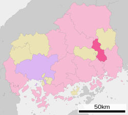
 Location of Fuchu in Hiroshima Prefecture | |
 Fuchū Location in Japan | |
| Coordinates: 34°33′54″N 133°14′31″E / 34.56500°N 133.24194°ECoordinates: 34°33′54″N 133°14′31″E / 34.56500°N 133.24194°E | |
| Country | Japan |
| Region | Chūgoku (San'yō) |
| Prefecture | Hiroshima Prefecture |
| Government | |
| • Mayor | Yoshikazu Itoh (since May 2002) |
| Area | |
| • Total | 195.71 km2 (75.56 sq mi) |
| Population (May 1, 2011) | |
| • Total | 43,932 |
| • Density | 224.47/km2 (581.4/sq mi) |
| Time zone | UTC+09:00 (JST) |
| City hall address | 315 Fukawacho, Fuchu-shi, Hiroshima-ken 726-8601 |
| Symbols | |
| Flower | Hydrangea |
| Tree | Cherry blossom |
Fuchū (府中市, Fuchū-shi) is a city located in Hiroshima Prefecture, Japan. It was originally the capital of the former Bingo Province. The city was founded on March 31, 1954. Fuchū, Tokyo became a city the following day.[citation needed] As of May 1, 2011, population data, the city has an estimated population of 43,932, with 17,602 households and a population density of 224.47 people per km². The total area is 195.71 km². On April 1, 2004, the town of Jōge (from Kōnu District) was merged into Fuchū.[1]
References[]
- ^ "Fuchu details". hiroshima-navi.or.jp. Retrieved 13 November 2019.
External links[]
| Wikimedia Commons has media related to Fuchu. |
- Fuchū City official website (in Japanese)
Categories:
- Cities in Hiroshima Prefecture
- Hiroshima geography stubs
