Shōbara, Hiroshima
This article includes a list of general references, but it remains largely unverified because it lacks sufficient corresponding inline citations. (May 2015) |
Shōbara
庄原市 | |
|---|---|
 | |
 Flag  Seal | |
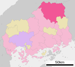 Location of Shōbara in Hiroshima Prefecture | |
 Shōbara Location in Japan | |
| Coordinates: 34°51′16″N 133°01′09″E / 34.85444°N 133.01917°ECoordinates: 34°51′16″N 133°01′09″E / 34.85444°N 133.01917°E | |
| Country | Japan |
| Region | Chūgoku (San'yō) |
| Prefecture | Hiroshima Prefecture |
| Government | |
| • Mayor | Suehiko Takiguchi (since December 2002) |
| Area | |
| • Total | 1,246.60 km2 (481.31 sq mi) |
| Population (May 31, 2018.) | |
| • Total | 35,870 |
| • Density | 29/km2 (75/sq mi) |
| Time zone | UTC+09:00 (JST) |
| City hall address | 1-10-1 Nakamoto-chō, Shōbara-shi, Hiroshima-ken 727-8501 |
| Website | www |
| Symbols | |
| Flower | Sakura, Azalea |
| Tree | Pine |

Shōbara (庄原市, Shōbara-shi) is a city located in northeastern Hiroshima Prefecture, Japan. The city was founded on March 31, 1954. As of May 31, 2018, the city has an estimated population of 35,870 and a population density of 28.77 persons per km².[1] The total area is 1,246.60 km².
On March 31, 2005, the towns of Hiwa, Kuchiwa, Saijō, Takano, and Tōjō (all from Hiba District), and the town of Sōryō (from Kōnu District) were merged into Shōbara. Hiba District and Kōnu District were both dissolved as a result of this merger.
References[]
- ^ "Official website of Shōbara City" (in Japanese). Japan: Shōbara City. Retrieved 17 May 2017.
External links[]
| Wikimedia Commons has media related to Shōbara, Hiroshima. |
- Shōbara City official website (in Japanese) (Translate to English: Google, Bing)
| show Authority control |
|---|
This Hiroshima Prefecture location article is a stub. You can help Wikipedia by . |
Categories:
- Cities in Hiroshima Prefecture
- Hiroshima geography stubs