Fului
Fului | |
|---|---|
Village | |
 Fului Location in West Bengal, India | |
| Coordinates: 22°54′40″N 87°33′25″E / 22.9111199°N 87.556972°ECoordinates: 22°54′40″N 87°33′25″E / 22.9111199°N 87.556972°E | |
| Country | |
| State | West Bengal |
| District | Hooghly |
| Population (2011) | |
| • Total | 5,984 |
| Languages | |
| • Official | Bengali, English |
| Time zone | UTC+5:30 (IST) |
| PIN | 712122 |
| Telephone/STD code | 03211 |
| Lok Sabha constituency | Arambagh |
| Vidhan Sabha constituency | Goghat |
| Website | hooghly |


Fului is a village in the Goghat II CD block in the Arambagh subdivision of Hooghly district in the Indian state of West Bengal.
Geography[]
M: municipal city/ town, R: rural/ urban centre, H: historical/ religious centre
Owing to space constraints in the small map, the actual locations in a larger map may vary slightly
Location[]
Fului is located at 22°54′40″N 87°33′25″E / 22.911199°N 87.55692°E
Area overview[]
The Arambagh subdivision, presented in the map alongside, is divided into two physiographic parts – the Dwarakeswar River being the dividing line. The western part is upland and rocky – it is extension of the terrain of neighbouring Bankura district. The eastern part is flat alluvial plain area. The railways, the roads and flood-control measures have had an impact on the area.[1] The area is overwhelmingly rural with 94.77% of the population living in rural areas and 5.23% of the population living in urban areas.[2]
Note: The map alongside presents some of the notable locations in the subdivision. All places marked in the map are linked in the larger full screen map.
Demographics[]
As per the 2011 Census of India, Fului had a total population of 5,984 of which 3,064 (51%) were males and 2,920 (49%) were females. Population in the age range 0–6 years was 638. The total number of literate persons in Fului was 4,173 (78.06% of the population over 6 years).[3]
Fului picture gallery[]
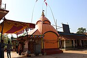
Fulleshwari temple, at chala, famous for its Gajan Utsab
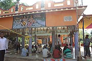
Natmadir


References[]
- ^ "District Census Handbook: Hugli, Series-20, Part XIIA" (PDF). Physiography, Page 17-19. Directorate of Census Operations, West Bengal, 2011. Retrieved 25 September 2020.
- ^ "District Statistical Handbook 2014 Hooghly". Table 2.2, 2.4(a). Department of Planning and Statistics, Government of West Bengal. Retrieved 25 September 2020.
- ^ "2011 Census – Primary Census Abstract Data Tables". West Bengal – District-wise. Registrar General and Census Commissioner, India. Retrieved 22 September 2020.
This article about a location in the Hooghly district of West Bengal is a stub. You can help Wikipedia by . |
- Villages in Hooghly district
- Hooghly district geography stubs