Jirat
This article needs additional citations for verification. (July 2013) |
Jirat | |
|---|---|
Census Town | |
   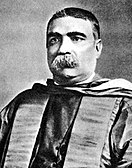 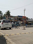 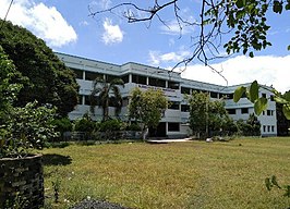 Clockwise from top: Jirat Railway Station, Headquarter of Balagarh Block, Jirat Bus Stand, Jirat College, Sir Ashutosh Mukherjee, Sri Sri Sarvamangala Kali Mata Temple | |
 Jirat Location in West Bengal, India | |
| Coordinates: 23°5′54″N 88°27′42″E / 23.09833°N 88.46167°ECoordinates: 23°5′54″N 88°27′42″E / 23.09833°N 88.46167°E | |
| Country | |
| State | |
| District | |
| Population (2011) | |
| • Total | 7,430 |
| Languages | |
| • Official | • Bengali, English |
| Time zone | UTC+5:30 (IST) |
| PIN | 712501 |
| Telephone Code | 03213 |
| Vehicle registration |
|
| Sex Ratio |
|
| Literacy | 79.01% |
| Lok Sabha Constituency | Hooghly |
| MP | Locket Chatterjee (BJP) |
| Vidhan Sabha Constituency | Balagarh |
| MLA | Manoranjan Byapari (AITC) |
| Highway | State Highway 6 (West Bengal) |
| Website | hooghly |
| Ancestral Town of Sir Ashutosh Mukherjee | |


Jirat is a census town located in Hooghly District in the Indian State of West Bengal. It is the administrative headquarter of Balagarh Block.
Geography[]
M: municipal city/ town, CT: census town, R: rural/ urban centre,
Owing to space constraints in the small map, the actual locations in a larger map may vary slightly
Location[]
Jirat is the Main Administrative Center (Sadar) of Balagarh Block. Balagarh BDO Office are located in Jirat. The Balagarh CD Block is mostly part of the Hooghly Flats, one of the three natural regions in the district composed of the flat alluvial plains that form a part of the Gangetic Delta. The region is a narrow strip of land along the 80 km long stretch of the Hooghly River, that forms the eastern boundary of the district.[1]
Urbanisation[]
There are 13 statutory towns and 64 census towns in Hooghly district. The right bank of the Hooghly River has been industrialised over a long period. With foreigners dominating the area’s industry, trade and commerce for over two centuries, it is amongst the leading industrialised districts in the state. At the same time the land is fertile and agricultural production is significant.[1]
In Chinsurah subdivision 68.63% of the population is rural and the urban population is 31.37%. It has 2 statutory and 23 census towns.[2] In Chinsurah Mogra CD Block 64.87% of the population is urban and 35.13% is rural. Amongst the four remaining CD Blocks in the subdivision two were overwhelmingly rural and two were wholly rural.[3]
The map above shows a portion of Chinsurah subdivision. All places marked in the map are linked in the larger full screen map.
Religions[]
Hinduism is majority religion in Jirat. Islam is second most popular religion, most of the Muslim population situated in Dwarpara. Christianity is followed by minority of peoples.[citation needed]
Demographics[]
As per the 2011 Census of India, Jirat had a total population of 7,430, of which 3,824 (51%) were males and 3,606 (49%) were females. The total number of literates in Jirat was 5,308 (79.01% of the population over 6 years).[3]
Transport[]
Railway[]
Jirat railway station is an important railway station in the Bandel-Katwa Branch Line.
By Road[]
The State Highway 6 (West Bengal) passes through Jirat, connects Tribeni, Kalna, Nabadwip and Katwa by road.[4]
Airlines[]
The nearest airport is Netaji Subhas Chandra Bose International Airport, Dum Dum (58 kilometres distanced).
Driving Distance to Kolkata[]
Approximate driving distance between Kolkata and Jirat is 71 km (44 mi).
Bus Route[]
Jirat is connected with Chuchura by Bus (Bus Route 8).
Autorickshaw and Jeep Cars[]
Jirat is connected with Mogra, Tribeni, Guptipara by autorickshaw and Jeep Cars.
Temples[]

The oldest temples in Jirat are:
- Sri Sri Radhagapinath Jeu
- Sideswari Kali and Mahakal Bairav Temple
- Sri Sri Sarvamangala Kalimata Temple
- Darmaraj Temple
- Bura Siva Temple
- Hanuman Balaji Temple
- Jora Siva Temple
- Sri Sri Mrinmoyee Kalimata Temple
- Pravu Jagannath Temple
Festivals[]
Durga Puja is the main attraction of the town. Among the old houses where Durga Puja is held are 'Mathbari', 'Borobari', 'Chotobari', 'Bhanubabur Bari' and 'Roy Bari'. People of Jirat celebrates Kali Puja, Saraswati Puja, Rash Utsav, Hurum Mela, Panchamdol, Rathyatra too.
Healthcare[]
A variety of hospitals, nursing homes, and sub-health centers have branches in Jirat, with notable examples being Jirat Rural Hospital, Ahammedpur Block Health Care Center, Envision Eye Foundation, Aastha Nursing Home etc.
Education[]
College[]

School(s)[]
- Jirat Colony High School
- Holy Child Academy Jirat
- Kabura Panchpara High School
- Ashutosh Smritimandir Girls High School
- Balagarh High School
Sport School[]
- Jirat Cricket Academy (Cricket Academy)
Notable Persons[]
- Sir Ashutosh Mukherjee, Educator and Vice-Chancellor of the University of Calcutta
- Panchanan Karmakar, Inventor of wooden Bengali alphabet typeface
- Shyama Prasad Mukherjee, Politician
- Anil Chatterjee, Indian Actor
- Mohitlal Majumdar, Poet
- Ashim Kumar Majhi, Indian Politician
References[]
- ^ Jump up to: a b "District Census Handbook: Hugli, Series-20, Part XIIA" (PDF). Physiography, Page 17. Directorate of Census Operations, West Bengal, 2011. Retrieved 27 September 2018.
- ^ "District Statistical Handbook 2014 Hooghly". Table 2.1, 2.2, 2.4(a). Department of Statistics and Programme Implementation, Government of West Bengal. Retrieved 27 September 2018.
- ^ Jump up to: a b "C.D. Block Wise Primary Census Abstract Data(PCA)". 2011 census: West Bengal – District-wise CD Blocks. Registrar General and Census Commissioner, India. Retrieved 27 September 2018.
- ^ "List of State Highways in West Bengal". West Bengal Traffic Police. Retrieved 15 October 2016.
| show Cities, towns and locations in Hooghly district |
|---|
- Cities and towns in Hooghly district