Kayapat
Kayapat | |
|---|---|
Village | |
 Kayapat Location in West Bengal, India | |
| Coordinates: 22°54′16″N 87°32′17″E / 22.904523°N 87.538172°ECoordinates: 22°54′16″N 87°32′17″E / 22.904523°N 87.538172°E | |
| Country | |
| State | West Bengal |
| District | Hooghly |
| Population (2011) | |
| • Total | 3,351 |
| Languages | |
| • Official | Bengali, English |
| Time zone | UTC+5:30 (IST) |
| PIN | 712122 |
| Telephone/STD code | 03211 |
| Lok Sabha constituency | Arambagh |
| Vidhan Sabha constituency | Goghat |
| Website | hooghly |


Kayapat is a village in the Goghat II CD block in the Arambagh subdivision of Hooghly district in the Indian state of West Bengal.
Geography[]
M: municipal city/ town, R: rural/ urban centre, H: historical/ religious centre
Owing to space constraints in the small map, the actual locations in a larger map may vary slightly
Area overview[]
The Arambagh subdivision, presented in the map alongside, is divided into two physiographic parts – the Dwarakeswar River being the dividing line. The western part is upland and rocky – it is extension of the terrain of neighbouring Bankura district. The eastern part is flat alluvial plain area. The railways, the roads and flood-control measures have had an impact on the area.[1] The area is overwhelmingly rural with 94.77% of the population living in rural areas and 5.23% of the population living in urban areas.[2]
Note: The map alongside presents some of the notable locations in the subdivision. All places marked in the map are linked in the larger full screen map.
Location[]
Kayapat is located at 22°54′16″N 87°32′17″E / 22.904523°N 87.538172°E
Demographics[]
As per the 2011 Census of India, Kayapat had a total population of 3,351 of which 1,737 (52%) were males and 1,614 (48%) were females. Population in the age range 0–6 years was 340. The total number of literate persons in Kayapat was 2,578 (85.62% of the population over 6 years).[3]
Culture[]
David J. McCutchion mentions the Sridhara temple of Mondal family as having been built in 1807 as a nava ratna with rich terracotta façade. He also mentions a pancha ratna temple with terracotta decoration.[4]
Kayapat picture gallery[]
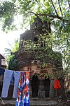
Sridhar Laljiu temple of Mondal family, built in 1807 (front side).

Sridhar Laljiu temple built as a nava ratna temple, now in a ruinous condition (rear side).
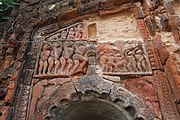
Crumbling terracotta designs at Sridhar Laljiu temple
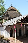
At chala temple adjacent to Sridhar Laljiu temple


References[]
- ^ "District Census Handbook: Hugli, Series-20, Part XIIA" (PDF). Physiography, Page 17-19. Directorate of Census Operations, West Bengal, 2011. Retrieved 25 September 2020.
- ^ "District Statistical Handbook 2014 Hooghly". Table 2.2, 2.4(a). Department of Planning and Statistics, Government of West Bengal. Retrieved 25 September 2020.
- ^ "2011 Census – Primary Census Abstract Data Tables". West Bengal – District-wise. Registrar General and Census Commissioner, India. Retrieved 22 September 2020.
- ^ McCutchion, David J., Late Mediaeval Temples of Bengal, first published 1972, reprinted 2017, pages 46, 52. The Asiatic Society, Kolkata, ISBN 978-93-81574-65-2
- Villages in Hooghly district