Furman, Alabama
Furman, Alabama | |
|---|---|
 Furman, Alabama Location within the state of Alabama | |
| Coordinates: 32°0′24.53″N 86°58′0.94″W / 32.0068139°N 86.9669278°W | |
| Country | United States |
| State | Alabama |
| County | Wilcox |
| Elevation | 292 ft (89 m) |
| Time zone | UTC-6 (Central (CST)) |
| • Summer (DST) | UTC-5 (CDT) |
| Area code(s) | 334 |


Furman, also known as Old Snow Hill, is an unincorporated community in Wilcox County, Alabama, United States.[1] The Furman Historic District is included on the National Register of Historic Places.[2]

Patience Plantation, completed c. 1842

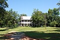
Wakefield Plantation
Perdue-Williams Estes House, completed c. 1895


Demographics[]
| Historical population | |||
|---|---|---|---|
| Census | Pop. | %± | |
| 1890 | 195 | — | |
| 1900 | 184 | −5.6% | |
| 1910 | 125 | −32.1% | |
| 1920 | 190 | 52.0% | |
| 1930 | 229 | 20.5% | |
| U.S. Decennial Census[3] | |||
Furman was listed as an incorporated community from 1890 to 1930 on the U.S. Census rolls. It either disincorporated or lost its charter after 1930.
Geography[]
Furman is located at 32°00′25″N 86°58′01″W / 32.00681°N 86.96692°WCoordinates: 32°00′25″N 86°58′01″W / 32.00681°N 86.96692°W and has an elevation of 292 feet (89 m).[1]
References[]
| Wikimedia Commons has media related to Furman, Alabama. |
- ^ a b U.S. Geological Survey Geographic Names Information System: Furman, Alabama
- ^ "National Register Information System". National Register of Historic Places. National Park Service. April 15, 2008.
- ^ "U.S. Decennial Census". Census.gov. Archived from the original on May 12, 2015. Retrieved June 6, 2013.
Municipalities and communities of Wilcox County, Alabama, United States | ||
|---|---|---|
| City |  | |
| Towns | ||
| CDPs | ||
| Unincorporated communities | ||
| Ghost towns | ||
| ||
This Wilcox County, Alabama state location article is a stub. You can help Wikipedia by . |
Categories:
- Unincorporated communities in Alabama
- Unincorporated communities in Wilcox County, Alabama
- South Alabama geography stubs