Gaidouras
This article needs additional citations for verification. (January 2021) |
Gaidouras | |
|---|---|
village | |
| Γαϊδουράς (Greek) Korkuteli (Turkish) | |
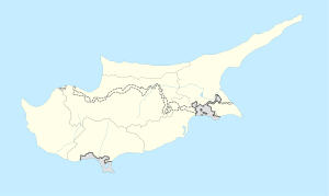 Gaidouras Location in Cyprus | |
| Coordinates: 35°10′1″N 33°47′18″E / 35.16694°N 33.78833°ECoordinates: 35°10′1″N 33°47′18″E / 35.16694°N 33.78833°E | |
| Country (de jure) | |
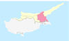
| • District | Famagusta District |
| Country (de facto) | |
| • District | Gazimağusa District |
| Time zone | UTC+2 (EET) |
| • Summer (DST) | UTC+3 (EEST) |

Gaïdouras (Greek: Γαϊδουράς, Turkish: Korkuteli) is a village in the Famagusta District of Cyprus, located 17 km west of Famagusta. It is under the de facto control of Northern Cyprus.
Gaïdouras means "place of donkeys" in Greek. The Gaidouras villagers wanted to change the name of their village to Nea Sparti (New Sparta). They officially applied to the Cypriot Government and it changed. However, in 1974, the Turkish Peace Operation took place. The application has not been processed.
References[]
- ^ In 1983, the Turkish Republic of Northern Cyprus unilaterally declared independence from the Republic of Cyprus. The de facto state is not recognised by any UN state except Turkey.

This Cyprus location article is a stub. You can help Wikipedia by . |
Categories:
- Communities in Famagusta District
- Populated places in Gazimağusa District
- Cyprus geography stubs