Platanissos
Platanissos | |
|---|---|
village | |
| Πλατανισσός (Greek) Balalan (Turkish) | |
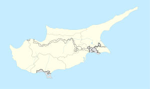 Platanissos Location in Cyprus | |
| Coordinates: 35°28′41″N 34°6′23″E / 35.47806°N 34.10639°ECoordinates: 35°28′41″N 34°6′23″E / 35.47806°N 34.10639°E | |
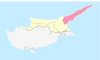
| Country (de jure) | |
| • District | Famagusta District |
| Country (de facto) | |
| • District | İskele District |
| Government | |
| • Mukhtar | Cafer Özbalalanlı |
| Population (2011)[2] | |
| • Total | 89 |
| Time zone | UTC+2 (EET) |
| • Summer (DST) | UTC+3 (EEST) |

Platanissos (Greek: Πλατανισσός, Turkish: Balalan) is a village in the Famagusta District of Cyprus, located on the Karpas Peninsula. It is under the de facto control of Northern Cyprus.
References[]
- ^ In 1983, the Turkish Republic of Northern Cyprus unilaterally declared independence from the Republic of Cyprus. The de facto state is not recognised by any UN state except Turkey.
- ^ KKTC 2011 Nüfus ve Konut Sayımı [Northern Cyprus 2011 Population and Housing Census] (PDF), Northern Cyprus State Planning Organization, 6 August 2013

This Cyprus location article is a stub. You can help Wikipedia by . |
Categories:
- Cyprus geography stubs
- Communities in Famagusta District
- Populated places in İskele District