Gannett Peak
| Gannett Peak | |
|---|---|
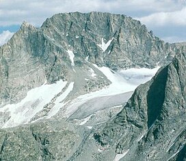 West face of Gannett Peak | |
| Highest point | |
| Elevation | 13,810 ft (4,210 m)[1][2] |
| Prominence | 7,077 ft (2,157 m)[1] |
| Parent peak | Longs Peak[3] |
| Isolation | 290.36 mi (467.29 km)[1] |
| Listing |
|
| Coordinates | 43°11′03″N 109°39′15″W / 43.184202022°N 109.654233614°WCoordinates: 43°11′03″N 109°39′15″W / 43.184202022°N 109.654233614°W[2] |
| Geography | |
 Gannett Peak Wyoming | |
| Location | Fremont and Sublette Counties, Wyoming, United States |
| Parent range | Wind River Range |
| Topo map | USGS Gannett Peak |
| Climbing | |
| First ascent | 1922 by A. Tate and F. Stahlnaker |
| Easiest route | rock/ice climb |

Gannett Peak[4] is the highest mountain peak in the U.S. state of Wyoming at 13,810 feet (4,210 m). It lies in the Wind River Range within the Bridger Wilderness of the Bridger-Teton National Forest. Straddling the Continental Divide along the boundary between Fremont and Sublette counties, it has the second greatest topographic prominence in the state (7076') after Cloud Peak (7077'), and is the highest ground for 290.36 miles (467.29 kilometers) in any direction.
Overview[]
Geographically, Gannett Peak is the apex[clarification needed] of the entire Central Rockies, the largely continuous chain of mountains occupying the states of Wyoming, Idaho and Montana. Named in 1906 for American geographer Henry Gannett,[5] the peak is also the high point of the Wind River Range. The mountain slopes are located in both Bridger-Teton National Forest and Shoshone National Forest.
Gannett is the highest peak within what is better known as the Greater Yellowstone Ecosystem and is the highest peak in the Rocky Mountains outside of Colorado. The 896-acre (3.63 km2) Gannett Glacier, which is likely the largest single glacier in the American portion of the Rocky Mountains, extends across the northern slopes of the mountain. Minor Glacier is situated in the western cirque of the peak while Dinwoody and Gooseneck Glaciers can be found on the southeast side of the mountain.

Gannett Peak is in the heart of a remote and rugged wilderness. Because of this, its elevation, and extreme weather, it is often considered by mountaineers to be one of the most difficult U.S. state high points to reach, after Denali and possibly Granite Peak.[citation needed]
Hazards[]
Encountering bears is a concern in the Wind River Range.[6] There are other concerns as well, including bugs, wildfires, adverse snow conditions and nighttime cold temperatures.[7]
Importantly, there have been notable incidents, including accidental deaths, due to falls from steep cliffs (a misstep could be fatal in this class 4/5 terrain) and due to falling rocks, over the years, including 1993,[8] 2007 (involving an experienced NOLS leader),[9] 2011,[10] 2015,[11] 2017[12] and 2018.[13] Other incidents in the Wind River Range include a seriously injured backpacker being airlifted near SquareTop Mountain[14] in 2005,[15] and a fatal hiker incident (from an apparent accidental fall) in 2006 that involved state search and rescue.[16] The U.S. Forest Service does not offer updated aggregated records on the official number of fatalities in the Wind River Range.
See also[]
- List of mountain peaks of the United States
- List of Ultras of the United States
References[]
- ^ Jump up to: a b c "Gannett Peak, Wyoming". Peakbagger.com. Retrieved May 8, 2018.
- ^ Jump up to: a b "Gannett Peak Cairn". NGS data sheet. U.S. National Geodetic Survey. Retrieved 2008-12-05.
- ^ "Gannett Peak". ListsOfJohn.com. Retrieved 2008-12-05.
- ^ U.S. Geological Survey Geographic Names Information System: Gannett Peak
- ^ Penry, Jerry (27 October 2007). "The Father of Government Mapmaking: Henry Gannett". American Surveyor. Retrieved 2008-09-28.
- ^ Staff (April 24, 2017). "Bear Safety in Wyoming's Wind River Country". WindRiver.org. Retrieved February 17, 2019.
- ^ Ballou, Dawn (July 27, 2005). "Wind River Range condition update - Fires, trails, bears, Continental Divide". PineDaleOnline News. Retrieved February 17, 2019.
- ^ Staff (1993). "Falling Rock, Loose Rock, Failure to Test Holds, Wyoming, Wind River Range, Seneca Lake". American Alpine Club. Retrieved February 15, 2019.
- ^ MacDonald, Dougald (August 14, 2007). "Trundled Rock Kills NOLS Leader". Climbing. Retrieved February 15, 2019.
- ^ "Obituary of Donald Scott | McGuiness Funeral Home". summersfuneral.com. Retrieved 2020-09-09.
- ^ Staff (December 9, 2015). "Officials rule Wind River Range climbing deaths accidental". Casper Star-Tribune. Retrieved February 15, 2019.
- ^ Staff (August 31, 2017). "Climber falls to his death in Wind River Range". County10 News. Retrieved February 15, 2019.
- ^ Dayton, Kelsey (August 24, 2018). "Deadly underestimation". WyoFile News. Retrieved February 15, 2019.
- ^ Funk, Jason (2009). "Squaretop Mountain Rock Climbing". Mountain Project. Retrieved March 29, 2019.
- ^ Staff (July 22, 2005). "Injured man rescued from Square Top Mtn - Tip-Top Search & Rescue helps 2 injured on the mountain". PineDaleOnline News. Retrieved February 17, 2019.
- ^ Staff (September 1, 2006). "Incident Reports - September, 2006 - Wind River Search". WildernessDoc.com. Retrieved February 17, 2019.
External links[]
| Wikimedia Commons has media related to Gannett Peak. |
- "A photo journal of a trip up Gannett Peak". HikingInTheRockies.com.
- "Gannett Peak". The Mountain Man Community. Retrieved 2008-12-05.
- "Gannett Peak". Topographic map. TopoQuest. Retrieved 2008-12-05.
| show Highest natural points of U.S. states and additional U.S. areas |
|---|
| show |
|---|

- Bridger–Teton National Forest
- Highest points of U.S. states
- Mountains of Fremont County, Wyoming
- Mountains of Sublette County, Wyoming
- Mountains of Wyoming
- Shoshone National Forest
- North American 4000 m summits