Gardiner, Montana
Gardiner, Montana | |
|---|---|
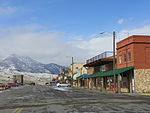
 Downtown, February 1999 | |
 Location of Gardiner, Montana | |
| Coordinates: 45°2′13″N 110°42′50″W / 45.03694°N 110.71389°W | |
| Country | United States |
| State | Montana |
| County | Park |
| Area | |
| • Total | 3.9 sq mi (10.0 km2) |
| • Land | 3.8 sq mi (9.8 km2) |
| • Water | 0.1 sq mi (0.2 km2) |
| Elevation | 5,259 ft (1,603 m) |
| Population (2010) | |
| • Total | 875 |
| • Density | 224.9/sq mi (86.8/km2) |
| Time zone | UTC-7 (Mountain (MST)) |
| • Summer (DST) | UTC-6 (MDT) |
| ZIP code | 59030 |
| Area code(s) | 406 |
| FIPS code | 30-29950 |
| GNIS feature ID | 0783830 |

Gardiner is a census-designated place (CDP) in Park County, Montana, along the 45th parallel. The population was 875 at the time of the 2010 census.
Gardiner was officially founded in 1880, but the area has served as a main entrance to Yellowstone National Park since its creation in 1872. Yellowstone National Park Heritage and Research Center, which opened May 18, 2005, is located in Gardiner and houses National Park Service archives, Yellowstone museum collections and reference libraries.[1][2]
History[]
The name Gardiner derives from Johnson Gardner, a fur trapper who operated in the area in 1830-31.[3] He named the lush headwaters valley of today's Gardner River Gardner's Hole. Originally, named Gardner's Fork, the river took on Gardner's name although prospectors and explorers who visited the area later in the century were unaware of the trapper Johnson Gardner. In 1870, when the Washburn-Langford-Doane Expedition passed through the area they began calling the river Gardiner, a phonetic error. Hiram M. Chittenden (1895) and Nathaniel P. Langford (1905) confirmed this spelling in their accounts of the expedition.[4]
When the Hayden Geological Survey of 1871 passed through the Gardiner area, they encountered two men, named J.C. McCartney and H. R. Horr, who had laid claim to 320 acres (1.3 km2) and established a ranch and bath house on the Mammoth terraces near Liberty Cap. These entrepreneurs eventually established a primitive hotel at Mammoth and were not evicted from the area until many years after the park was established.[5] McCartney also went by the name Jim Gardiner and received messages, consignments and such destined for guests of his hotel addressed to: Jim on the Gardiner. On February 9, 1880, a territorial post office was established just outside the park boundary and Gardiner, Montana began.[4]
In 1883, the Northern Pacific Railway completed the extension of their Park Branch Line from Livingston, Montana to Cinnabar north of Gardiner. In 1903, the line was extended to Gardiner.[6] Railway service at Gardiner station was discontinued in 1948.
Geography[]
Gardiner is located at 45°2′13″N 110°42′50″W / 45.03694°N 110.71389°WCoordinates: 45°2′13″N 110°42′50″W / 45.03694°N 110.71389°W (45.036837, -110.713768).[7]
According to the United States Census Bureau, the CDP has a total area of 3.9 square miles (10 km2), of which 3.8 square miles (9.8 km2) is land and 0.1 square miles (0.26 km2) (2.32%) is water.
Climate[]
Gardiner has a Semi-arid climate with four full seasons. Summers are markedly hot with nights substantially cooling off into the 50's. Winters are not as cold or long as winters experienced by nearby communities such as West Yellowstone or Cooke City that have a location out of the valley.
| hideClimate data for Gardiner | |||||||||||||
|---|---|---|---|---|---|---|---|---|---|---|---|---|---|
| Month | Jan | Feb | Mar | Apr | May | Jun | Jul | Aug | Sep | Oct | Nov | Dec | Year |
| Record high °F (°C) | 58 (14) |
62 (17) |
70 (21) |
85 (29) |
92 (33) |
101 (38) |
103 (39) |
102 (39) |
95 (35) |
87 (31) |
70 (21) |
62 (17) |
103 (39) |
| Average high °F (°C) | 33.1 (0.6) |
38.2 (3.4) |
46.6 (8.1) |
56.1 (13.4) |
66.4 (19.1) |
76.3 (24.6) |
86.2 (30.1) |
84.6 (29.2) |
74.3 (23.5) |
60.6 (15.9) |
42.8 (6.0) |
33.8 (1.0) |
58.2 (14.6) |
| Average low °F (°C) | 14.2 (−9.9) |
17.3 (−8.2) |
23.6 (−4.7) |
30.5 (−0.8) |
38.3 (3.5) |
45.6 (7.6) |
51.9 (11.1) |
50.5 (10.3) |
41.2 (5.1) |
33.4 (0.8) |
23.1 (−4.9) |
16.0 (−8.9) |
32.2 (0.1) |
| Record low °F (°C) | −30 (−34) |
−31 (−35) |
−16 (−27) |
4 (−16) |
11 (−12) |
25 (−4) |
30 (−1) |
30 (−1) |
12 (−11) |
−8 (−22) |
−23 (−31) |
−30 (−34) |
−31 (−35) |
| Average precipitation inches (mm) | 0.43 (11) |
0.34 (8.6) |
0.54 (14) |
0.68 (17) |
1.56 (40) |
1.48 (38) |
1.05 (27) |
0.91 (23) |
0.85 (22) |
0.80 (20) |
0.64 (16) |
0.46 (12) |
9.73 (247) |
| Average snowfall inches (cm) | 5.5 (14) |
3.0 (7.6) |
3.5 (8.9) |
2.8 (7.1) |
0.5 (1.3) |
0.0 (0.0) |
0.0 (0.0) |
0.0 (0.0) |
0.1 (0.25) |
0.4 (1.0) |
4.1 (10) |
5.5 (14) |
25.5 (65) |
| Source: [8] | |||||||||||||
Demographics[]
As of the census[9] of 2000, there were 851 people, 435 households, and 210 families residing in the CDP. The population density was 224.9 people per square mile (86.9/km2). There were 497 housing units at an average density of 131.3 per square mile (50.8/km2). The racial makeup of the CDP was 97.30% White, 0.35% African American, 1.41% Native American, 0.24% Asian, 0.12% from other races, and 0.59% from two or more races. Hispanic or Latino of any race were 0.47% of the population.
There were 435 households, of which 22.1% had children under the age of 18 living with them, 40.0% were married couples living together, 5.7% had a female householder with no husband present, and 51.5% were non-families. 43.2% of all households were made up of individuals, and 4.8% had someone living alone who was 65 years of age or older. The average household size was 1.96 people and the average family size 2.73.
In the CDP, the age of the population was spread out, with 20.8% under the age of 18, 2.9% from 18 to 24, 40.5% from 25 to 44, 28.0% from 45 to 64, and 7.8% who were 65 years of age or older. The median age was 39 years. For every 100 females, there were 96.5 males. For every 100 females age 18 and over, there were 99.4 males.
The median income for a household in the CDP was $30,125, and the median income for a family was $46,071. Males had a median income of $30,240 versus $17,614 for females. The per capita income for the CDP was $17,810. About 3.4% of families and 8.2% of the population were below the poverty line, including 4.8% of those under age 18 and none of those age 65 or over.
Images of Gardiner[]

McCartney's Hotel - Precursor of the Gardiner settlement

Gardiner, Park County, Montana, Looking North East, 1887. A one-sided street backed up to rocky foothills

Northern Pacific Railway Terminal Postcard, F. Jay Haynes

Parks' Fly Shop, 2nd Street, 2009
Park Street, October 2009 with Roosevelt Arch

Red's Blue Goose
Tinker's Cemetery, just north of town in Yellowstone National Park


Infrastructure[]
Gardiner Airport is a public use airport located two miles (3.7 km) northwest of town.
Education[]
Gardiner Public Schools has a single educational building. Its divisions:[10]
- Gardiner School (Grades K-6; 101 students)
- Gardiner 7-8 School (Grades 7-8; 44 students)
- Gardiner High School (Grades 9-12; 85 students)
Media[]
| AM radio | FM radio | Television |
|---|---|---|
| KBOZ 1090 | KOBB-FM 93.7 | KTVM 6 NBC |
| KOBB 1230 | KMMS-FM 94.7 | KBZK 7 CBS |
| 1340 | KISN 96.7 | KUSM 9 PBS |
| KMMS 1450 | KOZB 97.5 | |
| KBOZ-FM 99.9 Gardiner Field, Montana was reported destroyed by an "enemy A-bomb" in the movie Invasion U.S.A. | ||
| KXLB 100.7 | ||
| KZMY 103.5 | ||
| KBZM 104.7 | ||
| KSCY 106.9 |
See also[]
- Angling in Yellowstone National Park
- The Summit Lighthouse - international headquarters located in Gardiner
- North Entrance Road Historic District
References[]
- ^ "Yellowstone National Park Heritage and Research Center". Retrieved 2009-12-19.
- ^ "Heritage and Research Center". National Park Service. Retrieved 2009-12-09.
- ^ "Gardiner". Montana Place Names Companion. Montana Historical Society. Retrieved 2 April 2021.
- ^ Jump up to: a b Haines, Aubrey L. (1996). Yellowstone Place Names-Mirrors of History. Niwot, Colorado: University Press of Colorado. pp. 24–27. ISBN 0-87081-382-X.
- ^ Culpin, Mary Shivers (2003). For the Benefit and Enjoyment of the People: A History of Concession Development in Yellowstone National Park-1872-1966. Yellowstone National Park, WY: Yellowstone Center for Resources.
- ^ Haines, Aubrey L. (1996). Yellowstone Place Names-Mirrors of History. Niwot, Colorado: University Press of Colorado. p. 253. ISBN 0-87081-382-X.
- ^ "US Gazetteer files: 2010, 2000, and 1990". United States Census Bureau. 2011-02-12. Retrieved 2011-04-23.
- ^ "GARDINER, MONTANA - Climate Summary". Western Regional Climate Center. Retrieved August 20, 2016.
- ^ "U.S. Census website". United States Census Bureau. Retrieved 2008-01-31.
- ^ "About". Gardiner Public Schools. Retrieved 2020-01-19.
External links[]
 Media related to Gardiner, Montana at Wikimedia Commons
 Gardiner, Montana travel guide from Wikivoyage
| show Municipalities and communities of Park County, Montana, United States |
|---|

| show Yellowstone National Park - Mammoth Hot Springs |
|---|

| show Authority control |
|---|
- Census-designated places in Park County, Montana
- Census-designated places in Montana
- 1880 establishments in Montana Territory