Gave d'Oloron
| Gave d'Oloron | |
|---|---|
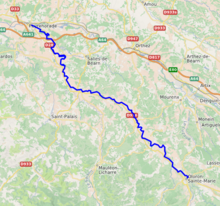
 The Gave d'Oloron in Sauveterre-de-Béarn | |
 | |
| Location | |
| Country | France |
| Physical characteristics | |
| Source | |
| • location | Pyrenees |
| Mouth | |
• location | Gave de Pau |
• coordinates | 43°32′24″N 1°5′24″W / 43.54000°N 1.09000°WCoordinates: 43°32′24″N 1°5′24″W / 43.54000°N 1.09000°W |
| Length | 148.8 km (92.5 mi) |
| Basin size | 2,456 km2 (948 sq mi) |
| Discharge | |
| • average | 102 m3/s (3,600 cu ft/s) |
| Basin features | |
| Progression | Gaves réunis→ Adour→ Atlantic Ocean |

The Gave d'Oloron
The Gave d'Oloron is a river of south-western France near the border with Spain. It takes its name from the city Oloron-Sainte-Marie, where it is formed from the rivers Gave d'Aspe and Gave d'Ossau. It joins the Gave de Pau in Peyrehorade to form the Gaves réunis, a tributary of the Adour. The Gave d'Oloron is used for fishing. The river is 148 kilometres (92 mi) long, including its source rivers Gave d'Ossau and Gave du Brousset.[1]
The Gave d'Oloron flows through the following départements and towns:
References[]
| Authority control |
|
|---|
This Nouvelle-Aquitaine geographical article is a stub. You can help Wikipedia by . |
Categories:
- Tributaries of the Gaves réunis
- Rivers of France
- Rivers of Pyrénées-Atlantiques
- Rivers of Landes (department)
- Gave d'Oloron basin
- Rivers of Nouvelle-Aquitaine
- Nouvelle-Aquitaine geography stubs
- France river stubs