Gavirate
Gavirate | |
|---|---|
| Comune di Gavirate | |
show Location of Gavirate | |
 Gavirate Location of Gavirate in Italy | |
| Coordinates: 45°51′N 8°43′E / 45.850°N 8.717°ECoordinates: 45°51′N 8°43′E / 45.850°N 8.717°E | |
| Country | Italy |
| Region | Lombardy |
| Province | Province of Varese (VA) |
| Frazioni | Oltrona al Lago, Voltorre |
| Area | |
| • Total | 13.3 km2 (5.1 sq mi) |
| Elevation | 261 m (856 ft) |
| Population (Dec. 2004)[2] | |
| • Total | 9,438 |
| • Density | 710/km2 (1,800/sq mi) |
| Demonym(s) | Gaviratesi |
| Time zone | UTC+1 (CET) |
| • Summer (DST) | UTC+2 (CEST) |
| Postal code | 21026 |
| Dialing code | 0332 |
| Website | Official website |


Gavirate is a comune (municipality) in the Province of Varese in the Italian region of Lombardy, located about 60 kilometres (37 mi) northwest of Milan and about 10 kilometres (6 mi) northwest of Varese. As of 31 December 2004, it had a population of 9,438 and an area of 13.3 square kilometres (5.1 sq mi).[3]
The municipality of Gavirate contains the frazioni (hamlets) Oltrona al Lago, Voltorre and other mainly villages: Groppello, Le Vigne, Fignano, Forte di Orino, Fienile delle Pianezze, Armino, Pozzuolo, Cual, Ca'de Monti, Ronco, and Benedetto.
Gavirate borders the following municipalities: Barasso, Bardello, Besozzo, Biandronno, Casciago, Cocquio-Trevisago, Comerio, Cuvio, Varese.
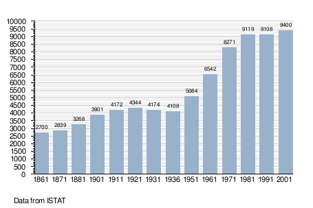
Demographic evolution[]
References[]
- ^ "Superficie di Comuni Province e Regioni italiane al 9 ottobre 2011". Istat. Retrieved 16 March 2019.
- ^ "Popolazione Residente al 1° Gennaio 2018". Istat. Retrieved 16 March 2019.
- ^ All demographics and other statistics: Italian statistical institute Istat.
External links[]
This article on a location in the Province of Varese is a stub. You can help Wikipedia by . |
- Cities and towns in Lombardy
- Municipalities of the Province of Varese
- Province of Varese geography stubs