Geiyo Islands
Native name: 芸予諸島 Geiyo Islands | |
|---|---|
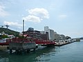
 View of Geiyo Islands and Shimanami Kaidō from Imabari, Ehime | |
 Geiyo Islands Location in Japan | |
| Geography | |
| Location | Seto Inland Sea |
| Coordinates | 34°17′02″N 133°05′03″E / 34.283967°N 133.084169°ECoordinates: 34°17′02″N 133°05′03″E / 34.283967°N 133.084169°E |
| Archipelago | yes |
| Major islands | 43 |
| Length | 98 km (60.9 mi) |
| Width | 38 km (23.6 mi) |
| Administration | |
Japan | |
| Prefecture | Hiroshima and Ehime |
| Demographics | |
| Ethnic groups | Japanese |


The Geiyo Islands (芸予諸島, Geiyo Shotō) are a group of islands in the Seto Inland Sea, under the administration of Hiroshima Prefecture and Ehime Prefecture. Some of the largest islands in archipelago are connected by the Nishiseto Expressway bridge system connecting Honshu and Shikoku.
The Geiyo Archipelago is roughly defined as lying in the western part of Seto Inland Sea, from to . A narrower definition of the archipelago only includes the islands between the former provinces of Iyo and Bizen. The islands of in Hiroshima Bay, most notably Etajima and Kurahashi-jima, are therefore excluded from the latter definition.
Economy and industry[]
Due to the calm yet deep waters of the Seto Inland Sea, the Geiyo Islands are one of the main hubs of shipbuilding,[1] fishing, and aquaculture in Japan.
List of islands[]
The largest islands in the group, each with an area of more than 20 km2, are:
Other notable islands in the group include:
The following islands may sometimes be included under the archipelago's broader definition:
Gallery[]
The urban area of Innoshima

in Etajima (the former Imperial Japanese Naval Academy)

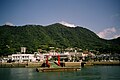
The fishing port in


References[]
- Geiyo Islands
- Archipelagoes of Japan
- Islands of Hiroshima Prefecture
- Islands of Ehime Prefecture
- Islands of the Seto Inland Sea
- Archipelagoes of the Pacific Ocean