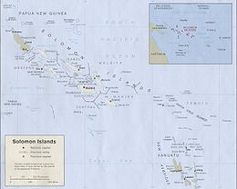
Geography of the Solomon Islands
 | |
| Continent | Pacific Ocean |
|---|---|
| Region | Oceania |
| Coordinates | 8°00′S 159°00′E / 8.000°S 159.000°E |
| Area | Ranked 139th |
| • Total | 28,896 km2 (11,157 sq mi) |
| • Land | 96.8% |
| • Water | 3.2% |
| Coastline | 5,313 km (3,301 mi) |
| Borders | None |
| Highest point | Mount Popomanaseu 2,332 metres (7,651 ft) |
| Lowest point | Pacific Ocean 0 m |
| Exclusive economic zone | 1,589,477 km2 (613,701 sq mi) |

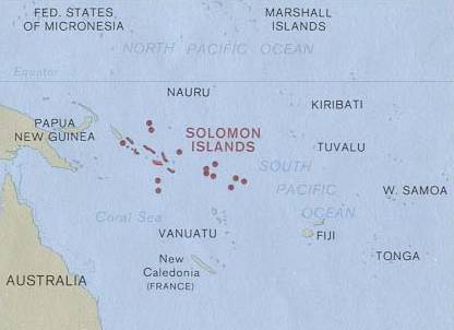
Solomon Islands is a nation in the South Pacific Ocean, that lies east of Papua New Guinea.
Islands[]
The major part of the nation of the Solomon Islands is the mountainous High islands of the Solomon Islands archipelago, which includes Choiseul, the Shortland Islands, the New Georgia Islands, Santa Isabel, the Russell Islands, the Florida Islands, Tulagi, Malaita, Maramasike, Ulawa, Owaraha (Santa Ana), Makira (San Cristobal), and the main island of Guadalcanal. Bougainville Island is the largest in the archipelago, while it is geographically part of the Solomon Islands archipelago, it is politically an autonomous region of Papua New Guinea. The Solomon Islands also includes isolated low-lying coral atolls and high islands including Sikaiana, Rennell Island, Bellona Island, the Santa Cruz Islands and the remote, tiny outliers, Tikopia, Anuta, and Fatutaka.
The distance between the most western and most eastern islands is about 1,500 km (930 mi). Especially the Santa Cruz Islands, north of Vanuatu, are isolated at more than 200 km (120 mi) from the other islands. The total land size is 28,896 km2 (11,157 sq mi). It has the 22nd largest Exclusive Economic Zone of 1,589,477 km2 (613,701 sq mi).
Bougainville is geographically part of the Solomon Islands archipelago, but politically an autonomous region of Papua New Guinea.
Geology and ecology[]
Volcanoes with varying degrees of activity are situated on some of the larger islands, while many of the smaller islands are simply tiny atolls covered in sand and palm trees.
The baseline survey of marine biodiversity in the Solomon Islands that was carried out in 2004,[1] found 474 species of corals in the Solomons as well as nine species which could be new to science. This is the second highest diversity of corals in the World, second only to the Raja Ampat Islands in eastern Indonesia.[2]
Climate[]
The climate is tropical, though temperatures are rarely extreme due to cooling winds blowing off the surrounding seas. Daytime temperatures are normally 25 to 32 °C (77 to 90 °F). From April to October (the dry season), the southeast trade winds blow, gusting at times up to 30 knots (55 km/h) or more.
November to March is the wet season—the northwest monsoon—typically warmer and wetter. Cyclones arise in the Coral Sea and the area of the Solomon Islands, but they usually veer toward Vanuatu and New Caledonia or down the coast of Australia.
Statistics[]
Geographic coordinates: 8°00′S 159°00′E / 8.000°S 159.000°E
Area:
total:
28,896 km² (10,985 mi²)
land:
27,986 km² (10,633 mi²)
water:
910 km² (351 mi²)
Coastline: 5,313 km
Maritime claims:
Measured from claimed archipelagic baselines
continental shelf:
200 nmi (230 mi; 370 km)
exclusive economic zone:
1,589,477 km2 (613,701 sq mi) (200 nmi)
territorial sea: 12 nmi (14 mi; 22 km)
Terrain: Mostly rugged mountains with some low coral atolls
Elevation extremes:
lowest point:
Pacific Ocean 0 m
highest point:
Mount Popomanaseu 2,332 m (7,651 ft) (not Mount Makarakomburu)
Natural resources: fish, forests, gold, bauxite, phosphates, lead, zinc, nickel
Land use:
arable land:
0.62%
permanent crops:
2.04%
other:
97.34% (2005)
Irrigated land: NA
Natural hazards: Typhoons, but they are rarely destructive; geologically active region with frequent earth tremors; volcanic activity
Environment - current issues: Deforestation; soil erosion; much of the surrounding coral reefs are dead or dying
Environment - international agreements:
party to: Biodiversity, Climate Change, Climate Change-Kyoto Protocol, Desertification, Environmental Modification, Law of the Sea, Marine Dumping, Marine Life Conservation, Ozone Layer Protection, Whaling
Extreme points[]
This is a list of the extreme points of Solomon Islands, the points that are farther north, south, east or west than any other location.
- Northernmost point – Ontong Java Atoll, Malaita Province
- Easternmost point – Fatutaka, Santa Cruz Islands, Temotu Province
- Southernmost point – South Reef, Indispensable Reef, Rennell and Bellona Province
- Westernmost point - Mono Island, Treasury Islands, Western Province
See also[]
- Provinces of Solomon Islands
- List of mammals of the Solomon Islands
References[]
- ^ Turak, E. with Green, A., P. Lokani, W. Atu, P. Ramohia, P. Thomas and J. Almany (eds.). (2006). Solomon Islands Marine Assessment: Technical report of survey conducted May 13 to June 17, 2004. TNC Pacific Island Countries Report No. 1/06 (PDF) (Report). DC: World Resources Institute. pp. 65–109. Retrieved 31 March 2021.CS1 maint: multiple names: authors list (link)
- ^ Doubilet, David (2007). Ultra Marine: In far eastern Indonesia, the Raja Ampat islands embrace a phenomenal coral wilderness. National Geographic, September 2007. Originally retrieved from http://ngm.nationalgeographic.com/2007/09/indonesia/doubilet-text. Archived on 2008-04-09 at https://web.archive.org/web/20080409084522/http://ngm.nationalgeographic.com/2007/09/indonesia/doubilet-text.
| show Solomon Islands articles |
|---|

![]() This article incorporates public domain material from the CIA World Factbook website https://www.cia.gov/the-world-factbook/.
This article incorporates public domain material from the CIA World Factbook website https://www.cia.gov/the-world-factbook/.
- Geography of the Solomon Islands