Gifford, Florida
This article needs additional citations for verification. (March 2018) |
Gifford, Florida | |
|---|---|
 Location in Indian River County and the state of Florida | |
| Coordinates: 27°40′19″N 80°24′59″W / 27.67194°N 80.41639°WCoordinates: 27°40′19″N 80°24′59″W / 27.67194°N 80.41639°W | |
| Country | |
| State | |
| County | Indian River |
| Area | |
| • Total | 2.72 sq mi (7.04 km2) |
| • Land | 2.72 sq mi (7.04 km2) |
| • Water | 0.00 sq mi (0.00 km2) |
| Elevation | 13 ft (4 m) |
| Population (2020) | |
| • Total | 5,511 |
| • Density | 2,000/sq mi (780/km2) |
| Time zone | UTC-5 (Eastern (EST)) |
| • Summer (DST) | UTC-4 (EDT) |
| ZIP codes | 32967 |
| Area code(s) | 772 |
| FIPS code | 12-25925[2] |
| GNIS feature ID | 0283063[3] |
| Website | www |

Gifford (/ˈɡɪfərd/) is an unincorporated community and census-designated place (CDP) in Indian River County, Florida, United States. It is part of the Sebastian–Vero Beach Metropolitan Statistical Area. The population was 9,590 at the 2010 census,[4] up from 7,599 at the 2000 census. Gifford has a rich African American history.
History[]
The settlement of Gifford was organized in the mid-1880s, according to the Indian River County Historical Society. The area was named as the Woodley precinct in the 1900 census, and as a settlement village for black families, the community grew. By 1893, the early settlers of Gifford had been joined by black laborers who had come to work on Henry Flagler's new railroad project, the Florida East Coast Railway. The residents named the small agricultural community Brownsville after farmer William Brown who settled there in 1880s, but another town in North Florida carried the same name. Instead, the community was named after Charlie Gifford, the railroad's stationmaster and Henry T. Gifford's son.[5]
The town's first school was built in 1898, but only served white children. In 1901 William Edward Geoffrey, a black man from Darlington, South Carolina who had come to work on the railroad, set up school for black children.[5]
In 2018, the Historic Macedonia Church was converted into the Gifford Historical Museum by the Gifford Community Cultural & Resource Center (GCCRC).[5][6]
One of the highlights of Gifford is the Victor Hart Sr. Community Enhancement Complex located at the northern end of 43rd Avenue. The complex was renamed in 2017 to honor Mr. Hart for his work and outreach in the community.[7][8]
Geography[]
Gifford is in eastern Indian River County, on the west side of the Indian River, a tidal channel. It is bordered to the south by Vero Beach, the county seat; to the north by Winter Beach; and to the east, across the Indian River, by Indian River Shores. U.S. Route 1 passes through the center of Gifford, leading north 10 miles (16 km) to Sebastian and south through Vero Beach 17 miles (27 km) to Fort Pierce. Interstate 95 at Exit 147 is 9 miles (14 km) west of Gifford.
According to the United States Census Bureau, the Gifford CDP has a total area of 7.31 square miles (18.94 km2), of which 6.81 square miles (17.65 km2) are land and 0.50 square miles (1.29 km2), or 6.79%, are water.[4]
Demographics[]
| Historical population | |||
|---|---|---|---|
| Census | Pop. | %± | |
| 2020 | 5,511 | — | |
As of the census[2] of 2000, there were 7,599 people, 3,036 households, and 1,897 families residing in the CDP. The population density was 1,078.1 people per square mile (416.2/km2). There were 3,595 housing units at an average density of 510.0/sq mi (196.9/km2). The racial makeup of the CDP was 38.70% White, 57.43% African American, 0.16% Native American, 0.25% Asian, 1.96% from other races, and 1.50% from two or more races. Hispanic or Latino of any race were 6.67% of the population.
There were 3,036 households, out of which 26.4% had children under the age of 18 living with them, 37.8% were married couples living together, 20.5% had a female householder with no husband present, and 37.5% were non-families. 31.9% of all households were made up of individuals, and 17.9% had someone living alone who was 65 years of age or older. The average household size was 2.42 and the average family size was 3.03.
In the CDP, the population was spread out, with 26.2% under the age of 18, 7.9% from 18 to 24, 22.8% from 25 to 44, 20.2% from 45 to 64, and 22.9% who were 65 years of age or older. The median age was 40 years. For every 100 females, there were 84.2 males. For every 100 females age 18 and over, there were 80.3 males.
The median income for a household in the CDP was $29,438, and the median income for a family was $35,354. Males had a median income of $25,716 versus $18,821 for females. The per capita income for the CDP was $19,910. About 19.6% of families and 23.4% of the population were below the poverty line, including 32.3% of those under age 18 and 16.4% of those age 65 or over.
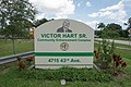
Victor Hart Sr. Community Enhancement Comple

Gifford Historical Museum
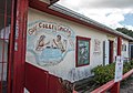
Guy Colley Grocery & Deli


Notable residents[]
- YNW Melly, Rapper
References[]
- ^ "2020 U.S. Gazetteer Files". United States Census Bureau. Retrieved October 31, 2021.
- ^ a b "U.S. Census website". United States Census Bureau. Retrieved 2008-01-31.
- ^ "US Board on Geographic Names". United States Geological Survey. 2007-10-25. Retrieved 2008-01-31.
- ^ a b "Geographic Identifiers: 2010 Census Summary File 1 (G001): Gifford CDP, Florida". American Factfinder. U.S. Census Bureau. Archived from the original on February 13, 2020. Retrieved March 26, 2018.
- ^ a b c Begley, Janet (August 8, 2019). "Centennial: Gifford community started as settlement in the mid-1880s". TCPalm. TCPalm. Retrieved September 18, 2021.
- ^ https://www.giffordhistoricalmuseum.org/
- ^ http://giffordflorida.com/
- ^ "Gifford Park renamed to honor Victor Hart Sr. - All News, Featured News Secondary, News - gifford park, Indian River County, park dedication, victor hart". 21 October 2017.
- ^ "Census of Population and Housing". Census.gov. Retrieved June 4, 2016.
External links[]
| Wikimedia Commons has media related to Gifford, Florida. |
Municipalities and communities of Indian River County, Florida, United States | ||
|---|---|---|
| Cities |  | |
| Towns | ||
| CDPs | ||
| Unincorporated communities | ||
| ||
- Unincorporated communities in Indian River County, Florida
- Unincorporated communities in Florida
- Census-designated places in Indian River County, Florida
- Census-designated places in Florida
- Populated places on the Intracoastal Waterway in Florida