Girvin, Saskatchewan
Girvin | |
|---|---|
 King Street | |
| Motto(s): Here People Count | |
 Location of Girvin in Saskatchewan | |
| Coordinates: 51°09′00″N 105°55′02″W / 51.15°N 105.9172°W | |
| Country | Canada |
| Province | Saskatchewan |
| Region | Saskatchewan |
| Census division | 11 |
| Rural Municipality | Arm River |
| unincorporated (Hamlet) | December 19, 2005 |
| Area | |
| • Total | 3.8 km2 (1.5 sq mi) |
| Population (2006) | |
| • Total | 20 |
| • Density | 5.3/km2 (14/sq mi) |
| Postal code | S0G 1X0 |
| Area code(s) | 306 |
| Highways | Highway 11 Highway 749 |
| Waterways | |
| [1][2][3][4] | |


Girvin is a former village of 20 people in Saskatchewan, Canada. It is located midway between Regina and Saskatoon on Highway 11 between the towns of Davidson and Craik. The village was formally dissolved in 2005; its remaining population is now counted as part of the rural municipality of Arm River.[5]
Demographics[]
Prior to December 19, 2005, Girvin was unincorporated as a village, and was restructured as a hamlet under the jurisdiction of the Rural municipality of Big Arm on that date.[6]
| hideCanada census – Girvin, Saskatchewan community profile | |||
|---|---|---|---|
| 2006 | |||
| Population: | 20 (-20.0% from 2001) | ||
| Land area: | 3.8 km2 (1.5 sq mi) | ||
| Population density: | 5.3/km2 (14/sq mi) | ||
| Median age: | NA (M: NA, F: NA) | ||
| Total private dwellings: | 21 | ||
| Median household income: | $NA | ||
| References: 2006[7] earlier[8] | |||
History[]
The town’s name was in honour of John Alexander Girvin, a Winnipeg-based contractor who was responsible for the construction of countless railroad stations across the prairies.[9] The Qu’Appelle, Long Lake, and Saskatchewan Railroad and Steamboat Company railway passed through the area in the 1880s. Settlement of the area followed soon after, in about 1902 and consisted mostly of immigrants from Ontario. A school (which closed in 1970) and post office opened April 1, 1905 with a restaurant, veterinarian, Massey-Harris dealership, lumber yard, butcher, hotel, bank, livery, blacksmith and a 3 story hotel following soon after. In 1907, the community had grown to such a size that it was incorporated as a village. Over the next few years, the town continued to grow and at its height,[10] in 1915, the town boasted three grain elevators (the British America elevator, the Canadian Elevator Company elevator and the S.G. Detchon elevator.) The town also boasted hockey, football, curling and baseball teams. Girvin’s population peaked at 151 people in 1926 but slid to only 93 residents in 1941, only to rebound slightly in the 1950s with 140 people. This however, was only a short-term reprieve. Beginning in the 1960s, the population once again began to fall. By the 1980s the only business left in town was a gas station and garage. In 2004 the skating rink collapsed. Girvin lost its village status on December 19, 2005.[11]
Today there are twenty residents with no businesses but the town is home to a large metal sculpture of a bison and Red River Cart created by Don Wilkins.[12]
Attractions[]
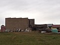
The Girvin Pump House, constructed in 1906, is situated on a 380-square metre piece of land near the railway tracks. It provided water for horses hauling grain into town and some townspeople also used its water for doing laundry. It is the only pump house in Saskatchewan and has been recognized as a Municipal Heritage Property since 1994.[13] Originally, it worked by the way of a gas pump that drew water to a tank at the top of the pump house. The tower portion of this building is a smaller version of the traditional railway water towers that were common across the prairies. The gas pump was subsequently replaced with an electric one. When the horses needed water, a rope was pulled, which released the water and filled a horse trough at the front of the building. Eventually, as cars and tractors replaced horses on the farm, the pump house fell out of use.[14]
Gallery[]
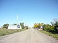
View down King Street


Sign for Girvin on Highway 11


See also[]
- List of communities in Saskatchewan
- Hamlets of Saskatchewan
References[]
- ^ National Archives, Archivia Net, Post Offices and Postmasters, archived from the original on 2006-10-06
- ^ Government of Saskatchewan, MRD Home, Municipal Directory System, archived from the original (– Scholar search) on November 21, 2008
- ^ Canadian Textiles Institute. (2005), CTI Determine your provincial constituency, archived from the original on 2007-09-11
- ^ Commissioner of Canada Elections, Chief Electoral Officer of Canada (2005), Elections Canada On-line, archived from the original on 2007-04-21
- ^ "Saskatchewan Health Covered Population 2006". Saskatchewan Health. 2006-06-30. Archived from the original on 2009-04-13. Retrieved 2008-10-21.
- ^ "Restructured Villages". Saskatchewan Ministry of Municipal Affairs. Archived from the original on March 25, 2008. Retrieved 2008-02-10.
- ^ "2006 Community Profiles". 2006 Canadian Census. Statistics Canada. March 30, 2011. Retrieved 2009-02-24.
- ^ "2001 Community Profiles". 2001 Canadian Census. Statistics Canada. February 17, 2012.
- ^ "Memorable Manitobans: John Alexander Girvin (1851-1931)". www.mhs.mb.ca. Retrieved 2019-04-07.
- ^ Clancy, Michael and Anna (2011). Lake Diefenbaker: Yours to Discover. Canada: Canadian Plains Research Centre. p. 128.
- ^ McLennan, David (2008). Our Towns: Saskatchewan Communities from Abbey to Zenon Park. Canada: Canadian Plains Research Centre. p. 139.
- ^ "About Don Wilkins". www.donwilkins.net. Retrieved 2019-04-08.
- ^ Girvin Pump House http://heritageapp.cyr.gov.sk.ca/assets/pdf/48.pdf Archived 2011-07-06 at the Wayback Machine
- ^ "HistoricPlaces.ca - HistoricPlaces.ca". www.historicplaces.ca. Retrieved 2019-04-07.
| show Places adjacent to Girvin, Saskatchewan |
|---|
| show |
|---|
- Arm River No. 252, Saskatchewan
- Designated places in Saskatchewan
- Former villages in Saskatchewan
- Unincorporated communities in Saskatchewan
- Populated places disestablished in 2005
- Heritage sites in Saskatchewan