List of ghost towns in Saskatchewan
This list is incomplete; you can help by . (August 2008) |
The following is a list of communities that no longer exist or former Villages/Towns that have become unincorporated hamlets in the province of Saskatchewan, Canada.
Ghost towns are towns that once had a considerable population, that have since dwindled in numbers causing some or all its business to close, either due to the rerouting of a highway, train tracks being pulled, or exhaustion of a natural resource. One of the more famous stories of Saskatchewan ghost towns arose around Uranium City which was close to achieving city status and utterly collapsed upon the closure of the Eldorado mine and the mass exodus of its population.[1]
Initially travel began by horse and wagon or ox and cart along trails which generally followed animal trails across the North-West Territories. Railways would not build across the western frontier without settlement as it would be too costly to provide train service across a barren wilderness.[2] The Clifford Sifton immigration policy encouraged settlers to arrive.[3] Western settlement began and immigration encroached across the Manitoba border into the North-West Territories later to become the Province of Saskatchewan in 1905. Rail stations, post offices, schools, and towns sprang up approximately 6 miles (9.7 km) to 10 miles (16 km) apart to accommodate ox and cart as well as horse and wagon travel.[4][5] As travel evolved to automobiles, there was no longer a need for centres this close together. In the 1940s when the highway became more popular, and the rail branch lines started to close down, saw the demise of sidings and villages located on the rail line but not on the highway. In the late 1950s and 1960s when highways were straightened and developed from gravel to asphalt and oil surface highways many of the bypassed towns and villages folded. Businesses set up shop in towns on the new straightened highway,[6] and children could be bused to composite schools in the larger centres. The following placenames may exist only as commemorative road names which intersect the current highways and have disappeared altogether or they may be unincorporated areas of the Rural Municipality|RM such as Floral, the birthplace of Gordie Howe. Floral would be currently located off the Yellowhead highway for example but it was on Provincial Highway 5 when the road was on the square. Floral currently is demarked by an old church at the Floral Cemetery, and the Floral one room school is now the community hall for meetings and social gatherings. The only remembrance of Floral is a road named Floral road. The road travelled on the 'square' connecting many small country towns was a different one from the highway of today connecting larger urban centres.
A rural municipality, often abbreviated RM, is a form of municipality consisting of an elected reeve for the elected head along with aldermen or Councillors of a rural municipality, performing a similar role to the mayor of a village, town or city.[7] An RM may have its office in a town or village, which has its own separate and distinct civic administration, but the RM administers the rural affairs of a large land area including unincorporated areas or ghost towns. The RM administers the remaining population of the ghost town providing any needed civic infrastructure, safety, health, educational, or tourism affairs. Localities with small populations are enumerated in census taking by Statistics Canada as a population belonging to the RM. For instance Churchbridge No. 211 includes the localities of Beresina and the Melville Airport.[8]

List of ghost towns[]
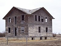
East Poplar Saskatchewan. Hart Butte No.11| Name | Rural municipality (RM) |
Land Address | Lat/Long |
|---|---|---|---|
| Amulet | Norton No. 16 | 49°36'58.3" N 104°45'19.4 "W | |
| Arena | Frontier No. 19 | 49°07'2.3" N 109°16'00.1" W | |
| Auburnton | Moose Creek No. 33 | 49°24'23" N 102°4'25" W | |
| Baildon | Baildon No. 131 | ||
| Bateman | Gravelbourg No. 104 | 49°41′28.9″ N 107°51′14.6″ W | |
| Battrum | Riverside No. 168 | 50°32'55.0" N 108°20'05.3" W | |
| Bayard | Terrell No. 101 | 50°01'18.8" N 105°17'27.2" W | |
| Bents | Marriott No. 317 | 51°49'24.2" N 107°43'43.0" W | |
| Emerald No. 277 | Sec.10, Twp.30, R.14, W2 | ||
| Cymri No. 36 | SW Sec.12, Twp.5, R.10, W2 | 49°21'58.41" N 103°14'02.23" W | |
| Bonne Madone | Hoodoo No. 401 | 52°40'20.2" N 105°31'22.7" W | |
| Bounty | Fertile Valley No. 285 | 51°31'20.9" N 107°21'41.7" W | |
| Browning No. 34 | |||
| Bresaylor | Paynton No. 470 | 52°58'06.6" N 108°45'49.3" W | |
| Bromhead | Souris Valley No. 7 | Sec.3, Twp.3, R.13, W2 | 49°10'46.9" N -103°40'34.7" W |
| Brooking | Laurier No. 38 | 49°30'34.7" N 104°25'21.3" W | |
| Browning | Browning No. 34 | 49°26'07.8" N 102°38'02.4" W | |
| Bryant | Benson No. 35 | SW Sec.12 Twp.5 R.9, W2 | 49°22'37.7" N 103°06'16.4" W |
| Buffalo Gap | 49°06'31.7" N 105°16'41.5" W | ||
| Cactus Lake | Heart's Hill No. 352 | ||
| Biggar No. 347 | |||
| Canuck | Lone Tree No. 18 | ||
| Chandler | Cymri No. 36 | SW Sec.10, Twp.5, R.11, W2 | 49°21'48.7" N 103°25'08.4" W |
| Claydon | Frontier No. 19 | ||
| Brokenshell No. 68 | |||
| Coalfields No. 4 | |||
| Colgate | Lomond No. 37 | SE Sec.24 Twp.5 R.15, W2 | 49°23'40.0" N 103°53'42.0" W |
| Court | Antelope Park No. 322 | ||
| Crichton | Wise Creek No. 77 | ||
| Cullen | Benson No. 35 | NW-SW Sec.7 Twp.5 R.7, W2 | 49°22'09.3" N 102°56'52.2" W |
| Cummings | Maple Creek No. 111 | ||
| Diana | Bratt's Lake No. 129 | ||
| Divide | Reno No. 51 | ||
| Buchanan No. 304 | |||
| Sliding Hills No. 273 | |||
| Invermay No. 305 | |||
| Dummer | Caledonia No. 99 | ||
| Enniskillen No. 3 | |||
| Elswick | Cymri No. 36 | NW Sec.2 Twp.5 R.12, W2 | 49°22'00.0" N 103°32'02.0" W |
| Estuary | Deer Forks No. 232 | ||
| Expanse | Lake Johnston No. 102 | ||
| Stonehenge No. 73 | |||
| Floral | Corman Park No. 344 | Sec.4 Twp.36 R.4, W3 | 52°03′25″ N 106°30′40″ W |
| Forward | Norton No. 69 | ||
| Froude | Griffin No. 66 | ||
| Fusilier | Antelope Park No. 322 | ||
| Weyburn No. 67 | |||
| Galilee | Terrell No. 101 | ||
| Gallivan | Cut Knife No. 439 | ||
| Gibbs | Longlaketon No. 219 | ||
| Girvin | Arm River No. 252 | ||
| St. Andrews No. 287 | |||
| Glasnevin | 49°33'00.9" N 105°03'17.7" W | ||
| Glen Bain No. 105 | |||
| Glen Kerr | Morse No. 165 | ||
| Goodwater | Lomond No. 37 | 49°23'46.6" N 103°42'36.8" W | |
| Gouldtown | Morse No. 165 | ||
| Auvergne No. 76 | |||
| Govenlock | Reno No. 51 | ||
| Weyburn No. 67 | |||
| Estevan No. 5 | |||
| Hallonquist | Coulee No. 136 | ||
| Handsworth | Golden West No. 95 | ||
| Hardy | The Gap No. 39 | ||
| Harptree | Bengough No. 40 | ||
| Hatton | Maple Creek No. 111 | ||
| Hearne | Redburn No. 130 | ||
| Herschel | Mountain View No. 318 | ||
| Souris Valley No. 7 | |||
| Cymri No. 36 | NW Sec.1 Twp.6 R.12, W2 | ||
| Horizon | Bengough No. 40 | ||
| Hughton | Monet No. 257 | ||
| Griffin No. 66 | |||
| Griffin No. 66 | |||
| Innes | Griffin No. 66 | ||
| Insinger | Insinger No. 275 | ||
| Instow | Bone Creek No. 108 | ||
| Island Falls | 55°31'38.0" N 102°20'53.8" W | ||
| Jasmin | Ituna Bon Accord No. 246 | ||
| Arborfield No. 456 | |||
| Kayville | Key West No. 70 | ||
| Browning No. 34 | |||
| Stonehenge No. 73 | |||
| Lillestrom | Hillsborough No. 132 | 50°15'57.6" N 105°51'19.8" W | |
| Loomis | Frontier No. 19 | ||
| Loverna | Antelope Park No. 322 | ||
| Browning No. 34 | |||
| Masefield | Val Marie No. 17 | ||
| Lomond No. 37 | NE Sec.21 Twp. 4 R.15, W2 | 49°18'58.7" N 103°58'43.9" W | |
| Browning No. 34 | |||
| Nashlyn | Reno No. 51 | ||
| Neidpath | Coulee No. 136 | ||
| Lomond No. 37 | 49°22'21.4" N 104°04'08.8" W | ||
| Neville | Whiska Creek No. 106 | ||
| New Finland | Willowdale No. 153 | ||
| Old Wives | Hillsborough No. 132 | 50°11'36.6" N 106°00'21.6" W | |
| Oungre | Souris Valley No. 7 | 49°08'42.7"N 103°48'02.9"W | |
| Oxarat | Reno No. 51 | ||
| Parkbeg | Wheatlands No. 163 | ||
| Coalfields No. 4 | |||
| Canwood No. 494 | |||
| Rangeview | Reno No. 51 | ||
| Ravenscrag | White Valley No. 49 | ||
| Three Lakes No. 400 | |||
| Robinhood | Medstead No. 497 | ||
| Robsart | Reno No. 51 | ||
| Leroy No. 339 | |||
| Roseray | Pittville No. 169 | ||
| Rutland | Colonsay No. 342 | ||
| Scotsguard | Bone Creek No. 108 | ||
| Senate | Reno No. 51 | ||
| Moose Mountain No. 63 | |||
| Estevan No. 5 | |||
| Smuts | Grant No. 372 | ||
| South Fork | Arlington No. 79 | ||
| Souris Valley No. 7 | |||
| St. Boswells | Glen Bain No. 105 | ||
| Estevan No. 5 | |||
| Tarnopol | Invergordon No. 430 | ||
| Weyburn No. 67 | NW Sec.17 Twp.8 R.15, W2 | ||
| Tate | Mount Hope No. 279 | ||
| Buchanan No. 304 | |||
| Coalfields No. 4 | |||
| Trossachs | Brokenshell No. 68 | 49°38'16.8"N 104°13'34.7"W | |
| Truax | Elmsthorpe No. 100 | ||
| Weyburn No. 67 | |||
| Uren | Chaplin No. 164 | ||
| Valjean | Chaplin No. 164 | ||
| Valley Centre | Marriott No. 317 | ||
| Vantage | Sutton No. 103 | ||
| Pittville No. 169 | |||
| Lac Pelletier No. 107 | |||
| Vidora | Reno No. 51 | ||
| Benson No. 35 | SW S.34 Twp.6 R.9, W2 and NW Sec.27 Twp 6 R.9, W2 | 49°30'22.8" N 103°08'34.0" W | |
| Wauchope | Antler No. 61 | ||
| Winter | Round Valley No. 410 | ||
| Woodley | Browning No. 34 | ||
| Xena | Morris No. 312 | ||
| Yonker | Senlac No. 411 |
See also[]
References[]
- ^ Martel, Karin (2005-08-15). "Uranium City". 100 Saskatchewan Stories. Dacian. Missing or empty
|url=(help) - ^ "Saskatchewan Settlement Experience". Saskatchewan Archives Board. OH! Media. 2005. Retrieved 2008-03-24.
- ^ Bélanger, Claude (2005). "Clifford Sifton - Canadian History". Marianopolis College. Retrieved 2008-03-24.
- ^ Youck, Alex; Jim Slough (2006). "Saskatchewan Schools: Early History". The Encyclopedia of Saskatchewan. CANADIAN PLAINS RESEARCH CENTER, UNIVERSITY OF REGINA.
- ^ Adamson, J. "Saskatchewan, Canada, Rand Mcnally 1924 Indexed Pocket Map Tourist and Shipper's Guide". Online Canadian Maps Digitization Project. Rootsweb. Retrieved 2008-04-01.
- ^ (Anderson 1998:67)
- ^ "Municipal Directory System". Ministry of Municipal affairs. Government of Saskatchewan. Archived from the original on 2016-01-15.
- ^ "Economic Regions 2006 4705093 - Churchbridge No. 211, geographical codes and localities ,2006". Statistics Canada. Government of Canada. Archived from the original on 2011-07-06. Retrieved 2009-09-06.
External links[]
- . Canadian Ghost Towns
- Ghost towns in Saskatchewan[permanent dead link]
- Saskatchewan ghost towns - our roots nos racines
| show List of ghost towns in Canada (by province or territory) |
|---|
| show |
|---|
- Ghost towns in Saskatchewan
- Lists of ghost towns in Canada
- Lists of populated places in Saskatchewan