Rural Municipality of Riverside No. 168
Riverside No. 168 | |
|---|---|
| Rural Municipality of Riverside No. 168 | |
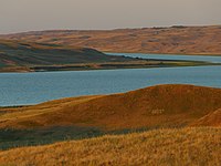 South Saskatchewan River at Cabri Regional Park | |
 Location of the RM of Riverside No. 168 in Saskatchewan | |
| Coordinates: 50°41′24″N 108°16′41″W / 50.690°N 108.278°WCoordinates: 50°41′24″N 108°16′41″W / 50.690°N 108.278°W[1] | |
| Country | Canada |
| Province | Saskatchewan |
| Census division | 8 |
| SARM division | 3 |
| Formed[2] | January 1, 1913 |
| Government | |
| • Reeve | Richard Bye |
| • Governing body | RM of Riverside No. 168 Council |
| • Administrator | Brandi Prentice |
| • Office location | Pennant |
| Area (2016)[4] | |
| • Land | 1,298.39 km2 (501.31 sq mi) |
| Population (2016)[4] | |
| • Total | 477 |
| • Density | 0.4/km2 (1/sq mi) |
| Time zone | CST |
| • Summer (DST) | CST |
| Area code(s) | 306 and 639 |


The Rural Municipality of Riverside No. 168 (2016 population: 477) is a rural municipality (RM) in the Canadian province of Saskatchewan within Census Division No. 8 and SARM Division No. 3.
History[]
The RM of Riverside No. 168 incorporated as a rural municipality on January 1, 1913.[2]
- Historical properties
There is one historical building located within the RM.
- St. John's Norwegian Lutheran Church - (Also called St. John's Lutheran Church and Cemetery) the building was erected in 1919 by Norwegian pioneers to the area. The site is located 15 km south of Cabri[5]
Geography[]
The north boundary of the RM is one of the arms of Lake Diefenbaker.
Communities and localities[]
The following urban municipalities are surrounded by the RM.
- Towns
- Cabri
- Villages
The following unincorporated communities are within the RM.
- Localities
Demographics[]
In the 2016 Census of Population conducted by Statistics Canada, the RM of Riverside No. 168 recorded a population of 477 living in 176 of its 205 total private dwellings, a -2.7% change from its 2011 population of 490. With a land area of 1,298.39 km2 (501.31 sq mi), it had a population density of 0.4/km2 (1.0/sq mi) in 2016.[4]
In the 2011 Census of Population, the RM of Riverside No. 168 recorded a population of 490, a -4.1% change from its 2006 population of 511. With a land area of 1,298.39 km2 (501.31 sq mi), it had a population density of 0.4/km2 (1.0/sq mi) in 2011.[8]
Government[]
The RM of Riverside No. 168 is governed by an elected municipal council and an appointed administrator that meets on the second Tuesday of every month.[3] The reeve of the RM is Richard Bye while its administrator is Brandi Prentice.[3] The RM's office is located in Pennant.[3]
Transportation[]
References[]
- ^ "Pre-packaged CSV files - CGN, Canada/Province/Territory (cgn_sk_csv_eng.zip)". Government of Canada. July 24, 2019. Retrieved May 23, 2020.
- ^ a b "Rural Municipality Incorporations (Alphabetical)". Saskatchewan Ministry of Municipal Affairs. Archived from the original on April 21, 2011. Retrieved May 9, 2020.
- ^ a b c d "Municipality Details: RM of Riverside No. 168". Government of Saskatchewan. Retrieved May 21, 2020.
- ^ a b c "Population and dwelling counts, for Canada, provinces and territories, and census subdivisions (municipalities), 2016 and 2011 censuses – 100% data (Saskatchewan)". Statistics Canada. February 8, 2017. Retrieved May 1, 2020.
- ^ St. John's Norwegian Lutheran Church
- ^ "Saskatchewan Census Population" (PDF). Saskatchewan Bureau of Statistics. Archived from the original (PDF) on September 24, 2015. Retrieved May 9, 2020.
- ^ "Saskatchewan Census Population". Saskatchewan Bureau of Statistics. Retrieved May 9, 2020.
- ^ "Population and dwelling counts, for Canada, provinces and territories, and census subdivisions (municipalities), 2011 and 2006 censuses (Saskatchewan)". Statistics Canada. June 3, 2019. Retrieved May 1, 2020.
| Subdivisions | |
|---|---|
| Communities |
|
| Cities |
|
| Rural municipalities |
|
| Topics |
|
| |
Division No. 8, Saskatchewan | |||||||
|---|---|---|---|---|---|---|---|
| Cities |
|  | |||||
| Towns | |||||||
| Villages |
| ||||||
| Rural municipalities |
| ||||||
| Unincorporated communities |
| ||||||
- Riverside No. 168, Saskatchewan
- Rural municipalities in Saskatchewan