Gisborne Central
Gisborne Central | |
|---|---|
 Wi Pere Monument | |
 | |
| Country | New Zealand |
| City | Gisborne |
| Electoral ward | Gisborne |
| Population (2018)[1] | |
| • Total | 300 |
| Te Hapara | Whataupoko | |
|
|
||
| Awapuni | Victoria | Kaiti |
Gisborne Central is the central business district and central suburb of Gisborne, in the Gisborne District of New Zealand's North Island. It is located east of Elgin, south of Whataupoko and west of Kaiti.[2]
Demographics[]
| Year | Pop. | ±% p.a. |
|---|---|---|
| 2006 | 267 | — |
| 2013 | 306 | +1.97% |
| 2018 | 300 | −0.40% |
| align-centre | — | |
| Source: [1] | ||
Gisborne Central had a population of 300 at the 2018 New Zealand census, a decrease of 6 people (-2.0%) since the 2013 census, and an increase of 33 people (12.4%) since the 2006 census. There were 153 households. There were 156 males and 144 females, giving a sex ratio of 1.08 males per female. The median age was 44.3 years (compared with 37.4 years nationally), with 30 people (10.0%) aged under 15 years, 66 (22.0%) aged 15 to 29, 156 (52.0%) aged 30 to 64, and 54 (18.0%) aged 65 or older.
Ethnicities were 58.0% European/Pākehā, 42.0% Māori, 4.0% Pacific peoples, 10.0% Asian, and 1.0% other ethnicities (totals add to more than 100% since people could identify with multiple ethnicities).
The proportion of people born overseas was 24.0%, compared with 27.1% nationally.
Although some people objected to giving their religion, 40.0% had no religion, 45.0% were Christian, 1.0% were Hindu, 1.0% were Buddhist and 6.0% had other religions.
Of those at least 15 years old, 42 (15.6%) people had a bachelor or higher degree, and 42 (15.6%) people had no formal qualifications. The median income was $29,600, compared with $31,800 nationally. The employment status of those at least 15 was that 150 (55.6%) people were employed full-time, 39 (14.4%) were part-time, and 12 (4.4%) were unemployed.[1]
Parks[]
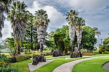
Gisborne Botanical Gardens is a public garden, established in 1874.[3]
Alfred Cox Park is a local park and dog walking area.[3]
Childers Road Reserve[]
Childers Road Reserve is a sports ground.[3]
It was previously the home of Gisborne City AFC and has hosted several national team and professional club football games, including:
- Gisborne City vs Bournemouth 0-4, 1982[4]
- New Zealand vs League of Ireland All Stars 0-0, 1982
- New Zealand vs Gisborne City 4-3, 1985
- New Zealand vs Fiji 3-0, 1985
- New Zealand vs USSR XI 2-4, 1986
- New Zealand vs Dinamo Minsk 0-2, 1987[5]
Education[]
Gisborne Boys' High School is a Year 9-13 single-sex boys' state high school[6][7] with a roll of 789.[8]
Gisborne Intermediate is a Year 7-8 co-educational state intermediate school[9][10] with a roll of 598.[11]
Rolls are as of November 2021.[12]
References[]
- ^ a b c "Statistical area 1 dataset for 2018 Census". Statistics New Zealand. March 2020. Gisborne Central (206800). 2018 Census place summary: Gisborne Central
- ^ Hariss, Gavin. "Gisborne, Gisborne". topomap.co.nz. NZ Topo Map.
- ^ a b c "Gisborne Parks and Reserves". gdc.govt.nz. Gisborne District Council.
- ^ "Bournemouth". rsssf.com.
- ^ "Tables - NZ - 1980s". rsssf.com.
- ^ "Gisborne Boys' High School Official School Website". gisboyshigh.school.nz.
- ^ "Gisborne Boys' High School Education Review Office Report". ero.govt.nz. Education Review Office.
- ^ "Gisborne Boys' High School Ministry of Education School Profile". educationcounts.govt.nz. Ministry of Education.
- ^ "Gisborne Intermediate Official School Website". gisint.co.nz.
- ^ "Gisborne Intermediate Education Review Office Report". ero.govt.nz. Education Review Office.
- ^ "Gisborne Intermediate Ministry of Education School Profile". educationcounts.govt.nz. Ministry of Education.
- ^ "New Zealand Schools Directory". New Zealand Ministry of Education. Retrieved 22 December 2021.
Coordinates: 38°39′59″S 178°01′34″E / 38.666374°S 178.025978°E

- Suburbs of Gisborne, New Zealand
- Central business districts in New Zealand