Te Urewera (protected area)
| Te Urewera | |
|---|---|
IUCN category II (national park) | |
 | |
 Location on map of New Zealand | |
| Location | Hawke's Bay |
| Nearest city | Gisborne, New Zealand |
| Coordinates | 38°45′0″S 177°9′0″E / 38.75000°S 177.15000°ECoordinates: 38°45′0″S 177°9′0″E / 38.75000°S 177.15000°E |
| Area | 2,127 km2 (821 sq mi) |
| Established | 1954 |
| Governing body | Department of Conservation |
| Website | DOC page |

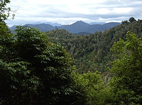
Te Urewera is a protected area and former national park in the area of Te Urewera, near the east coast of New Zealand's North Island. It was established as a national park in 1954 and disestablished as such in 2014, when it was replaced by a legal entity named Te Urewera.[1] It was the largest of four national parks in the North Island and the most isolated rainforest in the region. Covering an area of approximately 2,127 km2, it was in the north of the Hawke's Bay region of the North Island.
SH38 is the only road that leads through the park. The road is unsealed over 74 km.
On 28 July 1954, the catchment areas of Lake Waikaremoana, Lake Waikareiti and other Crown reserves were gazetted as a national park, and by 1957 proposals were well underway to add the rest of the Crown land in Te Urewera north of Ruatāhuna. This proposal was formalised in November 1957 when an additional 1,350 km2 were added. Further additions were made in 1962, 1975 and 1979, with smaller acquisitions and boundary alterations in the intervening period. The lake bed and Māori enclaves were not included in the park gazetting. The Crown had leased the lake bed, which was managed by the Department of Conservation.
Te Urewera is the traditional home of the Tuhoe people. Due to its geographical isolation, it was one of the last regions to be claimed by the British during colonisation in the 19th century. In March 2013, Tuhoe signed a deed of settlement, settling the tribe's claims at the Waitangi Tribunal. Under the deal, Tuhoe will receive $170 million and more control over Te Urewera.[2] Te Urewera ceased to be a national park under the Te Urewera Act 2014,[1][3] but the new entity still meets the International Union for Conservation of Nature criteria for Category II – National Park.[4] The area is now administered by the Te Urewera Board which comprises joint Tūhoe and Crown membership.[1] It is still open to the public and the Department of Conservation will continue to work in Te Urewera and maintain the tracks and facilities in conjunction with the Board.[5] It is the first natural resource in the world to be awarded the same legal rights as a person.[6][7]
See also[]
- Protected areas of New Zealand
References[]
- ^ a b c Ruru, Jacinta (October 2014). "Tūhoe-Crown settlement – Te Urewera Act 2014". Māori Law Review: 16–21. Retrieved 13 December 2015.
- ^ "Govt and Tuhoe sign $170m settlement". Newshub. 22 March 2013. Archived from the original on 24 March 2016.
- ^ Cheng, Derek (25 July 2014). "Tuhoe takes lead in homeland's future". The New Zealand Herald. Retrieved 25 July 2014.
- ^ "Tūhoe Claims Settlement and Te Urewera bills passed". Scoop. 24 July 2014. Retrieved 13 December 2015.
- ^ "Tūhoe claims settlement". Department of Conservation. Retrieved 13 October 2014.
- ^ Gibson, Jacqui (9 June 2020). "The Māori tribe protecting New Zealand's sacred rainforest". BBC Travel. Retrieved 29 September 2021.
- ^ BBC's The Travel Show (29 September 2021). "Te Urewera: New Zealand's 'living' rainforest". BBC Travel. Retrieved 29 September 2021.
External links[]
- Te Urewera, Department of Conservation
- Te Urewera Act 2014
- Journeys in National Parks: Te Urewera, 1987 documentary at NZ On Screen
- Tourism information page
Authority control | |
|---|---|
| General | |
| National libraries | |
- IUCN Category II
- Protected areas established in 1954
- Protected areas disestablished in 2014
- Nature reserves in New Zealand
- Wildlife sanctuaries of New Zealand
- Protected areas of the Hawke's Bay Region
- Former national parks
- Whakatane District
- Ōpōtiki District
- Gisborne District
- Wairoa District