Raukokore
Raukokore | |
|---|---|
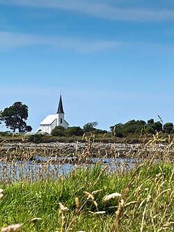 Raukokore's Anglican church | |
 Raukokore | |
| Coordinates: 37°38′38″S 177°52′35″E / 37.64389°S 177.87639°E | |
| Country | |
| Region | Bay of Plenty |
| Territorial authority | Ōpōtiki District |
| Ward | Coast |

Raukokore is a small settlement close to the East Cape in the northeastern North Island of New Zealand. It is located on State Highway 35, close to the mouth of the Raukokore River, 40 kilometres to the west of Hicks Bay.
Raukokore's most notable feature is its Anglican church, Christ Church, a landmark of the East Cape region, which stands isolated close to the shore of Papatea Bay. The church was named as one of the East Cape/Gisborne region's "101 must-do" sites by the New Zealand Automobile Association.[1] The church was designed and built by Duncan Stirling in 1894. Stirling married local Raukokore chief Mihi Kōtukutuku in the church in 1896. The church is listed as a Category 1 Historic Place by Heritage New Zealand.[2]
Raukokore is administered by the Ōpōtiki District Council.
Marae[]
The settlement is in the rohe of the iwi of Te Whānau-ā-Apanui and has two marae affiliated with local hapū. Te Maru o Hinemaka Marae and Pararaki meeting house is affiliated with Te Whānau a Pararaki. Wairūrū Marae and Hinemahuru or Mihi Kōtukutuko meeting house is affiliated with Te Whānau a Maruhaeremuri.[3][4]
In October 2020, the Government committed $205,700 from the Provincial Growth Fund to develop Wairūrū Marae, creating 8 jobs.[5]
Notable people[]
- Taika Waititi - Academy Award-winning filmmaker and actor
References[]
- ^ "Raukokore Church". aatravel.co.nz. New Zealand Automobile Association.
- ^ "Christ Church, Raukokore". heritage.org.nz. Heritage New Zealand.
- ^ "Te Kāhui Māngai directory". tkm.govt.nz. Te Puni Kōkiri.
- ^ "Māori Maps". maorimaps.com. Te Potiki National Trust.
- ^ "Marae Announcements" (Excel). growregions.govt.nz. Provincial Growth Fund. 9 October 2020.
External links[]
Coordinates: 37°38′38″S 177°52′35″E / 37.644°S 177.8764°E
This Bay of Plenty geography article is a stub. You can help Wikipedia by . |
- Ōpōtiki District
- Populated places in the Bay of Plenty Region
- Bay of Plenty Region geography stubs