Gladbrook, Iowa
Gladbrook, Iowa | |
|---|---|
 Location of Gladbrook, Iowa | |
| Coordinates: 42°11′6″N 92°42′53″W / 42.18500°N 92.71472°WCoordinates: 42°11′6″N 92°42′53″W / 42.18500°N 92.71472°W | |
| Country | |
| State | |
| County | Tama |
| Area | |
| • Total | 0.70 sq mi (1.81 km2) |
| • Land | 0.70 sq mi (1.81 km2) |
| • Water | 0.00 sq mi (0.00 km2) |
| Elevation | 974 ft (297 m) |
| Population | |
| • Total | 799 |
| • Density | 1,141.43/sq mi (441.44/km2) |
| Time zone | UTC-6 (Central (CST)) |
| • Summer (DST) | UTC-5 (CDT) |
| ZIP code | 50635 |
| Area code(s) | 641 |
| FIPS code | 19-31035 |
| GNIS feature ID | 0456914 |

Gladbrook is a city in Tama County, Iowa, United States. The population was 799 at the time of the 2020 census.[2]
History[]
A post office called Gladbrook has been in operation since 1880.[3] The name Gladbrook was coined by a railroad official.[4]

On March 21, 1910, the Green Mountain train wreck occurred between Gladbrook and Green Mountain, in which a derailment killed more than fifty people riding on the Chicago, Rock Island and Pacific Railroad line.[5]
Geography[]
Gladbrook is located at 42°11′6″N 92°42′53″W / 42.18500°N 92.71472°W (42.184995, -92.714588).[6]
According to the United States Census Bureau, the city has a total area of 0.70 square miles (1.81 km2), all land.[7]
Demographics[]
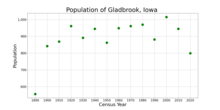
| Year | Pop. | ±% |
|---|---|---|
| 1890 | 556 | — |
| 1900 | 842 | +51.4% |
| 1910 | 869 | +3.2% |
| 1920 | 961 | +10.6% |
| 1930 | 891 | −7.3% |
| 1940 | 945 | +6.1% |
| 1950 | 862 | −8.8% |
| 1960 | 949 | +10.1% |
| 1970 | 961 | +1.3% |
| 1980 | 970 | +0.9% |
| 1990 | 881 | −9.2% |
| 2000 | 1,015 | +15.2% |
| 2010 | 945 | −6.9% |
| 2020 | 799 | −15.4% |
| Source:"U.S. Census website". United States Census Bureau. Retrieved 2020-03-28. and Iowa Data Center Source: | ||
2010 census[]
As of the census[9] of 2010, there were 945 people, 410 households, and 251 families living in the city. The population density was 1,350.0 inhabitants per square mile (521.2/km2). There were 467 housing units at an average density of 667.1 per square mile (257.6/km2). The racial makeup of the city was 98.8% White, 0.5% from other races, and 0.6% from two or more races. Hispanic or Latino of any race were 1.0% of the population.
There were 410 households, of which 25.1% had children under the age of 18 living with them, 50.7% were married couples living together, 7.1% had a female householder with no husband present, 3.4% had a male householder with no wife present, and 38.8% were non-families. 33.9% of all households were made up of individuals, and 21.2% had someone living alone who was 65 years of age or older. The average household size was 2.19 and the average family size was 2.78.
The median age in the city was 47.2 years. 20.2% of residents were under the age of 18; 6.1% were between the ages of 18 and 24; 20.7% were from 25 to 44; 25.7% were from 45 to 64; and 27.3% were 65 years of age or older. The gender makeup of the city was 45.3% male and 54.7% female.
2000 census[]
As of the census[10] of 2000, there were 1,015 people, 408 households, and 263 families living in the city. The population density was 1,456.9 people per square mile (559.8/km2). There were 437 housing units at an average density of 627.3 per square mile (241.0/km2). The racial makeup of the city was 98.82% White, 0.10% African American, 0.49% Native American, 0.10% from other races, and 0.49% from two or more races. Hispanic or Latino of any race were 0.89% of the population.
There were 408 households, out of which 29.7% had children under the age of 18 living with them, 52.7% were married couples living together, 8.3% had a female householder with no husband present, and 35.3% were non-families. 31.1% of all households were made up of individuals, and 21.3% had someone living alone who was 65 years of age or older. The average household size was 2.35 and the average family size was 2.91.
In the city, the population was spread out, with 24.9% under the age of 18, 5.9% from 18 to 24, 24.2% from 25 to 44, 16.9% from 45 to 64, and 28.0% who were 65 years of age or older. The median age was 42 years. For every 100 females, there were 79.3 males under 18. For every 100 females age 18 and over, there were 79.7 males.
The median income for a household in the city was $38,167, and the median income for a family was $41,797. Males had a median income of $34,028 versus $21,161 for females. The per capita income for the city was $18,484. About 4.2% of families and 6.3% of the population were below the poverty line, including 11.3% of those under age 18 and 4.3% of those age 65 or over.
Arts and culture[]
Annual cultural events[]
The Gladbrook Corn Carnival is an annual celebration in Gladbrook that attracts several thousands of visitors per year. It has been held since 1922. It is generally held the last weekend of June with a variety of events held from Thursday through Sunday.
Museums[]
Gladbrook is the home of the Matchstick Marvels Museum. This museum holds large creations, built by Patrick Acton, that are made out of matchsticks. Many of his creations are displayed in Ripley Believe It or Not Museums.[11]
Parks and recreation[]
Gladbrook is host to a movie theater featuring $3.00 and $4.00 movies, a bowling alley, a 24-hour fitness center, a bike and walking trail and an indoor swimming pool.
Union Grove Park[]
Union Grove State Park is located three miles south of Gladbrook. It features a public beach, several picnic areas, public fishing, campgrounds, and short hiking trails.
Education[]
The city is served by the Gladbrook–Reinbeck Community School District;[12] the city was served by the Gladbrook Community School District until it consolidated on July 1, 1988.[13] Students attend school in nearby Reinbeck. Previously there was an elementary and middle school in Gladbrook, but it closed in 2015.[14]
Notable person[]
- Clifford Berry; helped John Vincent Atanasoff create the first digital electronic computer in 1939, the Atanasoff–Berry Computer at Iowa State
References[]
- ^ "2019 U.S. Gazetteer Files". United States Census Bureau. Retrieved July 17, 2020.
- ^ Jump up to: a b c "2020 Census State Redistricting Data". census.gov. United states Census Bureau. Retrieved August 12, 2021.
- ^ "Tama County". Jim Forte Postal History. Retrieved March 18, 2015.
- ^ Chicago and North Western Railway Company (1908). A History of the Origin of the Place Names Connected with the Chicago & North Western and Chicago, St. Paul, Minneapolis & Omaha Railways. p. 77.
- ^ "Fatal train wreck 100 years ago". Archived from the original on 2012-02-24. Retrieved 2010-06-22.
- ^ "US Gazetteer files: 2010, 2000, and 1990". United States Census Bureau. 2011-02-12. Retrieved 2011-04-23.
- ^ "US Gazetteer files 2010". United States Census Bureau. Archived from the original on 2012-01-25. Retrieved 2012-05-11.
- ^ "Census of Population and Housing". Census.gov. Retrieved June 4, 2015.
- ^ "U.S. Census website". United States Census Bureau. Retrieved 2012-05-11.
- ^ "U.S. Census website". United States Census Bureau. Retrieved 2008-01-31.
- ^ Matschstick Marvels: Museum Archived 2007-08-09 at the Wayback Machine, Matchstick Marvels. Accessed 2007-08-16.
- ^ "Gladbrook-Reinbeck." Iowa Department of Education. Retrieved on July 15, 2018.
- ^ "REORGANIZATION & DISSOLUTION ACTIONS SINCE 1965-66." Iowa Department of Education. Retrieved on July 20, 2018.
- ^ "Proposal to dissolve eastern Iowa school district fails". Associated Press at Des Moines Register. 2017-09-13. Retrieved 2018-07-15.
External links[]
| hide Municipalities and communities of Tama County, Iowa, United States | ||
|---|---|---|
| Cities | ||
| Townships | ||
| Unincorporated communities | ||
| Indian reservation | ||
| Footnotes | ‡This populated place also has portions in an adjacent county or counties | |
| ||
- Cities in Iowa
- Cities in Tama County, Iowa