Goes
Goes | |
|---|---|
City and municipality | |
 Harbour of Goes | |
 Flag  Coat of arms | |
 Location in Zeeland | |
| Coordinates: 51°30′N 3°53′E / 51.500°N 3.883°ECoordinates: 51°30′N 3°53′E / 51.500°N 3.883°E | |
| Country | Netherlands |
| Province | Zeeland |
| Government | |
| • Body | Municipal council |
| • Mayor | (PvdA) |
| Area | |
| • Total | 101.92 km2 (39.35 sq mi) |
| • Land | 92.58 km2 (35.75 sq mi) |
| • Water | 9.34 km2 (3.61 sq mi) |
| Elevation | −1 m (−3 ft) |
| Population (January 2019)[4] | |
| • Total | 37,653 |
| • Density | 407/km2 (1,050/sq mi) |
| Demonym(s) | Goesenaar |
| Time zone | UTC+1 (CET) |
| • Summer (DST) | UTC+2 (CEST) |
| Postcode | 4460–4483 |
| Area code | 0113 |
| Website | www |

Goes (Dutch pronunciation: [ɣus] (![]() listen)) is a city and municipality in the southwestern Netherlands on Zuid-Beveland, in the province of Zeeland. The city of Goes has approximately 27,000 residents.
listen)) is a city and municipality in the southwestern Netherlands on Zuid-Beveland, in the province of Zeeland. The city of Goes has approximately 27,000 residents.
History[]

Goes was founded in the 10th century on the edge of a creek: de Korte Gos (the Short Gos). The village grew fast, and in the early 12th century it had a market square and a church devoted to Mary Magdalene. In 1405 Goes received city rights from William, Duke of Bavaria, by his right as count of Holland, and in 1417 it was allowed to build town walls. The prosperity of the city was based upon the cloth industry and the production of salt. In the 16th century Goes declined. Its connection to the sea silted up and in 1554 a large fire destroyed part of the city.
In Autumn 1572, during the course of the Eighty Years' War, Goes, in the Spanish Netherlands, was besieged by Dutch forces with the support of English troops. The siege was relieved in October 1572 by Spanish Tercios, who waded across the Scheldt to attack the besieging forces. In 1577 the Spanish soldiers who occupied Goes were driven out by Prince Maurits of Nassau. The prince built a defence wall around Goes, which is still partly standing. From the 17th century Goes did not play an important role, except as an agricultural centre. In 1868 a railway was constructed through it, but this did not lead to industrialisation. Agriculture remains the most important economic activity.
Although the Netherlands were neutral in the First World War, seven bombs hit Goes and Kloetinge, due to an error by a British airplane. A house in Magdalenastreet in Goes was destroyed and one person killed. Goes did not suffer extensive damage during the Second World War, but was under German occupation until 1944.
Goes did not experience much population growth until the 1970s and 1980s. Then, the city grew fast because of new districts like Goese Meer, Oostmolenpark, Overzuid and Ouverture being constructed. Goes is now the fourth largest economic centre in Zeeland. New districts are in preparation, amongst them Goese Schans, Mannee and Aria, where 3,000 new houses are to be built.
Population centers[]
Topography[]

Dutch Topographic map of Goes (town), Sept. 2014.
Districts[]
- Centre Goes
- West Goes
- New West
- East Goes
- Noordhoek
- Goese Meer
- Goese Polder
- South Goes
- Overzuid
- Ouverture
- De Goese Poort (business area)
- De Poel (I, II, III en IV, business area)
- Klein Frankrijk (business area)
- Marconi (business area)
- Aria (developing)
- Mannee (developing)
- Goese Schans (developing)
International relations[]
Twin towns — sister cities[]

Goes is twinned with:[5]
Transport[]
Railway Station: Goes
On the railway line between Vlissingen and Roosendaal.
Notable people[]

Public thinking & Public Service[]
- Cornelis Caesar (ca.1610 in Goes – 1657) a Dutch merchant and Governor of Formosa 1653/56
- C. H. D. Buys Ballot (1817 in Kloetinge – 1890) a Dutch chemist and meteorologist, invented Buys Ballot's law
- Isaäc Dignus Fransen van de Putte (1822 in Goes – 1902) a Dutch politician
- Jacob Adriaan de Wilde (1879 in Goes – 1956) a Dutch politician and jurist
- Leendert Ginjaar (1928 – 2003 in Goes) a Dutch politician and chemist
- Bas van Fraassen (born 1941 in Goes) a Dutch-American philosopher, partic. philosophy of science
- Albert J.R. Heck (born 1964 in Goes) a Dutch scientist and academic, partic. mass spectrometry and proteomics
- Katinka Simonse (born 1979 in Goes) known as Tinkebell, a controversial campaigner on animal issues
The Arts[]

- Willem Eversdijck (ca.1620 in Goes - 1671) a Dutch Golden Age painter
- Pieter Peutemans (1641 in Goes – 1698) a Dutch Golden Age painter.
- Pieter Adriaan Jacobus Moojen (1879 in Kloetinge - 1955) a Netherlands-Indies architect, painter and writer
- Leo van Doeselaar (born 1954 in Goes) a Dutch classical organist and conductor
- Adriaan Luteijn (born 1964 in 's Heer Arendskerke) a freelance Dutch choreographer
- Boudewijn Vincent Bonebakker (born 1968 in Goes) and Frank Harthoorn, guitarists of Gorefest
Sport[]
- Myrna Veenstra (born 1975 in Goes) a former field hockey player, bronze medallist at the 2000 Summer Olympics
- Martijn Dieleman (born 1979 in Goes) a former Dutch male volleyball player, competed at the 2000 Summer Olympics
- Lesley Pattinama Kerkhove (born 1991 in Spijkenisse) a Dutch tennis player
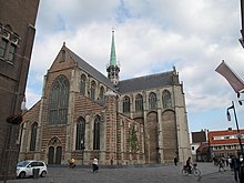
Gallery[]
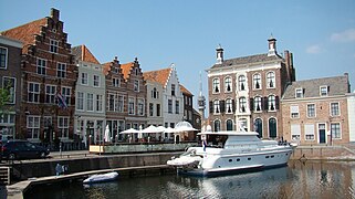
Goes olden haavn
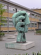
Beeld Bergweg
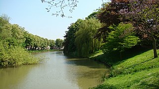
De veste (canal) in Goes

Goese Golf Clubhuis


References[]
- ^ "Samenstelling B&W" [Members of the board of mayor and aldermen] (in Dutch). Gemeente Goes. Archived from the original on 13 December 2013. Retrieved 10 December 2013.
- ^ "Kerncijfers wijken en buurten 2020" [Key figures for neighbourhoods 2020]. StatLine (in Dutch). CBS. 24 July 2020. Retrieved 19 September 2020.
- ^ "Postcodetool for 4461GE". Actueel Hoogtebestand Nederland (in Dutch). Het Waterschapshuis. Archived from the original on 21 September 2013. Retrieved 8 December 2013.
- ^ "Bevolkingsontwikkeling; regio per maand" [Population growth; regions per month]. CBS Statline (in Dutch). CBS. 1 January 2019. Retrieved 1 January 2019.
- ^ "Delegatie uit zusterstad Panevežys brengt bezoek aan Goes". pzc.nl (in Dutch). PZC. 2018-06-04. Retrieved 2019-10-22.
External links[]
| Wikivoyage has a travel guide for Goes. |
 Media related to Goes (municipality) at Wikimedia Commons
- Official website (in Dutch)
| show Places adjacent to Goes |
|---|

| show Authority control |
|---|
- Goes
- Municipalities of Zeeland
- Populated places in Zeeland
- Zuid-Beveland