God's Bridge
| God's Bridge | |
|---|---|
 The Pennine Way crossing the River Greta at God's Bridge | |
 Location of God's Bridge SSSI, Co Durham | |
| Location | County Durham, North East, England |
| Coordinates | 54°30′33″N 2°4′2″W / 54.50917°N 2.06722°WCoordinates: 54°30′33″N 2°4′2″W / 54.50917°N 2.06722°W |
| Area | 9.3 ha (23 acres) |
| Established | 1986 |
| Governing body | Natural England |
| Website | Map of site |

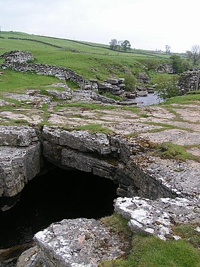
God's Bridge is a Site of Special Scientific Interest in the County Durham district of south-west County Durham, England. It is a natural limestone bridge over the River Greta, just over 3 km upstream from the village of Bowes.
The bridge was formed by a process of cave development in the limestone beneath the river bed and is the best example in Britain of a natural bridge formed in this way. The SSSI covers a portion of the river above and below the bridge where shallow cave development by solutional activity is still taking place.[1]
The Pennine Way crosses the River Greta at God's Bridge.
Yorkshire Dales[]

A similar formation on the River Doe near Chapel-le-Dale in the Yorkshire Dales has the same name.[2]
References[]
- ^ "God's Bridge" (PDF). English Nature. 1986. Archived from the original (PDF) on 22 June 2011. Retrieved 20 July 2010.
- ^ OL2 Yorkshire Dales Southern and western areas (Map). 1:25000. Explorer. Ordnance Survey. Retrieved 3 May 2013.
Categories:
- Sites of Special Scientific Interest in County Durham
- Natural arches of England
- Bowes