Golo (river)
| Golo | |
|---|---|
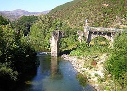 old Golo bridge near Castello-di-Rostino | |
 | |
| Location | |
| Country | France |
| Physical characteristics | |
| Source | |
| • location | central Corsica |
| Mouth | |
• location | Tyrrhenian Sea |
• coordinates | 42°31′23″N 9°32′5″E / 42.52306°N 9.53472°ECoordinates: 42°31′23″N 9°32′5″E / 42.52306°N 9.53472°E |
| Length | 89.4 km (55.6 mi) |

The Golo (Corsican: Golu) is the longest (89.4 kilometres (55.6 mi)) river on the island of Corsica, France.[1] Its source is in the mountainous middle of the island, south of Monte Cinto. It flows generally northeast, through Calacuccia and Ponte-Leccia, and ends in the Tyrrhenian Sea approximately 20 km south of Bastia, near the Bastia - Poretta Airport. Its entire course is in the Haute-Corse département.
References[]
External links[]
| hide Authority control | |
|---|---|
| General | |
| National libraries | |
| Other |
|
This Corsica geographical article is a stub. You can help Wikipedia by . |
Categories:
- Rivers of Corsica
- Rivers of Haute-Corse
- Drainage basins of the Tyrrhenian Sea
- Rivers of France
- Corsica geography stubs
- France river stubs