Golovnin
| Golovnin | |
|---|---|
 | |
| Highest point | |
| Elevation | 535 m (1,755 ft) |
| Coordinates | 43°50′28″N 145°30′32″E / 43.841°N 145.509°E |
| Geography | |
 Golovnin Golovnin in Russian Far East | |
| Location | Kunashir, Kuril Islands, Russia/Japan |
| Geology | |
| Mountain type | Lava domes / Caldera |
| Last eruption | 1848 |

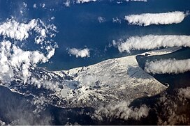
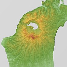
Golovnin (Japanese: 泊山, Tomari-yama; Russian: Головнин) is a caldera located in the southern part of Kunashir Island, Kuril Islands, Russia. It is the southernmost volcano of the Kuril Islands.
It is named after Russian explorer Vasily Golovnin.
Golovnin Volcano
See also[]
References[]
| hide | |
|---|---|
| Islands | |
| Volcanoes |
|
| Other geographical features | |
| Cities and towns | |
| Events |
|
| People | |
This Sakhalin Oblast location article is a stub. You can help Wikipedia by . |
Categories:
- Kunashir Island
- Calderas of Russia
- Calderas of Japan
- Active volcanoes
- Volcanoes of the Kuril Islands
- Sakhalin Oblast geography stubs