Habomai Islands
| Disputed islands Other names: Russian: Малые Курилы; Japanese: 歯舞群島, romanized: Habomai guntō | |
|---|---|
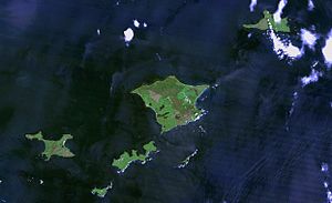 Khabomai Rocks from space | |
| Geography | |
 | |
| Location | Pacific Ocean |
| Coordinates | 43°30′N 146°8′E / 43.500°N 146.133°E |
| Archipelago | Kuril Islands |
| Total islands | 10 + several rocks |
| Area | 100 km2 |
| Administered by | |
| Federal subject | Sakhalin Oblast |
| District | Yuzhno-Kurilsky |
| Claimed by | |
| Prefecture | Hokkaido |
| Subprefecture | Nemuro |
| Demographics | |
| Population | 117 |

The Habomai Islands (Russian: Хабомаи (Khabomai), Japanese: 歯舞群島 (Habomai guntō) or 歯舞諸島 (Habomai shotō) are a group of islets in the southernmost Kuril Islands. They are currently under Russian administration, but together with Iturup (Etorofu), Kunashir (Kunashiri), and Shikotan are claimed by Japan.
History[]


In 1732 it was mapped during the Russian Great Eastern Expedition.
The Treaty of Shimoda, signed by Russia and Japan in 1855, gave Japan ownership of Iturup, Kunashir, Shikotan, and the Habomai Islands.[1]
The Habomai Islands were occupied by Soviet forces in the last few days of World War II. The islands were eventually annexed by the Soviet Union, which deported all the island residents to Japan.[1] Moscow claimed the islands as part of a war-time agreement between the Allies (Yalta Agreement), which provided for the transfer of the Chishima (Kurile) Islands to the USSR in return for its participation in the Pacific War. However, Japan maintains that the Habomai Islands are not part of the Kuriles and are in fact part of Hokkaido prefecture. On May 26, 1955, the United States submitted an application for proceedings against the Soviet Union. As part of the proceedings, the United States questioned the validity of the Soviet Union's claim to the Habomai Islands.[2]
In 1956, after difficult negotiations, the Soviet Union agreed to cede the Habomai to Japan, along with Shikotan, after the conclusion of a peace treaty between the two countries.[3] As the treaty was never concluded, the islands remained under Soviet jurisdiction. However, the promise of a two-island solution (for the purpose of simplicity, the Habomai rocks count as one island) has been renewed in the Soviet-Japanese, and later Russo-Japanese negotiations.
Formerly home to a Japanese fishing community, the islands are now uninhabited except for the Russian border guard outpost.

List of islands[]
| Island | Japanese name | Russian name | Ainu transcription(s) | Area km2 |
Highest point m |
Latitude N | Longitude E | Distance from Cape Nosappu[4] km |
|---|---|---|---|---|---|---|---|---|
| Shikotan | 色丹島 しこたんとう Shikotan tō |
Остров Шикотан | si-kotan (Big village) | 255 | 412.6 | 43°47' | 146°44' | 73.3 |
| (Habomai islands are shown below.) Shikotan channel | ||||||||
| 海馬島 かいばじま、とどじま Kaibajima, Todojima |
Остров Осколки | todo-mosir (Steller sea lion island) | 1.5 | 38 | 43°34' | 146°24' | ||
| 多楽島 たらくとう Taraku tō |
Остров Полонского | torar-uk (Take in the strap) | 11.69 | 25 | 43°37' | 146°19' | 45.5 | |
| カブ島 かぶとう Kabu tō |
Скала Чайка | |||||||
| カナクソ岩 かなくそいわ Kanakuso iwa |
Скала Пещерная | |||||||
| カブト島 かぶととう Kabuto tō |
Острова Шишки | |||||||
Taraku channel | ||||||||
| Zelyony | 志発島 しぼつとう Shibotsu tō |
Остров Зелёный | sipe-op (A place where a shoal of Chum salmon) | 58.3 | 45 | 43°29' | 146°09' | 25.5 |
Shibotsu channel | ||||||||
| 春苅島 はるかるとう Harukaru tō |
Острова Дёмина | haru-kar-kotan (Village of harvesting Cardiocrinum cordatum bulbs) | 2 | 34 | 43°25' | 146°10' | ||
| Yuri | 勇留島 ゆりとう Yuri tō |
Остров Юрий | urir (Cormorant island) | 10 | 43°25' | 146°04' | 16.6 | |
| Anuchina | 秋勇留島 あきゆりとう Akiyuri tō |
Остров Анучина | aki-urir (Yuri's young brother) | 5 | 33 | 43°21' | 146°00' | 13.7 |
| 水晶島 すいしょうとう Suishō tō |
Остров Танфильева | si-so (Big bare rock) | 21 | 15 | 43°26' | 145°55' | 7.2 | |
Sovetskiy channel | ||||||||
| 萌茂尻島 もえもしりとう Moemoshiri tō |
Остров Сторожевой | moi-mosir (A calm island) | 0.07 | 11.8 | 43°23' | 145°53' | 6.0 | |
| オドケ島 おどけとう Odoke tō |
Остров Рифовый | 0.001 | 3.6 | 43°23' | 145°52' | |||
| 貝殻島 かいがらじま Kaigarajima |
Остров Сигнальный | kay-ka-ra-i (Low thing above the wave) | 43°23' | 145°51' | 3.7 | |||
| Cape Nosappu, Hokkaido | ||||||||
References[]
- ^ Jump up to: a b "Kuril islands dispute between Russia and Japan". BBC. Retrieved 18 May 2015.
- ^ "October 7, 1952 Incident (Habomai Islands) : Application by the United States to the International Court of Justice, May 26, 1955". Yale Law School. Retrieved 18 May 2015.
- ^ "Texts of Soviet–Japanese Statements; Peace Declaration Trade Protocol." The New York Times, page 2, October 20, 1956.
Subtitle: "Moscow, October 19. (UP) – Following are the texts of a Soviet–Japanese peace declaration and of a trade protocol between the two countries, signed here today, in unofficial translation from the Russian". Quote:"...The U.S.S.R. and Japan have agreed to continue, after the establishment of normal diplomatic relations between them, negotiations for the conclusion of a peace treaty. Hereby, the U.S.S.R., in response to the desires of Japan and taking into consideration the interest of the Japanese state, agrees to hand over to Japan the Habomai and the Shikotan Islands, provided that the actual changing over to Japan of these islands will be carried out after the conclusion of a peace treaty..." - ^ 北方領土の姿 北方対策本部 - 内閣府 (in Japanese)
External links[]
| hide | |
|---|---|
| Islands | |
| Volcanoes |
|
| Other geographical features | |
| Cities and towns | |
| Events |
|
| People | |
- Japan–Soviet Union relations
- Southern Kuriles