Nemuro Subprefecture
Nemuro Subprefecture
根室振興局 | |
|---|---|
| Nemuro-shinkō-kyoku | |
 | |
| Prefecture | Hokkaido |
| Capital | Nemuro |
| Area | |
| • Total | 3,406.23 km2 (1,315.15 sq mi) |
| Population (March 2009) | |
| • Total | 84,035 |
| • Density | 25/km2 (64/sq mi) |
| Website | nemuro.pref.hokkaido.lg.jp |
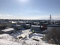
Nemuro City in Hokkaido.
Nemuro (根室振興局, Nemuro-shinkō-kyoku) is a subprefecture of Hokkaido Prefecture, Japan. Japan claims the southern parts of the disputed Kuril Islands (known as the Northern Territories in Japan) as part of this subprefecture.
As of March 2009, the subprefecture has an estimated population of 84,035, and an area of 3406.23 km².
Nakashibetsu Airport, the easternmost airport in Japan, is located in the town of Nakashibetsu, Shibetsu District.
History[]
- November 1897: Nemuro Subprefecture established.
- November 1897: Shana Subprefecture established.
- December 1903: Shana Subprefecture and Nemuro Subprefecture merged.
- August 1945: Soviets occupied the Kuril Islands.
Geography[]

Satellite photo of Hokkaido and the southern Kuril islands (Northern Territories)
Municipalities[]
| Name | Area (km2) | Population | District | Type | Map | |
|---|---|---|---|---|---|---|
| Rōmaji | Kanji | |||||
| 別海町 | 1,320.15 | 15,179 | Notsuke District | Town | ||
| 中標津町 | 684.98 | 24,014 | Shibetsu District | Town | 
| |
| 根室市 | 512.63 | 27,109 | no district | City | 
| |
| 羅臼町 | 397.88 | 5,395 | Menashi District | Town | 
| |
| 標津町 | 624.49 | 5,374 | Shibetsu District | Town | 
| |
Districts in the Northern Territories[]
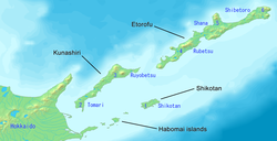
Nemuro Subprefecture is in north eastern Hokkaido. It shows the names of the claimed islands and districts (Northern Territories)
- Also known as the Southern Kuril Islands (administered by Russia, claimed by Japan; see Kuril Islands dispute):
| Name | Area (km2) | Population | District | Type | Map | |
|---|---|---|---|---|---|---|
| Rōmaji | Kanji | |||||
| Rubetsu (Pioner) | 留別村 | 1,442.82 | 2,814 | (Iturup) | Village | |
| (Yuzhno-Kurilsk) | 留夜別村 | 960.27 | 3,401 | (Kunashir) | Village | |
| Shana (Kurilsk) | 紗那村 | 973.3 | 1,426 | Village | ||
| (Rudnaya) | 蘂取村 | 760.5 | 881 | Shibetoro District | Village | |
| Shikotan | 色丹村 | 253.33 | 1,499 | Shikotan District | Village | |
| () | 泊村 | 538.56 | 5,595 | (Kunashir) | Village | |
Districts renounced in San Francisco Treaty[]
Nemuro Subprefecture is blue. The claimed islands and districts (Northern Territories) are grey.
- (Urup)
- (Simushir)
- (Shumshu)
Islands[]
- Habomai Rocks
- Shikotan Island
- Kunashiri
- Etorofu (Iturup)
Mergers[]
External links[]
- Official Website (in Japanese)
Coordinates: 43°19′49″N 145°35′04″E / 43.33038°N 145.584389°E

| show |
|---|
Categories:
- Southern Kuriles
- Subprefectures in Hokkaido