Rumoi Subprefecture
Rumoi Subprefecture
留萌振興局 | |
|---|---|
| Rumoi-shinkōkyoku | |
 Sunset from , Rumoi City | |
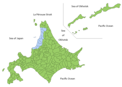 Rumoi Subprefecture in Hokkaido | |
 Rumoi Subprefecture Rumoi Subprefecture in Japan | |
| Coordinates: 43°56′05″N 141°39′21″E / 43.93472°N 141.65583°ECoordinates: 43°56′05″N 141°39′21″E / 43.93472°N 141.65583°E | |
| Country | Japan |
| Prefecture | Hokkaido |
| Capital | Rumoi |
| Area | |
| • Total | 4,019.91 km2 (1,552.10 sq mi) |
| Population (December 2011) | |
| • Total | 52,627 |
| • Density | 13/km2 (34/sq mi) |
| • Summer (DST) | Japan Standard Time (UTC+9) |
| Website | www |


Rumoi Subprefecture (留萌振興局, Rumoi-shinkō-kyoku) is a subprefecture of Hokkaido Prefecture, Japan. As of 2011, it had a population of 52,627 and an area of 4,019.97 square kilometres (1,552.12 sq mi). The population density of the subprefecture, 13 people per km2, is very low compared to the rest of Japan. The population of Rumoi Subprefecture represents 0.96% of the overall population of Hokkaido.[1][2]
Geography[]
Rumoi Subprefecture stretches broadly across the coast of the Sea of Japan in northwestern Hokkaido.
Municipalities[]
| Name | Area (km2) | Population | District | Type | Map | |
|---|---|---|---|---|---|---|
| Rōmaji | Kanji | |||||
| 遠別町 | 590.86 | 2,966 | Teshio District | Town | 
| |
| 羽幌町 | 472.49 | 7,338 | Tomamae District | Town | 
| |
| 増毛町 | 369.64 | 4,634 | Mashike District | Town | 
| |
| 小平町 | 627.29 | 3,277 | Rumoi District | Town | 
| |
| 留萌市 | 297.44 | 22,242 | no district | City | 
| |
| 初山別村 | 280.04 | 1,249 | Tomamae District | Village | 
| |
| 天塩町 | 353.31 | 3,241 | Teshio District | Town | 
| |
| 苫前町 | 454.5 | 3,261 | Tomamae District | Town | 
| |
Mergers[]
Rivers[]
The Rumoi River 44 kilometres (27 mi) flows from Mount Poroshiri in the Hidaka Mountain range to the Sea of Japan.[3]
History[]
was established as part of the administrative reforms of Hokkaido during the Meiji period (1868 – 1912). The capital was moved to Rumoi in 1914, and the subprefecture was renamed to Rumoi Subprefecture in the same year. Toyotomi Town) in Teshio District transferred to Sōya Subprefecture in 1948, and Horonobe was transferred to Sōya Subprefecture in 2010.
Economy[]
The fishing industries dominates the economy of the area, and seafood processing remains a thriving industry.[2]
See also[]
References[]
- ^ 留萌の統計 [Statistics of Rumoi] (in Japanese). Rumoi, Hokkaido: Rumoi Subprefecture. 2012. Retrieved August 10, 2012.
- ^ Jump up to: a b "Rumoi". Encyclopedia of Japan. Tokyo: Shogakukan. 2012. OCLC 56431036. Archived from the original on 2007-08-25. Retrieved 2012-08-08.
- ^ "留萌川". Dijitaru Daijisen (in Japanese). Tokyo: Shogakukan. 2012. OCLC 56431036. Archived from the original on 2007-08-25. Retrieved 2012-08-10.
External links[]
| Wikivoyage has a travel guide for Rumoi Subprefecture. |
- (in Japanese) Official website
| show |
|---|
- Subprefectures in Hokkaido