Gomoa District
Gomoa District | |
|---|---|
Former District | |
 Districts of Central Region | |
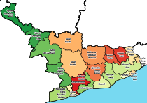
 Gomoa District Location of Gomoa District within Central | |
| Coordinates: 5°16′44.5″N 0°44′23.0″W / 5.279028°N 0.739722°W | |
| Country | |
| Region | |
| Capital | Apam |
| Area | |
| • Total | 891 km2 (344 sq mi) |
| Time zone | UTC+0 (GMT) |
| ISO 3166 code | GH-CP-GO |

Gomoa District is a former district that was located in Central Region, Ghana. Originally created as an ordinary district assembly in 1988. However on 29 February 2008, it was split off into two new districts: Gomoa West District (capital: Apam) and Gomoa East District (capital: Gomoa Afransi). The district assembly was located in the southeast part of Central Region and had Apam as its capital town.
History[]
Gomoa District was mainly inhabited by the Akan-subgroup Fantes. The inhabitants were mainly farmers and fishermen.
Apam was the capital of Gomoa District. The locals however called it Apaa instead of the Apam that others called it. Most of the people living in Apam were engaged in fishing, supplying the land-locked villages surrounding it with fish. There is also a vibrant salt industry in Apam, in which salt is got from the lagoon. There is a secondary school and a hospital that serves the people of Apam and the surrounding areas.
One of the main attractions in Apam is a fort built by the Portuguese, called Fort Patience.
The people of Apam celebrate the "Akwambo" festival. Akwambo basically means "the making of a way". It is celebrated to make the time when their ancestors made their way to Apam.
Sources[]
- "Gomoa District". Statoids.
- District: Gomoa District
References[]
| Metropolitan (1) |
|  |
|---|---|---|
| Municipal (7) |
| |
| Ordinary (14) |
| |
Coordinates: 5°16′44.5″N 0°44′23.0″W / 5.279028°N 0.739722°W
- Central Region (Ghana)
- Districts of the Central Region (Ghana)