Gordon/Barrie Island
Gordon/Barrie Island | |
|---|---|
Municipality (single-tier) | |
| Municipality of Gordon/Barrie Island | |
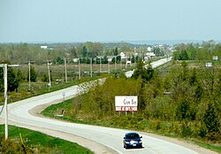 Highway 540 through Gordon | |
 Gordon/Barrie Island | |
| Coordinates: 45°54′N 82°38′W / 45.900°N 82.633°WCoordinates: 45°54′N 82°38′W / 45.900°N 82.633°W | |
| Country | Canada |
| Province | Ontario} |
| District | Manitoulin |
| Formed | January 1, 2009 |
| Government | |
| • Type | Township |
| • Reeve | Lee Hayden |
| • Federal riding | Algoma—Manitoulin—Kapuskasing |
| • Prov. riding | Algoma—Manitoulin |
| Area | |
| • Land | 267.77 km2 (103.39 sq mi) |
| Population (2016)[1] | |
| • Total | 490 |
| • Density | 1.8/km2 (5/sq mi) |
| Time zone | UTC-5 (EST) |
| • Summer (DST) | UTC-4 (EDT) |
| Postal Code | P0P |
| Area code(s) | 705 |
| Website | gordonbarrieisland |


The Municipality of Gordon/Barrie Island is a township in Manitoulin District in north central Ontario, Canada. It was formed on January 1, 2009, upon the amalgamation of the townships of Gordon and Barrie Island.[2]
The township consists of the communities of Advance, Foxey, Ice Lake, Tobacco Lake and Barrie Island. Gordon/Barrie Island also contains three lakes: Nameless Lake, Tobacco Lake and Ice Lake.
Barrie Island[]
Barrie Island (45°55′N 82°40′W / 45.917°N 82.667°W) is about 8 kilometres (5.0 mi) wide, 13 kilometres (8.1 mi) long, and has a surface area of 79 square kilometres (31 sq mi). It is connected to Manitoulin by Highway 540A, which crosses the water via a causeway at the narrowest part of the strait.
The island has a significant summer recreational population.
John Gordon Lane was born on Barrie Island, the Member of Provincial Parliament for Algoma—Manitoulin from 1971 to 1987.
Demographics[]
| 2016 | 2011 | |
|---|---|---|
| Population | 490 (-6.8% from 2011) | 526 (+14.6% from 2006) |
| Land area | 267.77 km2 (103.39 sq mi) | 268.14 km2 (103.53 sq mi) |
| Population density | 1.8/km2 (4.7/sq mi) | 2.0/km2 (5.2/sq mi) |
| Median age | 51.4 (M: 52.4, F: 50.4) | |
| Total private dwellings | 523 | 599 |
| Median household income | $56,960 |
Population trend:[7]
- Population in 2011: 526
- Gordon Township: 491
- Barrie Island Township: 35
- Population in 2006:
- Gordon Township: 412
- Barrie Island Township: 47
- Population in 2001:
- Gordon Township: 473
- Barrie Island Township: 50
- Population in 1996:
- Gordon Township: 470 (adjusted for 2001 boundaries)
- Barrie Island Township: 60
- Population in 1991:
- Barrie Island Township: 75
See also[]
References[]
- ^ a b "Census Profile, 2016 Census: Gordon/Barrie Island, Municipality". Statistics Canada. Retrieved June 20, 2019.
- ^ "Annual changes to census subdivision codes, names and types, between 2006 and 2011, by province and territory, and by year". Standard Geographical Classification (SGC) 2011. Statistics Canada. Retrieved 2012-02-22.
- ^ "2016 Community Profiles". 2016 Canadian Census. Statistics Canada. August 12, 2021. Retrieved 2019-06-20.
- ^ "2011 Community Profiles". 2011 Canadian Census. Statistics Canada. March 21, 2019. Retrieved 2012-02-22.
- ^ "2006 Community Profiles". 2006 Canadian Census. Statistics Canada. August 20, 2019.
- ^ "2001 Community Profiles". 2001 Canadian Census. Statistics Canada. July 18, 2021.
- ^ Statistics Canada: 2001, 2006, 2011 census
External links[]
| Wikimedia Commons has media related to Gordon/Barrie Island. |
Places adjacent to Gordon/Barrie Island | ||||||||||||||||
|---|---|---|---|---|---|---|---|---|---|---|---|---|---|---|---|---|
| ||||||||||||||||
- Municipalities in Manitoulin District
- Municipalities in Ontario
- Single-tier municipalities in Ontario