Manitoulin District
Manitoulin District | |
|---|---|
District | |
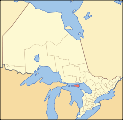 Location of Manitoulin District within Ontario | |
| Coordinates: 45°46′N 82°12′W / 45.767°N 82.200°WCoordinates: 45°46′N 82°12′W / 45.767°N 82.200°W | |
| Country | Canada |
| Province | Ontario |
| Region | Northeastern Ontario |
| Created | 1888 |
| Government | |
| • MP | Carol Hughes |
| • MPP | Michael Mantha |
| Area | |
| • Land | 3,107.12 km2 (1,199.67 sq mi) |
| Population (2016)[1] | |
| • Total | 13,255 |
| • Density | 4.3/km2 (11/sq mi) |
| Time zone | UTC-5 (Eastern (EST)) |
| • Summer (DST) | UTC-4 (EDT) |
| Postal code span | P0P |
| Area code(s) | 705 |
| Seat | Gore Bay |

Manitoulin District is a district in Northeastern Ontario within the Canadian province of Ontario. It was created in 1888 from part of the Algoma District. The district seat is in Gore Bay.
It comprises Manitoulin Island primarily, as well as a number of smaller islands surrounding it, such as Barrie, Cockburn, and Great La Cloche islands. Previously it included the municipality of Killarney on the mainland, until this was transferred to Sudbury District in the late 1990s. Subsequently, more mainland portions were added to Killarney and these, together with Unorganized Mainland Manitoulin District, were also transferred to Sudbury District in 2006, about 1,600 square kilometres (600 sq mi) in all.[2]
Geography[]
The district has an area of 3,107.13 square kilometres (1,199.67 sq mi),[1] making it the smallest district in Ontario. It is located in the northern part of Lake Huron, separated from the mainland by the North Channel to the north and by the Georgian Bay to the east.
Islands included within the district are:[3]
- Barrie Island
- Bedford Island
- Burnt Islands (Big and Northwest)
- Clapperton Island
- Club Island
- Cockburn Island
- Duck Islands (Great, Middle, Outer, and Western)
- East Rous Island
- Fitzwilliam Island
- Goat Island
- Great La Cloche Island
- Greene Island
- Henry Island
- Heywood Island
- Manitoulin Island
- Rabbit Island
- Strawberry Island
- Thibault Island
- Vidal Island
- Wall Island
- Yeo Island
Subdivisions[]
Towns[]
| Name of Town | Population | Ref. |
|---|---|---|
| Gore Bay | 867 | |
| Northeastern Manitoulin and the Islands | 2,706 |
Townships[]
| Name of Township | Population | Ref. |
|---|---|---|
| Assiginack | 1,014 | |
| Billings | 603 | |
| Burpee and Mills | 343 | |
| Central Manitoulin | 2,084 | |
| Cockburn Island | 0 | |
| Gordon/Barrie Island | 490 | |
| Tehkummah | 436 |
Unorganized areas[]
| Name of Area | Population | Ref. |
|---|---|---|
| Manitoulin, Unorganized, Mainland (dissolved in 2006) | 5 | |
Manitoulin, Unorganized, West Part, includes these two geographic townships (each served by its own, separate local services board):
|
168 |
First Nations reserves[]
| Name of Reserve | Population | Ref. |
|---|---|---|
| M'Chigeeng (West Bay) | 939 | |
| Sheguiandah | 154 | |
| Sheshegwaning | 118 | |
| Sucker Creek | 365 | |
| Whitefish River | 487 | |
| Wikwemikong | 2,592 | |
| Zhiibaahaasing (Cockburn Island) | 55 |
Communities[]
- Advance
- Bass Creek
- Bidwell
- Big Lake
- Bowser's Corner
- Britainville
- Burnt Island
- Burpee
- Clover Valley
- Cold Springs
- Cook's Dock
- Dinner Point Depot
- Dryden's Corner
- Eads Bush
- Eagles Nest
- Elizabeth Bay
- Evansville
- Fernlee
- Foxey
- Gibraltar
- Green Bay
- Grimsthorpe
- Hilly Grove
- Honora
- Ice Lake
- Kagawong
- Little Current
- Long Bay
- Manitowaning
- Meldrum Bay
- Michael's Bay
- Mindemoya
- Monument Corner
- Old Spring Bay
- Perivale
- Pleasant Valley
- Poplar
- Providence Bay
- Rockville
- Sandfield
- Sheguiandah
- Silver Water
- The Slash
- Snowville
- South Baymouth
- Spring Bay
- Squirrel Town
- Tobacco Lake
- Tolsmaville
- Turner
- Vanzant's Point
Demographics[]
| 2016 | 2011 | |
|---|---|---|
| Population | 13,255 (1.6% from 2011) | 13,048 (3.3% from 2006) |
| Land area | 3,107.11 km2 (1,199.66 sq mi) | |
| Population density | 4.2/km2 (11/sq mi) | |
| Median age | 46.6 (M: 46.2, F: 47.1) | |
| Total private dwellings | 9,537 | 9281 |
| Median household income |
|
Ethnic groups
|
Religious groups
|
Services[]
Like the other districts of Northern Ontario, the Manitoulin District does not have a county or regional municipality tier of government. All services in the district are provided either by the individual municipalities or directly by the provincial government. Services are provided jointly with the Sudbury District from its district seat in Espanola.
Media[]
The district is served by two weekly community newspapers, the Manitoulin Expositor in Little Current and the Manitoulin West Recorder in Gore Bay; the papers are sister publications both owned and operated by the McCutcheon family.
The district is served by the commercial radio stations CFRM-FM and CHAW-FM, the First Nations community radio station CHYF-FM, and the Elliot Lake-based commercial radio station CKNR-FM. It is otherwise primarily served by media from Sudbury, including the Sudbury Star and CTV Northern Ontario.
Highways[]
King's Highways[]
Secondary Highways[]
- #540
- #540A
- #540B
- #542
- #542A
- #551
See also[]
- List of townships in Ontario
- Manitoulin Streams Improvement Association - A not-for-profit group that rehabilitates streams, rivers, and creeks on Manitoulin Island.
- List of secondary schools in Ontario#Manitoulin District
References[]
- ^ a b c d "2011 Community Profiles". 2011 Canadian Census. Statistics Canada. March 21, 2019. Retrieved 2012-03-19.
- ^ "Annual changes to census subdivision codes, names and types, between 2006 and 2011, by province and territory, and by year". Standard Geographical Classification (SGC) 2011. Statistics Canada. Retrieved 2012-02-22.
- ^ Geomatics Office, Ministry of Transportation (2008). Ontario, Canada, 2008/2009 official road map (2008-2009 ed.). St. Catherines, Ont.: Geomatics Office. ISBN 9781424955435.
- ^ "2016 Community Profiles". 2016 Canadian Census. Statistics Canada. August 12, 2021.
- ^ "2006 Community Profiles". 2006 Canadian Census. Statistics Canada. August 20, 2019.
- ^ "2001 Community Profiles". 2001 Canadian Census. Statistics Canada. July 18, 2021.
External links[]
 Media related to Manitoulin at Wikimedia Commons
- Media related to Cities and towns of Manitoulin District at Wikimedia Commons
- Manitoulin-Sudbury District Services Board
Places adjacent to Manitoulin District | ||||||||||||||||
|---|---|---|---|---|---|---|---|---|---|---|---|---|---|---|---|---|
| ||||||||||||||||
Subdivisions of Ontario | |
|---|---|
| Counties | |
| Districts | |
| Regional municipalities | |
| Single-tier municipalities | |
| Separated municipalities | |
| Regions | |
| |
- Manitoulin District