Perth County, Ontario
Perth County | |
|---|---|
County (upper-tier) | |
| County of Perth | |
 Perth County Court House, Stratford, Ontario | |
|
| |
| Motto(s): Cultivating Opportunity | |
 Location of Perth County | |
| Coordinates: 43°30′N 81°05′W / 43.500°N 81.083°WCoordinates: 43°30′N 81°05′W / 43.500°N 81.083°W | |
| Country | |
| Province | |
| Formed | 1850 |
| County seat | Stratford |
| Municipalities | List
|
| Area | |
| • Land | 2,177.78 km2 (840.85 sq mi) |
| Elevation | 394 m (1,293 ft) |
| Population (2016)[1] | |
| • Total | 38,066 |
| • Urban density | 17.5/km2 (45/sq mi) |
| Time zone | UTC−5 (EST) |
| • Summer (DST) | UTC−4 (EDT) |
| Area code(s) | 519 and 226 |
| Website | www.perthcounty.ca |

Perth County is a county in the Canadian province of Ontario in Southwestern Ontario, 100 kilometres (62 mi) west of Toronto. Its population centres are Listowel, Mitchell and Milverton. The City of Stratford and the Town of St. Marys are within the Perth census division, but are separate from Perth County. Perth County's 2016 population was 38,066.
Municipalities[]
The county comprises four lower-tier municipalities:[2]
- Municipality of North Perth, 2016 population 13,130
- Township of Perth East, 2016 population 12,261
- Municipality of West Perth, 2016 population 8,865
- Township of Perth South, 2016 population 3,810
History[]
Perth County was settled primarily through the efforts of the Canada Company agency which opened a road from the site of Stratford to Goderich. The settlers were almost equal in number as to their origins: English, Irish, Scottish and German. They began arriving in the 1820s but the majority arrived in the 1830s and the 1840s. Most became farmers, and even today, the county is known for mixed farming, dairying and hog production.[3]
This area originally formed part of the Huron District, which was constituted as the United Counties of Huron, Perth and Bruce in 1850.[4] The County of Perth was given its own Provisional Municipal Council at that time,[5] and was separated from the United Counties in 1853.[6]
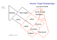
It had 11 original townships.[7] Eight of the townships were laid out as part of the Huron Tract, and three more were surveyed from that part of the crown land known as the Queen's Bush:[3]
| Part of | Township | Area | Opened for settlement | Description |
|---|---|---|---|---|
| Huron Tract | Blanshard | 45,952 acres (72 sq mi; 186 km2) | 1830 | Named for Richard Blanshard, Director of the Canada Company. |
| Downie | 48,342 acres (76 sq mi; 196 km2) | 1830 | Named in honour of Robert Downie, M.P., one of the directors of the Canada Company. | |
| Easthope | 66,758 acres (104 sq mi; 270 km2) | 1830 | Named for Sir John Easthope, M.P. A Director of the Canada Company. In 1843, the townships were divided into North Easthope and South Easthope. | |
| Ellice | 54,520 acres (85 sq mi; 221 km2) | 1830 | Named in honour of Rt. Hon. Edward Ellice, a Canadian-born director of the Canada Company. His father was managing director of the Hudson's Bay Company. | |
| Fullarton | 40,198 acres (63 sq mi; 163 km2) | 1830 | Named for John Fullarton, Director of the Canada Company. | |
| Hibbert | 41,421 acres (65 sq mi; 168 km2) | 1830 | Named in honour of William T. Hibbert, Director of the Canada Company. First settler was Thomas Fox who received 200 acres (0.8 km2) of land from the company on the condition he open an inn for travelers on the Huron Road. | |
| Logan | 53,748 acres (84 sq mi; 218 km2) | 1830 | Named in honour of Hart Logan, Director of the Canada Company and uncle of Sir William E. Logan, the founder of the Canadian Geological Survey. | |
| Queen's Bush | Elma | 67,413 acres (105 sq mi; 273 km2) | 1849 | The first settlers, Samuel Boyd and George Code, came from Lanark County in 1848. Named in honour of Lady Elma Bruce, daughter of James Bruce, 8th Earl of Elgin, Governor-General of Canada. |
| Mornington | 50,087 acres (78 sq mi; 203 km2) | 1845 | Surveyed in 1850. Named in honour of Richard Wellesley, Earl of Mornington, eldest brother of the Duke of Wellington. | |
| Wallace | 50,508 acres (79 sq mi; 204 km2) | 1849 | Named in honour of Thomas, Baron Wallace, vice-president of the British Board of Trade under Lord Goderich in 1820. |
The City of Stratford was formed from parts of Downie, Ellice and Easthope Townships. In 1831 William Sergeant was given a lot by the Canada Company on the condition that he open an inn. In 1832 he erected the first frame building in the region by the Avon River and called it the "Shakespeare Hotel." First purchaser of land was John Sharman (1834), a blacksmith from Bedfordshire, England. His son, Henry, was the first child born within the limits of the city.
Over time, four additional towns were incorporated as urban municipalities: St. Marys, Mitchell, Listowel and Milverton. On January 1, 1998, the county was restructured by reducing fourteen municipalities to four. The City of Stratford and the Town of St. Marys retained their status as separated municipalities.[3]
Demographics[]
| 2016 | 2011 | |
|---|---|---|
| Population | 76,796 (2.2% from 2011) | 75,112 (1.0% from 2006) |
| Land area | 2,218.52 km2 (856.58 sq mi) | 2,218.46 km2 (856.55 sq mi) |
| Population density | 34.6/km2 (90/sq mi) | 33.9/km2 (88/sq mi) |
| Median age | 42.4 (M: 41.0, F: 43.8) | 41.2 (M: 39.7, F: 42.6) |
| Total private dwellings | 31,747 | 30,631 |
| Median household income | $70,336 |
| Group | 2016 Census | 2011 Census | 2006 Census | ||||
|---|---|---|---|---|---|---|---|
| Population | % of total | Population | % of Total | Population | % of Total | ||
| Canadian citizen | By birth | 68,290 | 90.8 | No data | 66,410 | 90.4 | |
| By naturalization | 5,380 | 7.2 | 5,410 | 7.4 | |||
| Permanent resident | 1,290 | 1.7 | 1,515 | 2.1 | |||
| Non-permanent resident | 215 | 0.3 | 90 | 0.1 | |||
| Total | 75,175 | 100.0 | 73,420 | 100.0 | |||
| Group | 2016 Census | 2011 Census | 2006 Census | |||
|---|---|---|---|---|---|---|
| Population | % of total | Population | % of Total | Population | % of Total | |
| Aboriginal | 1,025 | 1.4 | No data | 500 | 0.7 | |
| Visible Minority | 2,695 | 3.6 | 1,570 | 2.1 | ||
| All other | 71,455 | 95.0 | 71,350 | 97.2 | ||
| Total | 75,175 | 100.0 | 73,420 | 100.0 | ||
| Group | 2016 Census | 2011 Census | 2006 Census | |||
|---|---|---|---|---|---|---|
| Population | % of total | Population | % of Total | Population | % of Total | |
| English | 67,125 | 88.8 | 66,230 | 89.3 | 65,320 | 89.0 |
| French | 390 | 0.5 | 465 | 0.6 | 425 | 0.6 |
| English and French | 75 | 0.1 | 65 | 0.1 | 30 | – |
| All other | 8,035 | 10.6 | 7,455 | 10.0 | 7,640 | 10.4 |
| Total | 75,625 | 100.0 | 74,215 | 100.0 | 73,420 | 100.0 |
| Group | 2016 Census | 2011 Census | 2006 Census | |||
|---|---|---|---|---|---|---|
| Population | % of total | Population | % of Total | Population | % of Total | |
| At the same address | 47,880 | 67.7 | No data | 45,775 | 66.4 | |
| In the same municipality | 11,740 | 16.6 | 12,280 | 17.8 | ||
| In the same province | 9,785 | 13.8 | 9,405 | 13.6 | ||
| From another province | 660 | 0.9 | 655 | 1.0 | ||
| From another country | 710 | 1.0 | 840 | 1.2 | ||
| Total aged 5 or over | 70,775 | 100.0 | 68,955 | 100.0 | ||
Government[]
Township council[]
Perth County Council is made up of representatives from the four member municipalities within the county's boundaries, not including Stratford or St. Marys which had 48.8% of the population in 2011.[12] The head of County Council is elected from amongst the council members annually, in December, by a vote at council and is known as the Warden. In 2016–2017, the Perth County Warden (Head of County Council) is Meredith (Mert) Schneider. Each of theTownships also has a mayor and Council.[13]
The full 2015-2018 Perth County Council consists of the following. Bob McMillan, Rhonda Ehgoetz and Helen Dowd from Perth East, Robert Wilhelm and James Aitcheson from Perth South, Walter McKenzie and Doug Eidt from West Perth, and three from North Perth, Julie Behrns, Doug Kellum and (already discussed) Meredith (Mert) Schneider.[14]
Fully independent of County Council, but located within the County of Perth, Stratford is governed by an elected mayor and ten councilors.[15] Also independent, the Town of St. Marys has its own mayor and six councilors.
Federal Government[]
Perth—Wellington is a federal electoral district in Ontario, Canada, that has been represented in the House of Commons of Canada since 2004. It was created in 2003 from parts of Dufferin—Peel—Wellington—Grey, Perth—Middlesex and Waterloo—Wellington ridings.
It consists of the County of Perth, the City of Stratford, the Town of St. Mary's and the Town of Minto and the townships of Mapleton and Wellington North in the County of Wellington.[16]
| Parliament | Years | Member | Party | |
|---|---|---|---|---|
| Perth—Wellington Riding created from Dufferin—Peel—Wellington—Grey, Perth—Middlesex and Waterloo—Wellington |
||||
| 38th | 2004–2006 | Gary Schellenberger | Conservative | |
| 39th | 2006–2008 | |||
| 40th | 2008–2011 | |||
| 41st | 2011–2015 | |||
| 42nd | 2015–present | John Nater | ||
Provincial Government[]
Perth—Wellington is a provincial electoral district in Ontario, Canada, that has been represented in the Legislative Assembly of Ontario since the 2007 provincial election. It was created in 2003 from parts of Dufferin—Peel—Wellington—Grey, Perth—Middlesex and Waterloo—Wellington ridings. It consists of the County of Perth, and the Town of Minto and the townships of Mapleton and Wellington North in the County of Wellington.[17] Randy Pettapiece was elected MPP for the riding on October 6, 2011, and has been re-elected twice.[18]
| Perth—Wellington | ||||
|---|---|---|---|---|
| Assembly | Years | Member | Party | |
| Riding created from Dufferin—Peel—Wellington—Grey, Perth—Middlesex and Waterloo—Wellington | ||||
| 39th | 2007–2011 | John Wilkinson | Liberal | |
| 40th | 2011–2014 | Randy Pettapiece | Progressive Conservative | |
| 41st | 2014–2018 | |||
| 42nd | 2018–present | |||
Recreational Facilities[]
According to County documents, the area (including Stratford and St. Marys) encompasses the following:[2]
- 5 ice pads/arenas
- 8 community centres
- 4 swimming pools
- 26 baseball diamonds
- 16 soccer pitches
- 50 km of hiking trails
- 262 km of cycling trails
- 7 tennis courts
- 7 golf courses
Health Care[]
Perth County has three hospitals, in Stratford, Listowel and St. Marys, with 24-hour emergency services. Large regional health care centres are located in London, Ontario and Kitchener-Waterloo, Ontario.
Listowel Hospital offers comprehensive care including a breast health centre and a Family Primary Care Centre. Stratford General Hospital offers many services, including MRI.[2]
Perth County Paramedic Services has seven staffed ambulances; stations are located in Stratford, St. Marys, Listowel, Mitchell and Milverton. The Headquarters are in Stratford.[19]
Police Services[]
The City of Stratford has its own Police Department. The Stratford Police Service also provides service to St. Marys with a police cruiser on patrol 24/7 and an additional officer stationed at Town Hall during business hours.[20] Other areas of the county receive services from the Ontario Provincial Police, Perth County Detachment in Sebringville with satellite offices in Listowel, Mitchell and St. Marys
Education[]
Perth County is served by the Avon Maitland District School Board and the Huron Perth Catholic District School Board. Private schools are also present: Nancy Campbell Academy, Sunshine Montessori School, Stratford & District Christian School and Stratford Middle Years School.
Post-Secondary facilities include the Stratford Campuses of Conestoga College and the University of Waterloo as well as Stratford Chef's School.[2]
Economy[]
Perth County is an agricultural area; farm cash receipts for main commodities totaled $739 million in 2012. The county is home to 2,252 census farms and 506,291 acres of farmland, employing over 3,000 people (2012) in crop and animal production. Dairy farming is the primary category, with receipts of $210 million (2012) while pork production is second at $161 million. Food processing industries are also represented, with 20 such companies (2012).
Manufacturing, primarily in Stratford and Listowel, Ontario is also significant. Categories include auto parts, metal fabrication, plastic injection moulding, robotics, and building and construction as well as plastics and textile manufacturing.[2] Stratford has been attracting an increasing number of high-tech companies.[21]
The largest employers in Perth County include Maple Leaf Foods, Listowel Technology Inc., Spinrite Inc., Cooper Standard Automotive, Erie Meat Products Ltd., Parmalat, Armtech-Durisol, Ideal Supply Company Ltd., Taylor Construction and FGC Construction.[22]
Particularly in Stratford, tourism is a major part of the economy because of the Stratford Festival which runs from May to October each year. The full County has increased its efforts to boost tourism in the areas outside Stratford; it hired a full-time Tourism Coordinator in January 2017.[23]
Transportation[]
The area is serviced by the Stratford Municipal Airport which can handle air traffic ranging from Dash 8s to helicopters. It services over 12,000 yearly flights: freight, corporate and recreational. Larger airports are located in London, Ontario, Hamilton, Ontario and outside Toronto, Ontario. Passenger rail service is offered by VIA Rail with trains from Stratford to London, Toronto and Ottawa daily. Three carriers provide daily freight rail service.[2]
Media[]
Newspapers[]
- The Beacon Herald
- The Stratford Gazette - This newspaper was closed in November, 2017.[24]
- The Listowel Banner
- Mitchell Advocate
Radio[]
See also[]
- List of county courthouses in Ontario
- List of municipalities in Ontario
- List of townships in Ontario
References[]
- ^ a b "Perth County census profile". 2016 Census of Population. Statistics Canada. Retrieved 9 March 2017.
- ^ a b c d e f "Cultivating Opportunity - Community Profile 2014" (PDF). County of Perth. The Corporation of the County of Perth. 2014. Retrieved 7 March 2017.
- ^ a b c "History". County of Perth. Retrieved 2011-01-31.
- ^ An Act to divide the District of Huron, in the Province of Canada, and for other purposes therein mentioned, S.Prov.C. 1849, c. 96
- ^ 1849 Act, s. 3
- ^ An Act to authorize to Governor General to issue a Proclamation to declare the County of Perth to be separated from the United Counties of Huron, Perth and Bruce, and for other purposes therein mentioned, S.Prov.C. 1852, c. 31
- ^ Jesse Edgar Middleton & Fred Landon, Province of Ontario—A History 1615 to 1927, 1927, Dominion Publishing Company, Toronto
- ^ "2016 Community Profiles". 2016 Canadian Census. Statistics Canada. August 12, 2021. Retrieved 2018-01-11.
- ^ "2011 Community Profiles". 2011 Canadian Census. Statistics Canada. March 21, 2019. Retrieved 2012-03-26.
- ^ "2006 Community Profiles". 2006 Canadian Census. Statistics Canada. August 20, 2019.
- ^ "2001 Community Profiles". 2001 Canadian Census. Statistics Canada. July 18, 2021.
- ^ "Consolidated Official Plan" (PDF). County of Perth. The Corporation of the County of Perth. February 2016. Retrieved 7 March 2017.
- ^ "County Council". County of Perth. The Corporation of the County of Perth. 2017. Retrieved 7 March 2017.
- ^ "Council". Perth County. Perth County. 2015. Retrieved 9 March 2017.
- ^ Flavelle, Dana (30 July 2016). "Is Stratford the next Waterloo?". Toronto Star. Toronto. Retrieved 7 March 2017.
- ^ "Perth–Wellington | Maps Corner | Elections Canada Online". elections.ca. Retrieved 2015-08-17.
- ^ "Perth-Wellington". Elections.on.ca. Archived from the original on 2015-04-10. Retrieved 2015-08-17.
- ^ "Legislative Assembly of Ontario | Members (MPPs) | Current MPPs | Randy Pettapiece, MPP (Perth—Wellington)". www.ontla.on.ca. Retrieved 2015-08-17.
- ^ "EMS". County of Perth. The Corporation of the County of Perth. 2017. Archived from the original on 25 February 2017. Retrieved 7 March 2017.
- ^ "Police". www.townofstmarys.com. 2020-09-08. Retrieved 2020-11-12.
- ^ Layson, Greg (18 November 2016). "Autonomous technology put to the test in Stratford, Ont". Auto News.
Professors arrived in early November and will test drive the vehicles until Dec. 19 in the Stratford Festival’s Queen Street parking lot
- ^ "Investor Community Profile" (PDF). Perth County. Archived from the original (PDF) on March 8, 2017.
- ^ "Perth County Newsletter" (PDF). Perth County. Perth County. January 2017. Retrieved March 6, 2017.
- ^ "Postmedia to close community newspapers across southern Ontario". www.cbc.ca. November 17, 2017. Retrieved 2019-05-31.
Further reading[]
- Johnston, William (1903). History of the County of Perth: From 1825 to 1902. Stratford: W. M. O'Beirne.
External links[]
| Wikimedia Commons has media related to Perth County, Ontario. |
Places adjacent to Perth County, Ontario | |
|---|---|
Subdivisions of Ontario | |
|---|---|
| Counties | |
| Districts | |
| Regional municipalities | |
| Single-tier municipalities | |
| Separated municipalities | |
| Regions | |
| |
- Perth County, Ontario
- Counties in Ontario
- Southwestern Ontario