Elgin County
Elgin County, Canada | |
|---|---|
County (upper-tier) | |
| County of Elgin | |
| Motto(s): "Progressive by Nature!" | |
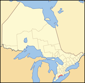 Location of Elgin County in Canada | |
| Coordinates: 42°45′N 81°10′W / 42.750°N 81.167°WCoordinates: 42°45′N 81°10′W / 42.750°N 81.167°W | |
| Country | |
| Province | |
| Organized | 1851 from Suffolk County |
| County seat | St. Thomas |
| Municipalities | List
|
| Area | |
| • Land | 1,845.41 km2 (712.52 sq mi) |
| Population (2016)[1] | |
| • Total | 50,069 |
| • Density | 27.1/km2 (70/sq mi) |
| Time zone | UTC-5 (EST) |
| • Summer (DST) | UTC-4 (EDT) |
| Area code(s) | 519 / 226 / 548 |
| Website | www.elgincounty.ca |

Elgin County is a county of the Canadian province of Ontario with a 2016 population of 50,069. Its population centres are St. Thomas, Aylmer, Port Stanley, Belmont, Dutton and West Lorne. The county seat is St. Thomas, which is separated from the county but within its geographic boundary.
Subdivisions[]
Elgin County is composed of seven incorporated municipalities (in order of population):
- Municipality of Central Elgin
- Township of Malahide
- Town of Aylmer
- Municipality of Bayham
- Municipality of West Elgin
- Township of Southwold
- Municipality of Dutton/Dunwich
The City of St. Thomas is geographically within the boundaries of Elgin County and part of the Elgin census division, but is separated from county administration.
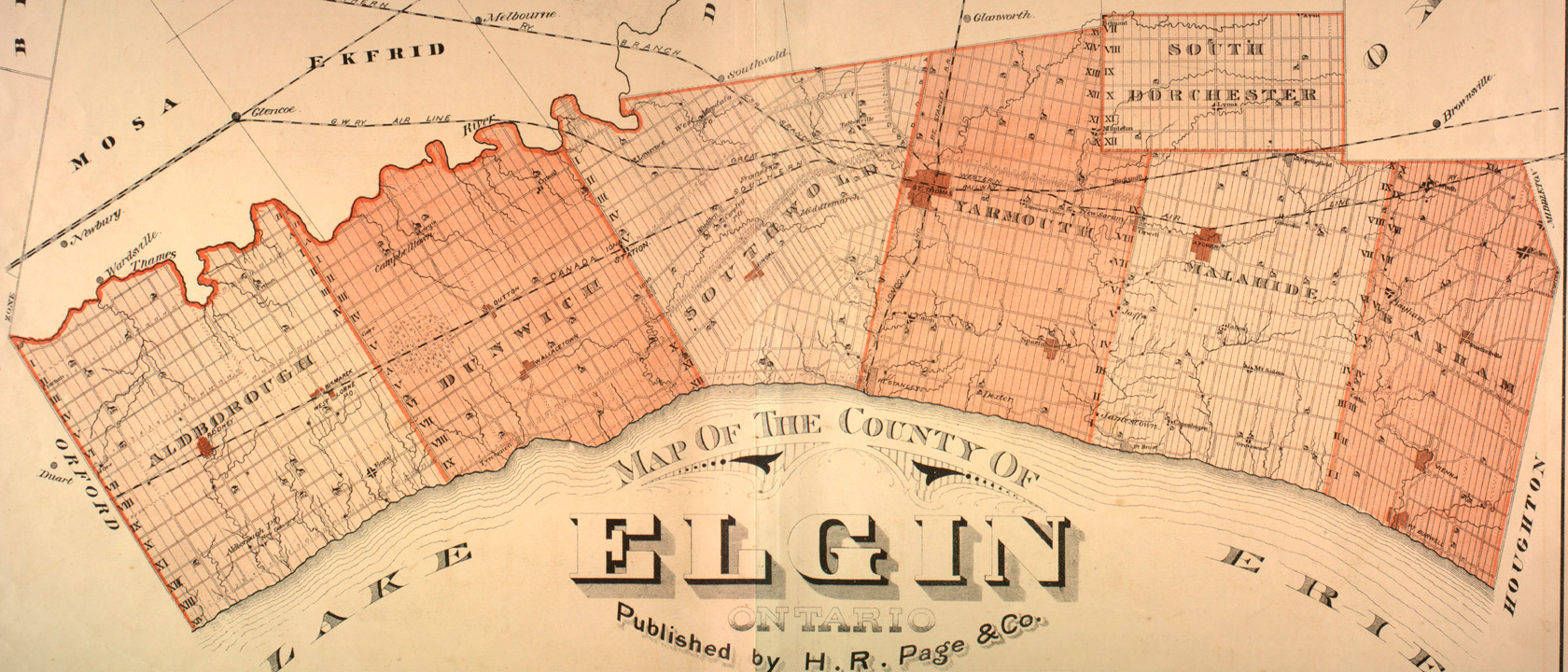
Historical townships[]

Originally Elgin County was once part of Middlesex County,[2] which was reorganized as the United Counties of Middlesex and Elgin in 1851.[3] Elgin was named after Lord Elgin, who was Governor-General of Canada at the time.
The County was separated from Middlesex in September 1853.[4]
| Township | Area | Description |
|---|---|---|
| Aldborough | 75,197 acres (117 sq mi; 304 km2) | In the early days it had a forest of oak, chestnut and black walnut. It was first settled in 1804. |
| Bayham | 56,350 acres (88 sq mi; 228 km2) | Organized in 1810. It was named for Bayham Abbey in Kent. |
| Dunwich | 69,592 acres (109 sq mi; 282 km2) | First settled in 1803. During the War of 1812 only twelve families lived in the township. In 1817 a company of Selkirk's Highlander settled in the Township The Township is named after Dunwich in Suffolk. |
| Malahide | 69,181 acres (108 sq mi; 280 km2) | Organized in 1810, named for Malahide Castle in Ireland, the former home of Thomas Talbot, patriot of the region. The Township was first settled in 1810. |
| South Dorchester | 30,560 acres (48 sq mi; 124 km2) | Although surveyed in 1798, it was not settled until 1826. |
| Southwold | 72,898 acres (114 sq mi; 295 km2) | Opened for settlement in 1797, however the first colonist arrived in 1809. Named for Southwold in Suffolk. |
| Yarmouth | 69,181 acres (108 sq mi; 280 km2) | Surveyed in 1792 and settled in 1810. |

Demographics[]
| Year | Pop. | ±% |
|---|---|---|
| 1996 | 47,752 | — |
| 2001 | 48,250 | +1.0% |
| 2006 | 49,241 | +2.1% |
| 2011 | 49,556 | +0.6% |
| 2016 | 50,069 | +1.0% |
| 2016[1], 2011[6], 2006[7], earlier[8] | ||
Elgin County had a population of 50,069 based on the 2016 Canada census, representing a 1.0% growth since the 2011 census, lower than the provincial average of 4.6%. Residents of Elgin County are slightly older and poorer than the Ontario average. Specifically, as of 2016, the median age of Elgin County is 42.5 years, older than the Ontario median of 41.3. The median household income was $66,494 which is lower than the provincial average of $74,287.[a]
Notable persons from Elgin County[]
- Horace Harvey - Chief Justice of Alberta
- John Kenneth Galbraith - Canadian/American economist
- Mitchell Hepburn - Premier of Ontario
- Rachel McAdams - Actress
- Joe Thornton - NHL - Professional Hockey Player
- Bo Horvat - NHL - Professional Hockey Player
See also[]
- List of municipalities in Ontario
- List of Ontario Census Divisions
- Talbot Trail
- Southern Ontario
- List of townships in Ontario
- List of secondary schools in Ontario#Elgin County
Notes[]
- ^ Excluding population, all figures are for the Elgin census division, which combines Elgin County and the City of St. Thomas.
References[]
- ^ a b c "2016 Community Profiles". 2016 Canadian Census. Statistics Canada. February 21, 2017.
- ^ An Act for abolishing the Territorial Division of Upper-Canada into Districts, and for providing temporary Unions of Counties for Judicial and other purposes, and for the future dissolutions of such Unions, as the increase of wealth and population may require, S.Prov.C. 1849, c. 78, Sch. C
- ^ An Act to make certain alterations in the Territorial Divisions of Upper Canada, S.Prov.C. 1851, c. 5, Sch. A, par. 35-36; Sch. B
- ^ "Proclamation". Canada Gazette. XII (29): 1452–1453.
- ^ Middleton, Jesse Edgar; Landon, Fred (1927). Province of Ontario: A History 1615 to 1927. Toronto: Dominion Publishing Company.
- ^ "2011 Community Profiles". 2011 Canadian Census. Statistics Canada. July 5, 2013.
- ^ "2006 Community Profiles". 2006 Canadian Census. Statistics Canada. March 30, 2011.
- ^ "2001 Community Profiles". 2001 Canadian Census. Statistics Canada. February 17, 2012.
External links[]
| Wikimedia Commons has media related to Elgin County, Ontario. |
- 1877 Historical Map of Elgin County
- Elgin Connects Portal
- County of Elgin website
- Municipality of Malahide
- Central Elgin
- West Elgin
- Town of Aylmer
Places adjacent to Elgin County | ||||||||||||||||
|---|---|---|---|---|---|---|---|---|---|---|---|---|---|---|---|---|
| ||||||||||||||||
| Counties | |
|---|---|
| Districts | |
| Regional municipalities | |
| Single-tier municipalities | |
| Separated municipalities | |
| Regions | |
| |
- Elgin County
- Counties in Ontario
- Lake Erie
- Southwestern Ontario