Great Blue Norther of November 11, 1911
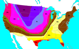 Low temperatures recorded at midnight EST (05:00 UTC) on November 12, 1911 | |
| Type | Extratropical cyclone Winter storm Cold wave Blizzard Tornado outbreak |
|---|---|
| Highest winds | |
| Tornadoes confirmed | 12+ |
| Max. rating1 | F4 tornado |
| Damage | Unknown[nb 1] |
| Areas affected | Central United States |
| 1Most severe tornado damage; see Fujita scale | |
On Saturday, November 11, 1911, a cold snap, known as the Great Blue Norther or 11/11/11, affected the Central United States. Many cities broke record highs, going into the 70s and 80s early that afternoon. By nightfall, cities were dealing with temperatures in the teens and single-digits on the Fahrenheit scale. This is the only day in many midwest cities' weather bureau jurisdictions where the record highs and lows were broken for the same day. Some cities experienced tornadoes on Saturday and a blizzard on Sunday.[2] A blizzard even occurred within one hour after an F4 tornado hit Rock County, Wisconsin.[3]
The front produced severe weather and tornadoes across the upper Mississippi Valley, a blizzard in Ohio, and the windy conditions upon front passage caused a dust storm in Oklahoma.[4] Alongside the dramatic temperature swings, the cold front brought a destructive tornado outbreak to parts of the Midwest. At least 12 tornadoes touched down across five states as the system moved through, resulting in 13 fatalities. Hundreds of structures were destroyed by the storms and many areas had to conduct search and rescue missions amidst blizzard conditions. According to Thomas P. Grazulis, this outbreak was one of the worst on record in November for the north-central States.[3]
Background[]
The main cause of such a dramatic cold snap was an extremely strong storm system separating warm, humid air from frigid, arctic air. Dramatic cold snaps tend to occur mostly in the month of November, though they can also come in February or March.[4] These arrivals of Continental Polar or Arctic air masses are generally called northers, and the one in question was marked by a mass of steel blue clouds in the vicinity of the surface front, hence the name. Although temperature drops of this extent have happened on other occasions, as recently as February 2009, the fact that the 1911 cold front passage was during the autumn and came after such warm weather contributed to the properties mentioned in this article.[5]
Impact[]
Temperatures in Kansas City had reached a record high of 76 °F (24 °C) by late morning before the front moved through. As the cold front approached, the winds increased turning from southeast to northwest. By midnight, the temperature had dropped to 11 °F (−12 °C), a 65 °F (18 °C) difference in 14 hours.[4] In Springfield, the temperature difference was even more extreme. Springfield was at 80 °F (27 °C) at about 3:45 p.m. CST (21:45 UTC), before the cold front moved through. Fifteen minutes later, the temperature was at 40 °F (4 °C) with winds out of the northwest at 40 mph (64 km/h). By 7:00 p.m. CST (01:00 UTC 12 November) the temperature had dropped a further 20 °F (−7 °C), and by midnight (06:00 UTC), a record low of 13 °F (−11 °C) was established. It was the first time since records had been kept for Springfield when the record high and record low were broken in the same day. The freak temperature difference was also a record breaker: 67 °F (19 °C) in 10 hours.[4] Record highs and lows were established on the same day in Oklahoma City as well with a high of 83 °F (28 °C) and low of 17 °F (−8 °C); temperature difference: 66 °F (19 °C). Both records still hold.[5][6] In Chicago, Illinois, people died separately of heatstroke and cold, respectively, within 24 hours, the first such incidence on record in the city.[7]
See also[]
- List of tornadoes and tornado outbreaks
- Tuesday
Notes[]
References[]
- ^ Walz, Ferdinand J. (November 1911). Walz, Ferdinand J. (ed.). "District No. 3, Ohio Valley". Monthly Weather Review. Climatological Data. Boston: American Meteorological Society. 39 (11): 1659. Bibcode:1911MWRv...39.1658W. doi:10.1175/1520-0493(1911)39<1658:DNOV>2.0.CO;2. Retrieved 26 April 2021.

- ^ "Waterloo Swept By Cyclone; Cutting Swath Through the Business Section of Town". Fort Wayne Journal Gazette. November 12, 1911. Archived from the original on September 30, 2011. Retrieved November 11, 2011.
- ^ a b Grazulis, Thomas P. (November 1990). Significant Tornadoes 1880–1989. Vol. 2. St. Johnsbury, Vermont: The Tornado Project of Environmental Films. p. 125. ISBN 1-879362-02-3.
- ^ a b c d Albert, Drew (October 2003). "The Great "Blue Norther" of November 11, 1911". Ozarks Weather Observer. Springfield, Missouri: National Weather Service. Archived from the original on 13 November 2011. Retrieved November 11, 2011.
- ^ a b Branick, Mike (Winter 2003–2004). "The Record Events of November 11, 1911" (PDF). The Southern Plains Cyclone. Norman, Oklahoma: National Weather Service. pp. 1–2. Archived from the original (PDF) on 5 November 2011. Retrieved 26 April 2021.
- ^ Lee, Jim (11 November 2011). "100 years ago…the "Great Blue Norther" of 11/11/1911". La Crosse, WI Weather Forecast Office. Des Moines, Iowa: National Weather Service. Retrieved 26 April 2021.
- ^ Cox, Henry J. (November 1911). Cox, Henry J. (ed.). "District No. 4, the Lake Region". Monthly Weather Review. Climatological Data. Boston: American Meteorological Society. 39 (11): 1671. Bibcode:1911MWRv...39.1670C. doi:10.1175/1520-0493(1911)39<1670:DNTLR>2.0.CO;2. Retrieved 26 April 2021.
- Cold waves in the United States
- 1911 natural disasters in the United States
- 1911 meteorology
- November 1911 events