Guadalajara, Spain
show This article may be expanded with text translated from the corresponding article in Spanish. (October 2012) Click [show] for important translation instructions. |
Guadalajara | |
|---|---|
 | |
 Flag  Coat of arms | |
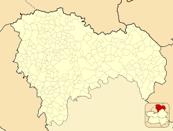
 Guadalajara Location in the Province of Guadalajara, Castilla–La Mancha and Spain | |
| Coordinates: 40°38′1.36″N 3°10′2.62″W / 40.6337111°N 3.1673944°WCoordinates: 40°38′1.36″N 3°10′2.62″W / 40.6337111°N 3.1673944°W | |
| Country | Spain |
| Region | Castilla–La Mancha |
| Province | Guadalajara |
| Founded | 8th century; possible prior Iberian origin |
| Government | |
| • Mayor | Alberto Rojo Blas (PSOE) |
| Area | |
| • Municipality | 235.49 km2 (90.92 sq mi) |
| Elevation | 708 m (2,323 ft) |
| Highest elevation | 972 m (3,189 ft) |
| Lowest elevation | 620 m (2,030 ft) |
| Population (2019) | |
| • Municipality | 85,871 |
| • Density | 360/km2 (940/sq mi) |
| • Urban | 161,683 |
| Demonyms | Guadalajareño/a[a] |
| Time zone | UTC+1 (CET) |
| • Summer (DST) | UTC+2 (CEST) |
| Postal code | 19001–5 |
| Dialing code | 949 |
| Website | Official website |


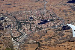
Guadalajara (/ˌɡwɑːdələˈhɑːrə/, Spanish: [ɡwaðalaˈxaɾa] (![]() listen))[2] is a city and municipality in Spain, located in the autonomous community of Castilla–La Mancha. It is the capital of the Province of Guadalajara.
listen))[2] is a city and municipality in Spain, located in the autonomous community of Castilla–La Mancha. It is the capital of the Province of Guadalajara.
Lying on the central part of the Iberian Peninsula at roughly 685 meters (2,247 ft) metres above sea level, the city straddles the Henares River. As of 2018 it has a population of 86,222 which makes it the region's second most populated municipality.
History[]
Alleged identification with Arriaca[]
A Roman town called Arriaca, possibly founded by a pre-Roman culture, is known to have been located in that region. There is however no archeological proof of its existence, only references in texts such as the Ruta Antonina, which describe it as being in the hands of the Carpetani[3] when encountered by the Romans. The city, as Caracca,[4] was incorporated into the Roman province of Hispania Tarraconensis. The city was on the high road from Emerita (modern Mérida) to Caesaraugusta (modern Zaragoza), 22 M. P. northeast of Complutum (modern Alcalá de Henares).
Early Middle Ages[]
The town of Guadalajara was founded in the 8th century,[citation needed] in the time of the Emirate of Córdoba. It was officially known as Madinat-al-Faray in the 9th and 10th centuries.[5] The town was later known as Wādī l-Ḥiŷāra (Arabic: وادي الحجارة), possibly meaning "Valley of Stones" (as in river gravel);[6] in theory it may be a literal translation of the Iberian name Arriaca.[6] It has also been also proposed that Ḥajāra should not be understood as stones/gravel, but in the sense of "castles" or "fortified rocks".[6]
Part of the Middle March of Al-Andalus, the city and its wider district was controlled by the Masmuda berber clan of the Banū Sālim who governed on behalf of the Umayyad rulers of Córdoba.[6] During the Muslim period an Alcázar (fortress) was built by the mid-9th century,[7] as well as the Bridge over the Henares (its construction has been tentatively dated by the late 10th century or early 11th century).[8] City walls protecting the city were also built then.[9]

Guadalajara was part of the territory annexed by Alfonso VI of León-Castile in the 1085 conquest of the Taifa of Toledo, with the city of Guadalajara surrendering and offering no resistance.[10] Tradition claims however that a contingent led by Álvar Fáñez de Minaya (one of the lieutenants of El Cid) seized the city on 24 June, at night.[10]
The area was repopulated with people from the North (Castilians from the mountains and Merindades, Basques and Navarreses mainly).[citation needed]
Alfonso VII granted Guadalajara its first fuero on 3 May 1133.[11] This charter progressively incorporated several amendments.[12] The second fuero, probably conceived during the reign of Alfonso VIII, was anyway confirmed by Ferdinand III on 26 May 1219 and 13 April 1251.[13]
For most of its history, up until the 20th century, Guadalajara's water supply came from two sources: the Henares river and the springs located along the cornice formed by the border of the limestone moors of La Alcarria.[14] Control over the scarce water resources was fought over and it became a symbol of social status for the local nobility during the Late Middle Ages.[15]
During the reign of Alfonso X of Castile, the protection of the king allowed the city to develop its economy by protecting merchants and allowing markets.
Rule of the Mendozas[]

Traditionally a town, with a vote in the Cortes of Castile, the town became under the influence of the powerful Mendoza family until well into the Early Modern period.[16] Despite the former meddling that underpinned the political control of the city, Guadalajara was not enshrined as formal seigneurial jurisdiction of the Mendozas in a legal sense.[16] The family included Íñigo López de Mendoza, also known as Marqués de Santillana (1398–1458), and Pedro González de Mendoza (1428–1495), Great Cardinal of Spain and adviser of the Catholic Monarchs.
The Mendoza family held the title of Dukes and Duchesses of from 1475. On 25 March 1460, Henry IV granted Guadalajara the status of 'City'.[17] In this period, the Mendoza Family ordered the building of El Palacio del Infantado as their main residence. It was completed in the early 1480s and it is considered by many the oldest surviving building built in a pure Renaissance style outside Italy.
The city's economy prospered thanks to the development of an specialised artisanate and a bustling trade.[18]
In the early 16th century, the city was one of the main focal points of the iluminismo (or alumbrados) in the Kingdom of Toledo,[19] linked to heterodox religious figures such as and .
In the context of the Revolt of the Comuneros across the Crown of Castile, the comunero rebels in Guadalajara, as early as 5 June 1520, asked the Duke of the Infantado, Diego Hurtado de Mendoza, to join the anti-imperial revolt.[20] The demonstrators lit the houses of the procurators who went to the Cortes of La Coruña to vote in favour of the taxes and obligations levied by Emperor Charles V.[20] The Duke of Infantado played a cautious waiting game to see which side would win, finally choosing to endorse the Emperor in 1521. He ordered the beheading of the local leaders of the insurgency and the deportation of his own son and successor Íñigo López de Mendoza, who had leaned towards the comunero cause.[20]
By 1591, the city had a population of 6,754.[21]

Crisis[]
The Crisis of the 17th century took a heavy toll in many Castilian cities, and particularly in Guadalajara.[18] The city was affected by the 1610 expulsion of the moriscos both in terms of the net demographic loss (10% of the population) as well as by their critical weight in key sectors of the local economy such as the artisanate and trade.[18] Many palaces were left forsaken.[22] The Mendozas left the city for good in 1657.[22]
During the War of the Spanish Succession, in the early 18th century, Guadalajara was sacked. Ravaged by the Austracist army, a largely ruined Guadalajara hit then its lowest demographic point, with only around 2,200 inhabitants.[23] Without external assistance the city may have simply ceased to exist.[24] The 20,000,000 maravedies indebted to the Royal Treasury were forgiven in 1716.[24] Philip V ordered the establishment of the Real Fábrica de Paños (Royal Factory of Clothes), which was opened in the city in 1719 in the Palacio del Marqués de Montesclaros,[25] critically helping the city to move on from the calamitous situation it found itself.[24]
Contemporary times[]

The 19th century started with two major setbacks: the damages caused by the Peninsular War (1808–1814) and the closing of the Real Fábrica de Paños in 1822. In 1808, Guadalajara was taken by the French Army led by and the city was destroyed. During the war, the 14 convents in the city were abandoned and turned into barracks, paving the way for the future processes of desamortización, most decisively in between 1833 and 1843.[26]
The desamortización entailed the change of use of religious buildings (turned to hospitals, high schools, military workshops),[27] the demolition of some convents to widen street space and to erect new residential areas,[28] and the reduction of the share of church properties in the estate structure.[29]
Both the declaration of Guadalajara as provincial capital and the parallel installment of the Academy of Military Engineers in the city in 1833, fostered some slow growth.[30]
Railway transport arrived to the city with the opening of the Madrid–Guadalajara stretch of the Madrid–Zaragoza line (built by the , MZA) on 3 May 1859.[31] Conversely, the Guadalajara–Jadraque stretch to the northeast was opened on 5 October 1860.[31]
The municipality had a population of 12,662 in 1900, the most populated municipality in the province, followed by Sigüenza (10,581).[32] The 20th century saw the construction of the current water supply system bringing the waters of the Sorbe to the city.[14]
On 21 July 1936, following the general coup d'état of 18 July that sparked the Spanish Civil War (1936–1939), the conspiring officers in the city (joined by the forces of public order and some civilians, amounting to an overall force of roughly 800) raised in arms, seizing control of the city.[33] The next day, the Republican Government in Madrid sent Ildefonso Puigdendolas to quell the rebellion and secure the city.[33] The rebels were pushed in retreat to the Cuartel de Aerostación, where they surrendered.[33] The militias executed roughly one hundred of them.[33]
The city was the target of several aerial bombing attacks by the Francoist faction throughout the conflict;[34] the most known one, in December 1936, affected the Palacio del Infantado.[34]

On 8 March 1937, the four divisions of the Italian Corpo Truppe Volontarie (CTV), attacked Republican positions 16 kilometres (10 mi) outside Guadalajara as a supporting diversionary attack supporting the Nationalist Jarama Offensive launched at the beginning of February. After four days of slow, cautious advance during rainy weather, the tanks started attacking down substantial hard paved roads and outran their air and anti-aircraft artillery support. Shortly thereafter, Republican aviation assets airborne in newly cleared skies found the tanks and infantry in a traffic jam on the main road heading into Guadalajara.[35] The Republican aircraft proceeded to attack and destroy all the vehicles in the mechanized spearhead. The CTV was thrown back with casualties in the thousands. Ernest Hemingway and other war correspondents labeled the attack, "Italian débâcle at Guadalajara." Republican forces enjoyed an increase in recruitment as a result of the victory.
This defeat at Guadalajara had two long-standing effects. First, the Italian Army of the Mussolini dictatorship acquired a reputation for incompetence that never left it before the armistice of 1943. Second, some observing nations adopted an armored doctrine that ruled out tanks operating as an independent force, but emphasized tying them tightly to large infantry formations.[36]
The Civil War and the heavy fighting around the city caused significant damage. After two decades of slow rebuilding, Guadalajara was included in 1959 in the development plans addressing the congestion of Madrid's industrial estates (El Plan de Descongestión Industrial de Madrid en Castilla-La Mancha). These plans attempted to move industrial and accompanying residential growth to the periphery, resulting in increased industry presence in Guadalajara. Since then, Guadalajara has been one of the cities in Spain with greatest relative growth.
Guadalajara absorbed the municipalities of Taracena, and Iriépal in 1969, Marchamalo in 1972 and in 1973.[37][38] Later, in 1999, Marchamalo segregated from Guadalajara, becoming a standalone municipality again.[39]
Nowadays, Guadalajara is involved in urban development plans that are quickly increasing the population of the city. New districts like Aguas Vivas (Live Waters) have[when?] been inaugurated.[citation needed]
Ciudad Valdeluz was planned to increase the number of inhabitants of Guadalajara by 30,000, creating a new city around the AVE Station (Spanish High-Speed Trains). The company investing in the construction of Ciudad Valdeluz went bankrupt. Fewer than 500 inhabitants decided to occupy their flats and the remaining infrastructure is slow degrading. The AVE trains are used by only 60 passengers a day.[40]
The town-plannings have dramatically increased the cost of the new houses, and it has become one of the cheapest provinces in Spain for house-buying to be the 3rd province in Spain with the most expensive square meter.[citation needed]
Geography[]
Location[]

Guadalajara is located the central part of the Iberian Peninsula, in the southern half of the Inner Plateau.
Chosen as settlement on the basis of defensive purposes, the historic urban core of the city lies on a small elevation near the left-bank of the Henares River, also enclosed to the East and West by two small ditches corresponding to two watercourses, and San Antonio, respectively, forming a narrow and easily defendable space upon their confluence with the Henares.[41]
The municipality spans across a total area of 235.49 km2.[42]
Climate[]
Guadalajara enjoys a Mediterranean climate (Köppen climate classification: Csa) with continental influences for being well inland at 700 meters above sea level. Summers are hot with relatively cool nights, while winters are cool with cold nights. The lowest temperature ever recorded in Guadalajara is −12.5 °C (9.5 °F) on 12 January 2009. The highest temperature ever recorded is 43.5 °C (110.3 °F) on 10 August 2012.[43]
| hideClimate data for Guadalajara, El Serranillo, 639 m (1985–2010) 40°39′33″N 3°10′24″W / 40.65917°N 3.17333°W | |||||||||||||
|---|---|---|---|---|---|---|---|---|---|---|---|---|---|
| Month | Jan | Feb | Mar | Apr | May | Jun | Jul | Aug | Sep | Oct | Nov | Dec | Year |
| Average high °C (°F) | 10.7 (51.3) |
13.0 (55.4) |
17.0 (62.6) |
18.4 (65.1) |
23.5 (74.3) |
29.9 (85.8) |
33.5 (92.3) |
32.4 (90.3) |
27.4 (81.3) |
20.9 (69.6) |
14.7 (58.5) |
11.0 (51.8) |
21.0 (69.8) |
| Daily mean °C (°F) | 4.9 (40.8) |
6.3 (43.3) |
9.5 (49.1) |
11.1 (52.0) |
15.5 (59.9) |
20.8 (69.4) |
23.7 (74.7) |
23.0 (73.4) |
18.7 (65.7) |
13.9 (57.0) |
8.3 (46.9) |
5.5 (41.9) |
13.4 (56.1) |
| Average low °C (°F) | −1 (30) |
−0.4 (31.3) |
1.9 (35.4) |
3.8 (38.8) |
7.5 (45.5) |
11.7 (53.1) |
13.7 (56.7) |
13.6 (56.5) |
10.0 (50.0) |
6.8 (44.2) |
1.9 (35.4) |
−0.1 (31.8) |
5.8 (42.4) |
| Average precipitation mm (inches) | 35 (1.4) |
32 (1.3) |
25 (1.0) |
50 (2.0) |
53 (2.1) |
25 (1.0) |
12 (0.5) |
16 (0.6) |
28 (1.1) |
68 (2.7) |
42 (1.7) |
46 (1.8) |
432 (17.2) |
| Average rainy days | 6.1 | 5.9 | 4.7 | 8.0 | 7.3 | 3.8 | 1.8 | 2.1 | 4.0 | 8.1 | 5.7 | 6.3 | 63.8 |
| Average snowy days | 0.9 | 1.1 | 0.3 | 0.2 | 0.0 | 0.0 | 0.0 | 0.0 | 0.0 | 0.0 | 0.1 | 0.7 | 3.3 |
| Source: Agencia Estatal de Meteorología[44] | |||||||||||||
Politics and administration[]

Guadalajara is a municipality, the basic level of local division in Spain. The Ayuntamiento is the body charged with the municipal government and administration. The Plenary of the ayuntamiento is formed by 25 elected municipal councillors,[45] who in turn invest the mayor. The last municipal election took place on 26 May 2019. Since June 2019, the current mayor is Alberto Rojo Blas (Spanish Socialist Workers' Party).[46]
Demographics[]
Urban area[]
The 2020 report on urban areas in Spain published by the Ministry of Transports, Mobility and Urban Agenda identifies an urban area formed by the municipality of Guadalajara together with the neighbouring municipalities of Azuqueca de Henares, Alovera, Cabanillas del Campo, Marchamalo, Villanueva de la Torre and Chiloeches, with a population of 161,683 (2019).[47]
Architecture[]
- City proper
The bridge across the Henares river is Arab but built on Roman foundations. It has several historic buildings such as the Palacio del Infantado, as well as many churches, such as the church of San Ginés. Although Guadalajara is the biggest city in its diocese, the cathedral is located in the nearby town of Sigüenza. However, in Guadalajara, there is a "co-cathedral", the church of Saint Mary, in Mudejar style. Very close to this church, is placed the chapel known as "Capilla de Luis de Lucena", which has several fresco paintings on its walls and ceiling. The Church of los Remedios was declared Bien de Interés Cultural in 1924, and currently serves as the auditorium of the University of Alcalá. The Church of la Piedad was declared Bien de Interés Cultural in 1931.
Before the Civil War, Guadalajara was also known to be among the cities with most number of antique azulejos in the Iberian Peninsula housed in their buildings,[citation needed] since the city housed the largest collection of azulejos from Talavera de la Reina pottery;[citation needed] now almost all of those azulejos are lost.[citation needed]
- Pedanías

The small villages (pedanías) of Iriépal, Taracena, Usanos, and Valdenoches that belong to the municipality feature few monumental landmarks other than their humble rural churches. Thus, in Iriépal there is the Concepción church, constructed in the 16th century, which is known for its Mudéjar tower. In Taracena there is the 17th century Church of the Immaculate, in a very simple Renaissance style. In Usanos, there is the 13th-century Romanesque church of the Assumption, considerably remodeled in later periods and which features a crenelated tower.
Other types of monuments that are also noteworthy are the Iriépal laundry, work of 1910 in historicist style with funding from the Jose Santa María de Hita Foundation, and Iriépal (1858) and Valdenoches (1656) funds.
Throughout all the villages there are examples of Castilian mansions, quite modest compared to those in the cities. Of note also is Villaflores, a farming village built in 1887, designed by Ricardo Velázquez Bosco and commissioned to Maria Diega Desmaissières.
Transport[]
Guadalajara is served by two railway stations:
- Guadalajara railway station, located in the city centre and part of the classical railway lines, e.g., connecting Chamartín to Portbou/Cerbère.
- Guadalajara–Yebes railway station, located 5.6 kilometres (3.5 mi) at the South-East of Guadalajara, on the Madrid–Barcelona high-speed rail line.
Sports[]
The local men's football team, CD Guadalajara, currently play at the Tercera División, the fourth tier of the Spanish football system. Their home pitch is the Pedro Escartín. The BM Guadalajara play at the ASOBAL league, the top tier of the men's handball system in Spain. Their home fixtures are played at the Palacio Multiusos de Guadalajara. Guadalajara was one of the host cities of the 2013 World Men's Handball Championship.[48]
International relations[]
- Twin towns and sister cities
Guadalajara is twinned with:[49][50]
- Livorno, Italy (since 1979)
- Roanne, France (since 1980)
- Parma, Italy (since 1982)
- Guadalajara, Mexico (since 1982)
- Nitra, Slovakia (since 1988)
- Nuneaton, United Kingdom (since 1990)
- Guadalajara de Buga, Colombia (since 1996)
- Other city partnerships
Notable people[]
Distinguished people from or related to the town were:
- Álvar Fáñez de Minaya (fl. 1076–1114), alleged Christian conqueror of Guadalajara, represented on the city's coat of arms.
- Nuño Beltrán de Guzmán (c. 1490–1558), founder of Guadalajara, Mexico
- Isabel Muñoz-Caravaca (1838–1915), teacher, writer and labour activist.
- (1852–1889), pharmacist, linguist and botanist.
- (1852–1916), Countess of Vega del Pozo and Duchess of Sevillano.
- Jose de Creeft (1884–1982), famous sculptor born in Guadalajara.
- José Ortiz-Echagüe (1886–1980), military engineer and photographer, honorary lifetime president of SEAT and founder of CASA.
- Antonio Buero Vallejo (1916–2000), 20th-century writer.
See also[]
- Monument to Romanones (Guadalajara)
- Museum of Guadalajara
References[]
- Informational notes
- Citations
- ^ Cruz Herrera 2000–2001, p. 57.
- ^ "Guadalajara". Collins Dictionary. n.d. Retrieved 26 September 2014.
- ^ Antonine Itinerary pp. 436, 438.
- ^ Greek: Κάραιεκα, Ptol. ii. 6. § 57; Geog. Rav. iv. 44) or Caraca (Friedrich August Ukert, i. 2. p. 429.
- ^ Chavarría Vargas 2007, p. 96.
- ^ Jump up to: a b c d Chavarría Vargas 2007, p. 95.
- ^ Herrera Casado 1986, pp. 424–426.
- ^ Torres Balbás 1940, p. 232.
- ^ Herrera Casado 1986, p. 426.
- ^ Jump up to: a b Herrera Casado 1986, p. 420.
- ^ Chamocho Cantudo 2017, p. 78.
- ^ Chamocho Cantudo 2017, p. 79.
- ^ Chamocho Cantudo 2017, pp. 79–80.
- ^ Jump up to: a b Plaza de Agustín 2016, p. 253.
- ^ Plaza de Agustín 2016, p. 250.
- ^ Jump up to: a b Ortego Rico 2008, p. 280.
- ^ "Título de ciudad a favor de Guadalajara". Ayuntamiento de Guadalajara.
- ^ Jump up to: a b c Villaverde Sastre 1996, p. 12.
- ^ Santiago Otero 1955, p. 624.
- ^ Jump up to: a b c Serrano Belinchón, José (10 November 2019). "Los comuneros de Guadalajara". Nueva Alcarria.
- ^ Velasco Sánchez 2008, p. 183.
- ^ Jump up to: a b Villaverde Sastre 1996, p. 13.
- ^ Alegre Carvajal 1999, p. 235.
- ^ Jump up to: a b c Villaverde Sastre 1996, p. 21.
- ^ Alegre Carvajal 1999, pp. 235–236.
- ^ Redondo González & García Ballesteros 1983, p. 532.
- ^ Redondo González & García Ballesteros 1983, p. 533.
- ^ Redondo González & García Ballesteros 1983, p. 534.
- ^ Redondo González & García Ballesteros 1983, p. 535.
- ^ Redondo González & García Ballesteros 1983, pp. 525; 533.
- ^ Jump up to: a b Abascal Palazón, Juan Manuel (2015). "El despoblado de Santas Gracias (Espinosa de Henares, Guadalajara) y las obras del ferrocarril de 1859-1860" (PDF). Boletín de la Asociación de Amigos del Museo de Guadalajara (6): 10.
- ^ La población de Guadalajara (PDF). Población. Fundación BBVA. 2017. p. 5.
- ^ Jump up to: a b c d Schnell Quiertant 2007, p. 25.
- ^ Jump up to: a b Schnell Quiertant 2007, p. 35.
- ^ Airpower: Theory and Practice, John Gooch, Psychology Press, 1995, ISBN 0-7146-4657-1
- ^ Forging the Thunderbolt: History of the U.S. Army's Armored Force, 1917–45, Mildred Hanson Gillie/Jacob L. Devers, 1947, ISBN 0-8117-3343-2 Forging the Thunderbolt: History of the U.S. Army's Armored Force, 1917–45, Mildred Hanson Gillie/Jacob L. Devers, 1947, ISBN 0-8117-3343-2
- ^ Sánchez-Prieto Borja, Pedro (1995). "Introducción". Textos para la historia del español. Vol. II. Archivo Municipal de Guadalajara. p. 12. ISBN 84-8138-975-7.
- ^ "Variaciones de los municipios de España desde 1842" (PDF). Ministerio de Administraciones Públicas.
- ^ "El PSOE, único partido que ha gobernado Marchamalo desde su independencia". Guadalajara Diario. 22 January 2019.
- ^ Giles Tremlett (3 October 2011). "Spain's €44m Niemeyer centre is shut in galleries glut". The Guardian. Retrieved 4 October 2011.
- ^ Plaza de Agustín 2016, p. 252.
- ^ "Datos del Registro de Entidades Locales". Ministerio de Asuntos Económicos y Transformación Digital. Retrieved 16 May 2021.
- ^ "Valores extremos. Guadalajara, El Serranillo". Agencia Estatal de Meteorología (in Spanish). Gobierno de España. Retrieved 22 May 2019.
- ^ "Valores climatológicos normales: Guadalajara – Guadalajara, El Serranillo" (in Spanish). Agencia Estatal de Meteorología. Retrieved 7 June 2010.
- ^ "En Guadalajara, vence el PSOE de Alberto Rojo pero queda en el aire la Alcaldía a expensas de los pactos". 20minutos.es. 27 May 2019.
- ^ "El socialista Alberto Rojo, alcalde de Guadalajara con el apoyo de Cs". La Vanguardia. 15 June 2019.
- ^ "Áreas urbanas en España". Ministerio de Transportes, Movilidad y Agenda Urbana. 2020. p. 33.
- ^ "España en los mundiales de balonmano masculino". Cadena COPE. 7 January 2019.
- ^ "Ciudades hermanadas". Ayuntamiento de Guadalajara. Archived from the original on 27 February 2020. Retrieved 27 February 2020.
- ^ "Sister Cities, Public Relations". Guadalajara municipal government. Archived from the original on 2 March 2012. Retrieved 12 March 2013.
- ^ "Miasta partnerskie i zaprzyjaźnione Nowego Sącza". Urząd Miasta Nowego Sącza (in Polish). Archived from the original on 23 May 2013. Retrieved 1 August 2013.
- Bibliography
- Alegre Carvajal, Alicia (1999). Las villas ducales como tipología urbana. El ejemplo de la Villa Ducal de Pastrana (PDF). Universidad Nacional de Educación a Distancia.
- Chamocho Cantudo, Miguel Ángel (2017). Los fueros del reino de Toledo y Castilla La Nueva. Madrid: Agencia Estatal Boletín Oficial del Estado. ISBN 978-84-340-2407-6.
- Chavarría Vargas, Juan Antonio (2007). "Onomástica árabo-beréber en la toponimia de Castilla-La Mancha: Guadalajara". Anaquel de Estudios Árabes. Madrid: Universidad Complutense de Madrid. 18 (97): 93–116. ISSN 1130-3964.
- Cruz Herrera, María del Pilar (2000–2001). "Diccionario de gentilicios y seudogentilicios de la provincia de Guadalajara". Cuadernos de Etnología de Guadalajara. Guadalajara: Institución Provincial de Cultura "Marqués de Santillana". Diputación Provincial de Guadalajara (32–33): 9–110. ISSN 0213-7399.
- Herrera Casado, Antonio (1986). "La muralla de Guadalajara" (PDF). Wad-al-Hayara (13): 419–431.
- Ortego Rico, Pablo (2008). "El patrocinio religioso de los Mendoza: siglos XIV y XV". En la España Medieval. Madrid: Universidad Complutense de Madrid. 31: 275–308. ISSN 0214-3038.
- Plaza de Agustín, Javier (2016). "Agua y desarrollo urbano en la Castilla medieval: aportaciones a su estudio en la ciudad de Guadalajara". En la España Medieval. Ediciones Complutense. 39. doi:10.5209/rev_ELEM.2016.v39.52340. ISSN 0214-3038.
- Redondo González, Ángela; García Ballesteros, Aurora (1983). "El papel de la desamortización en la evolución de las ciudades españolas: los ejemplos de Guadalajara y Plasencia". Estudios Geográficos. Madrid: Consejo Superior de Investigaciones Científicas. 44 (172–173): 523–544. ISSN 0014-1496.
- Santiago Otero, Horacio (1955). "En torno a los alumbrados del Reino de Toledo". Salmanticensis. 2 (3): 614–654. ISSN 0036-3537.
- Schnell Quiertant, Pablo (2007). "La Guerra Civil Española en Guadalajara. Desarrollo bélico y restos materiales.". Catálogo Exposición "Guadalajara en Guerra". pp. 24–36.
- Torres Balbás, Leopoldo (1940). "El puente de Guadalajara" (PDF). Al-Andalus. V: 449–458. ISSN 0304-4335.
- Velasco Sánchez, Ángel Luis (2008). La población de Guadalajara, 1500–1650. Madrid: Universidad Autónoma de Madrid. ISBN 978-84-693-2807-1.
- Villaverde Sastre, María Dolores (1996). "Guadalajara hasta la guerra de sucesión" (PDF). Wad-al-Hayara (23): 11–22. ISSN 0214-7092. Archived from the original (PDF) on 18 December 2005.
External links[]
| Wikimedia Commons has media related to Guadalajara, Spain. |
 This article incorporates text from a publication now in the public domain: Smith, William, ed. (1854–1857). Dictionary of Greek and Roman Geography. London: John Murray. Missing or empty
 |title=(help)- Municipal Government
| show Municipalities in the province of Guadalajara |
|---|
| show Authority control |
|---|
- Guadalajara, Spain
- Municipalities in the Province of Guadalajara
- Roman sites in Spain