Gweal, Isles of Scilly
Gwydhyel | |
|---|---|
 Gweal viewed from Bryher | |
 Gweal | |
| Geography | |
| Coordinates | 49°57′12″N 6°22′12″W / 49.9533°N 6.3700°WCoordinates: 49°57′12″N 6°22′12″W / 49.9533°N 6.3700°W |
| OS grid reference | 25 |
| Archipelago | Isles of Scilly |
| Administration | |
United Kingdom | |
| Civil parish | Bryher |
| Demographics | |
| Population | 0 |

Gweal (Cornish: Gwydhyel "place of trees")[1] is one of the Isles of Scilly. It is the largest of the seven Norrard Rocks due west of Bryher. The name perhaps refers back to a time before most of the islands' area was inundated.
References[]
- ^ "Akademi Kernewek - Henwyn Tyller".
{{cite web}}: CS1 maint: url-status (link)
- Weatherhill, Craig Cornish Placenames and Language
- Ordnance Survey One-inch Map of Great Britain; Land's End, sheet 190. 1961
| Inhabited islands | 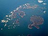 | |
|---|---|---|
| Uninhabited islands | ||
| Settlements |
| |
| Symbols | ||
| Topics |
| |
This article about a location in the Isles of Scilly, Cornwall is a stub. You can help Wikipedia by . |
Categories:
- Uninhabited islands of the Isles of Scilly
- Cornwall geography stubs