Hugh Town
Hugh Town
| |
|---|---|
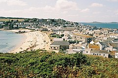 View from Buzza Hill, across the isthmus town, towards The Garrison | |
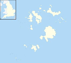 Hugh Town Location within Isles of Scilly | |
| Population | 1,097 |
| OS grid reference | SV903105 |
| Civil parish |
|
| Unitary authority | |
| Ceremonial county | |
| Region | |
| Country | England |
| Sovereign state | United Kingdom |
| Post town | ISLES OF SCILLY |
| Postcode district | TR21 |
| Dialling code | 01720 |
| Police | Devon and Cornwall |
| Fire | Isles of Scilly |
| Ambulance | South Western |
| UK Parliament | |

Hugh Town (Cornish: Treworenys[1] or Tre Huw) is the largest settlement on the Isles of Scilly and its administrative centre. The town is situated on the island of St Mary's,[2] the largest and most populous island in the archipelago, and is located on a narrow isthmus which joins the peninsula known as the Garrison (historically the Hugh) with the rest of the island.
The population recorded by the 2011 census was 1,097[3] (up from 1,068 in 2001). Unlike the rest of the Isles of Scilly, the freehold title to land in the town is not held by the Duchy of Cornwall — in 1949 it was sold to the inhabitants. The harbour however continues to be owned and run by the Duchy.[4]
Hugh Town becomes particularly busy during the May Day bank holiday weekend (the first weekend in May) when the World Pilot Gig Championships are held. The competing teams base themselves in the several bays of St Mary's Pool (the large natural bay to the north of Hugh Town) and the numerous races finish at the end of the harbour quay.
History[]
The name Hugh is derived from an Old English word 'hoh' meaning a promontory or elevated ground. The Garrison was originally known as The Hugh or Hugh Hill. The same word is used in Plymouth Hoe and Hoe Point on Gugh. Cemeteries containing native British people were found in 1949 and 1960 on the Porthcress side of the town, when housing was built. The remains are dated from the 1st to 4th century. A Roman altar was found on The Garrison in the 19th century and is now in Tresco Abbey Gardens. The area has not been excavated so there may be an undiscovered shrine or temple.[5] During medieval times Old Town was the main centre of population but from the 17th century onwards, due to its sheltered harbour, Hugh Town began to grow. Star Castle was built in 1593, the quay in 1601 and in the 18th century, as the military defences increased, The Hugh became known as The Garrison.[5]
Amenities and landmarks[]
Hugh Street is the main shopping area on the islands and business is quite reliant on tourism. There are several pubs, restaurants and hotels, as well as two banks and a post office. A notable building is the Star Castle, which overlooks the town from The Garrison and is now a hotel. Similarly, Tregarthen's Hotel is a Hugh Town landmark. It was originally the home of Captain Tregarthen who introduced the first sloop in 1849, 'Ariadne', that serviced the Hugh Town from Penzance.[6] Being on an isthmus, there are two beaches, the northern one (Town Beach) being along the bay which forms the island's main harbour; the southern beach and bay is named Porthcressa.

The Council of the Isles of Scilly is based at the Town Hall, located at The Parade, a small park situated at the centre of the isthmus (and originally a parade ground). The Duchy of Cornwall, which owns almost all the freehold land in the Isles of Scilly, as well as being the port authority, has its Isles of Scilly offices at Hugh House, located within the Garrison walls.[7]
The Church of England's St Mary's Church, the islands' Roman Catholic Church and St Mary's Methodist Church are all located on or near Church Street. The Isles of Scilly Museum is also located on Church Street.[8] The town has a public library and a police station. On the eastern outskirts of the town (heading towards Peninnis Head) are the NHS community hospital and local health centre, as well as other important public amenities such as the island's power station, the island's refuse depot and the town's fire station. The island's primary and secondary schools (both part of the federated Five Islands School) are situated to the southeast of the town, at Carn Gwaval, on the road to Old Town.
The island's airport is located approximately 1 mile (1.6 km) to the east of the centre of Hugh Town.
Climate[]
The Islands boast amongst the mildest and warmest climate in the UK. Often referred to as the sunshine isles, they benefit from more hours of sunshine than other regions - averaging 7.6 hours a day in July. As with most of the British Isles, Hugh Town experiences a maritime climate (Cfb) with mild summers and cool winters, however temperatures rarely dip below freezing.
| hideClimate data for Hugh Town St Mary's Heliport, elevation: 7m (1981-2010) | |||||||||||||
|---|---|---|---|---|---|---|---|---|---|---|---|---|---|
| Month | Jan | Feb | Mar | Apr | May | Jun | Jul | Aug | Sep | Oct | Nov | Dec | Year |
| Record high °C (°F) | 15.1 (59.2) |
15.0 (59.0) |
18.5 (65.3) |
20.8 (69.4) |
23.6 (74.5) |
26.1 (79.0) |
27.8 (82.0) |
26.8 (80.2) |
24.3 (75.7) |
19.9 (67.8) |
17.4 (63.3) |
15.3 (59.5) |
27.8 (82.0) |
| Average high °C (°F) | 9.7 (49.5) |
9.7 (49.5) |
10.8 (51.4) |
12.3 (54.1) |
14.5 (58.1) |
17.1 (62.8) |
19.2 (66.6) |
19.7 (67.5) |
18.0 (64.4) |
14.7 (58.5) |
12.1 (53.8) |
10.4 (50.7) |
14 (57) |
| Average low °C (°F) | 6.2 (43.2) |
6.0 (42.8) |
6.7 (44.1) |
7.2 (45.0) |
9.4 (48.9) |
11.9 (53.4) |
13.8 (56.8) |
14.1 (57.4) |
12.9 (55.2) |
10.6 (51.1) |
8.5 (47.3) |
6.9 (44.4) |
9.5 (49.1) |
| Record low °C (°F) | −7.2 (19.0) |
−4.3 (24.3) |
−1.6 (29.1) |
−0.4 (31.3) |
3.5 (38.3) |
6.8 (44.2) |
9.7 (49.5) |
8.6 (47.5) |
8.4 (47.1) |
5.5 (41.9) |
2.3 (36.1) |
−2.8 (27.0) |
−7.2 (19.0) |
| Average precipitation mm (inches) | 94.8 (3.73) |
69.7 (2.74) |
61.7 (2.43) |
54.6 (2.15) |
47.8 (1.88) |
47.8 (1.88) |
63.4 (2.50) |
67.2 (2.65) |
67.4 (2.65) |
96.6 (3.80) |
95.9 (3.78) |
98.2 (3.87) |
865.0 (34.06) |
| Mean monthly sunshine hours | 58.8 | 79.8 | 124.4 | 192.4 | 218.5 | 206.3 | 204.1 | 203.4 | 160.1 | 113 | 74.6 | 54.4 | 1,689.8 |
| Source: Met Office[9] | |||||||||||||
Harbour[]


The principal harbour of the Isles of Scilly (known as St Mary's Harbour) is located on the northern edge of the town, naturally formed by the bay at Town Beach (itself part of a larger bay named St Mary's Pool) and improved by the construction of a quay on its western side, which acts also as a breakwater. The quay is the terminal of the ferry to Penzance, currently the Scillonian III,[10] and the cargo vessel Gry Maritha; both vessels have St Mary's as their port of registry. The Duchy of Cornwall is the owner and the harbour authority (the St Mary’s Harbour and Pilotage Authority).[4]
The original quay was built in 1593 and an extension (or offshoot) began in 1836 to Rat Island under a contract of £4,000 to William Martin of Penzance. Martin resigned in November 1837 and Augustus Smith organised the completion. The enlargement of the harbour produced an increase in harbour dues as larger and deeper-draughted boats were now able to dock for loading, unloading, repairs or victualling. In 1889, Smith's successor Thomas Smith-Dorrien-Smith extended the pier a further 250 feet eastwards, at his own expense, so that the West Cornwall Steam Ship Company ships could dock. Despite Parliamentary opposition, a Pier and Harbour Provisional Order Bill passed in June 1890 gave him revenue from the harbour dues.[11]
The quay was extended by a further 23 metres (25 yards) in 2015, with new passenger and freight facilities being constructed too.[12] The extension to the quay allows for vessels of a greater draft (up to 3.9 metres; 12'9"). A small amount of land reclamation took place by Rat Island too, enlarging the space around the buildings there.[13][14]
Lifeboat station[]
On the eastern end of Town Beach (on the rocky outcrop known as Carn Thomas) is the St Mary's Lifeboat Station, first operated in 1837 and run by the RNLI.
Local geography[]
| show Neighbouring locations |
|---|
References[]
- ^ "Akademi Kernewek - Henwyn Tyller".
- ^ Ordnance Survey: Landranger map sheet 203 Land's End ISBN 978-0-319-23148-7
- ^ Combination of populations of the four output areas covering the settlement.
- ^ Jump up to: a b St Mary's Harbour official website
- ^ Jump up to: a b Sawyer, Katharine (June 2006). "Scilly Through the Ages – Hugh Town". Scilly now and then (4). p. 8.
- ^ Uren, J G (1907). Scilly and the Scillonians. UK. Rare Books Club. ISBN 978-1152596214
- ^ Duchy of Cornwall Isles of Scilly
- ^ Isles of Scilly Museum
- ^ "St Mary's Heliport". Met Office. Retrieved 27 December 2020.
- ^ "Archived copy". Archived from the original on 9 April 2007. Retrieved 6 April 2010.CS1 maint: archived copy as title (link) Cornwall Council website; Ferry Services page; retrieved April 2010
- ^ Vyvyan, Clara C (1960). The Scilly Isles. London: Robert Hale.
- ^ Kier our projects St Mary’s Harbour
- ^ Cornwall Council St Mary’s and Penzance Harbours Scheme Update August 2014
- ^ Scilly Today Update on the St Mary's Quay extension... (14 February 2015)
External links[]
![]() Media related to Hugh Town at Wikimedia Commons
Media related to Hugh Town at Wikimedia Commons
| show Authority control |
|---|
- Towns in the Isles of Scilly
- Ports and harbours of Cornwall
- Isthmuses of Europe
- Populated places on St Mary's, Isles of Scilly