Habikino
Habikino
羽曳野市 | |
|---|---|
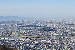 Panoramic view of downtown Habikino and Furuichi tomb group heritage site | |
 Flag  Emblem | |
 Location of Habikino in Osaka Prefecture | |
 Habikino Location in Japan | |
| Coordinates: 34°33′N 135°36′E / 34.550°N 135.600°ECoordinates: 34°33′N 135°36′E / 34.550°N 135.600°E | |
| Country | Japan |
| Region | Kansai |
| Prefecture | Osaka Prefecture |
| First official recorded | 150 AD |
| City settled | January 15, 1959 |
| Government | |
| • Mayor | Tsuguo Kitagawa |
| Area | |
| • Total | 26.44 km2 (10.21 sq mi) |
| Population (February 28, 2017) | |
| • Total | 113,256 |
| • Density | 4,300/km2 (11,000/sq mi) |
| Time zone | UTC+09:00 (JST) |
| City hall address | 4-1-1 Konda, Habikino-shi, Ōsaka-fu 583-8585 |
| Website | www |
| Symbols | |
| Flower | Peach |
| Tree | Mandarin Orange |

Habikino (羽曳野市, Habikino-shi) is a city located in Eastern Osaka Prefecture, Japan. It is particularly well known for its grape production, as well as the many ancient burial mounds that dot its landscape. The city was founded on January 15, 1959. As of February 28, 2017, the city has an estimated population of 113,256 and a population density of 4,300 persons per km².[1] The total area is 26.44 km².

Habikino city office
Sister cities and friendship cities[]
Within Japan[]
Internationally[]
Education[]
Universities and technical schools[]
- Shitennōji International Buddhist University
- Osaka Prefecture University Habikino Campus (formerly Osaka Prefecture College of Nursing)
All of Primary and Secondary schools are public.
Primary schools[]
- Eganosyo Primary school
- Komagatani Primary school
- Takawashi Primary school
- Takawashi Kita Primary school
- Takawashi Minami Primary school
- Tanbi Primary school
- Nishiura Primary school
- Nishiura Higashi Primary school
- Hanifu Minami Primary school
- Furuichi Primary school
- Furuichi minami Primary school
- Hakucho Primary school
- Habikigaoka Primary school
Secondary schools[]
- Kawarajou Secondary school
- Konda Secondary school
- Takawashi Secondary school
- Takawashi Minami Secondary school
- Minezuka Secondary school
Primary and Secondary school[]
- Habikino Hanifu Gakuen
Senior High schools[]
- Osaka Prefectural Kaifukan High School
Transportation[]
Rail[]
- Kintetsu Railway
- Minami Osaka Line: (to Osaka Abenobashi) - Eganoshō - Takawashi - (intervening stations in Fujiidera) - Furuichi - Komagatani - Kaminotaishi - (to Kintetsu Gose, Kashiharajingū-mae, Yoshino)
Bus[]
- Kintetsu Bus
- From Furuichi Station in the east, buses carry passengers on routes to Habikigaoka, Shitennōji International Buddhist University, Momoyama-dai, and Fujiidera Station.
- From Eganoshō Station in the west, there is a bus route to Kawachi-Matsubara Station which also covers Mihara-ku in Sakai.
- Kongō Bus
- Buses pick up passengers at Kaminotaishi Station.
Roads[]
National toll roads[]
Minami-Hanna Expressway (two interchanges within city limits):
- Habikino Interchange
- Habikino-Higashi Interchange
National non-toll roads[]
- National Route 166
- National Route 170 (Osaka Outer Loop Highway)
Prefectural roads[]
- Osaka/Nara Prefectural Route 12: Sakai-Yamato-Takada Highway
- Osaka Prefectural Route 27: Kashiwara-Komagatani-Chihayaakasaka Highway
- Osaka Prefectural Route 31: Sakai-Habikino Highway
- Osaka Prefectural Route 32: Mihara-Taishi Highway
Historical Place[]
Furuichi Kofungun, a group of Kofun, includes some kofun in Habikino.[2] They are recorded as World Heritage Sites.
Notable people[]
- Makate Asai, writer
- Yu Darvish, baseball player
- Sayuri Uenishi, politician
- Hiroki Uchi, idol singer, songwriter, actor and model
Surrounding municipalities[]
- Osaka Prefecture
- Mihara-ku, Sakai
- Matsubara
- Fujiidera
- Kashiwara
- Tondabayashi
- Taishi
- Nara Prefecture
References[]
- ^ "Official website of Habikino city" (in Japanese). Japan: Habikino City. Retrieved 10 April 2017.
- ^ "World Heritage Mozu-Furuichi Kofun Group: Mounded Tombs of Ancient Japan". www.mozu-furuichi.jp. Retrieved 2020-04-27.
External links[]
| Wikimedia Commons has media related to Habikino, Osaka. |
- Habikino City official website (in Japanese)
| show Authority control |
|---|
This Osaka Prefecture location article is a stub. You can help Wikipedia by . |
Categories:
- Cities in Osaka Prefecture
- Osaka geography stubs