Hackney Downs
| Hackney Downs | |
|---|---|
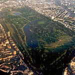
 Hackney Downs from the centre of the Downs looking northeast (October 2005) | |
 Hackney Downs Location within Greater London | |
| London borough |
|
| Ceremonial county | Greater London |
| Region |
|
| Country | England |
| Sovereign state | United Kingdom |
| Post town | LONDON |
| Dialling code | 020 |
| Police | Metropolitan |
| Fire | London |
| Ambulance | London |
| London Assembly | |

Hackney Downs is a park and an area of historically common land in the Lower Clapton area of the London Borough of Hackney. The name is sometimes also used to apply to the neighbourhood around the park.
Hackney Downs Park[]
The Downs open space was originally common land, preserved from the 1860s as parkland as a result of pressure by the Commons Preservation Society. At 16 hectares (40 acres),[1] the park is one of the larger open spaces wholly within the London Borough of Hackney. It has a play area, basketball courts, football pitches and a bowling green.
Occupying, as it does, a fairly central place in Hackney, the park used to be the yearly venue for the popular Hackney Show, but this event — which helped to give a sense of community and identity to an often-troubled borough — has been discontinued in recent times as a cost-cutting measure, as have the regular Fireworks Night shows. The park was given a Green Flag award in July 2008.[2]
Neighbourhood[]

The ‘Hackney Downs’ neighbourhood can be described as the western part of Lower Clapton; the area to the west of Cricketfield Road and east of the railway line. The streets north and south of the park are dominated by social housing (such as the Nightingale Estate) – these areas were largely rebuilt during the 1930s and 1960s.
Education[]
Hackney Downs School was also located here. The site has been redeveloped as the Mossbourne Community Academy.
Governance[]
Hackney Downs is currently a ward name, the represented area of three councillors, of Hackney Council up for election every 4 years.
| Party | Candidate | Votes | % | ±% | |
|---|---|---|---|---|---|
| Labour | Michael Desmond* | 2,076 | 20.7 | ||
| Labour | Anna-Joy Rickard* | 1,852 | 18.5 | ||
| Labour | Sem Moema | 1,687 | 16.8 | ||
| Green | Alastair Binnie-Lubbock | 1,597 | 15.9 | ||
| Green | Sheila Menon | 1,134 | 11.3 | ||
| Green | Sally Zlotowitz | 1,074 | 10.7 | ||
| Conservative | Mohammed Lunat | 229 | 2.2 | ||
| Conservative | Yasmin Lunat | 214 | 2.1 | ||
| Conservative | Agnieszka Rolkiewicz | 122 | 1.2 | ||
| Majority | |||||
| Turnout | 39.7 | ||||
| Labour hold | Swing | ||||
| Labour hold | Swing | ||||
| Labour hold | Swing | ||||
| Party | Candidate | Votes | % | ±% | |
|---|---|---|---|---|---|
| Green | Alexander Brown | 843 | 25.1% | ||
| Green | Stuart Coggins | 834 | 24.8% | ||
| Labour | Michael Desmond
|
2,115 | 62.9% | ||
| Conservative | Amy Gray | 214 | 6.4% | ||
| Conservative | Duncan Gray | 214 | 6.4% | ||
| Green | Andrew Guise | 719 | 21.4% | ||
| Liberal Democrats | Teena Lashmore | 342 | 10.2% | ||
| Conservative | Izabel Leosz | 149 | 4.4% | ||
| Liberal Democrats | Garry Malcolm | 249 | 7.4% | ||
| Labour | Rick Muir | 2,020 | 60.0% | ||
| Labour | Anna-Joy Rickard | 2,100 | 62.4% | ||
| Liberal Democrats | Mohammed Sadiq | 293 | 8.7% | ||
| Majority | 1,177 | 34.9% | |||
Transport and locale[]
| show Neighbouring areas of London. |
|---|

The two London Overground stations are Hackney Central on the North London line and Hackney Downs on the Lea Valley Lines to Liverpool Street.
References[]
- ^ Hackney Downs Common 30 June 2009 (Planning Inspectorate Casework) accessed 19 Sept 2009
- ^ Hackney Today 188 21 July 2008
External links[]
- Mossbourne Community Academy
- Blasts From The Past[permanent dead link] (LBH film of demolition of the tower blocks on the north side of the Downs).
| show London Borough of Hackney |
|---|
| Authority control: National libraries |
|---|
- Districts of the London Borough of Hackney
- Areas of London
- Parks and open spaces in the London Borough of Hackney
- Common land in London
- Clapton, London