Harrington, New South Wales
| Harrington New South Wales | |||||||||
|---|---|---|---|---|---|---|---|---|---|
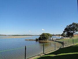 Manning River at Harrington | |||||||||
 Harrington | |||||||||
| Coordinates | 31°52′S 152°41′E / 31.867°S 152.683°ECoordinates: 31°52′S 152°41′E / 31.867°S 152.683°E | ||||||||
| Population | 3,033 (2016 census)[1] | ||||||||
| Postcode(s) | 2427 | ||||||||
| Elevation | 6 m (20 ft)[2] | ||||||||
| Location |
| ||||||||
| LGA(s) | Mid-Coast Council | ||||||||
| State electorate(s) | Port Macquarie | ||||||||
| Federal Division(s) | Lyne | ||||||||
| |||||||||

Harrington is a small village located on the northern entrance of the Manning River in New South Wales, Australia. It was established in 1853 and proclaimed a village on 26 September 1896. It is 15 km north-east of Taree[3] on the Mid North Coast, and 335 kilometres (208 mi) north east of the state capital, Sydney. At the 2011 census, Harrington had a population of 2,258.[4] It was named after the Earl of Harrington by the explorer, John Oxley.[3]
Schools[]
- Harrington Public School[5]
Emergency Services[]
- Marine Rescue Crowdy Harrington
- SES
- RFS
References[]
- ^ Australian Bureau of Statistics (27 June 2017). "Harrington (State Suburb)". 2016 Census QuickStats. Retrieved 4 February 2018.

- ^ Bureau of Meteorology. Retrieved on 2007-11-12.
- ^ Jump up to: a b "Harrington, New South Wales". Geographical Names Register (GNR) of NSW. Geographical Names Board of New South Wales. Retrieved 1 August 2013.
- ^ Australian Bureau of Statistics (31 October 2012). "Harrington (Urban Centre/Locality)". 2011 Census QuickStats. Retrieved 12 November 2007.
- ^ http://www.harrington-p.schools.nsw.edu.au/
External links[]
| Authority control |
|
|---|
This Mid-Coast Council geography article is a stub. You can help Wikipedia by . |
Categories:
- Towns in New South Wales
- Fishing communities in Australia
- Mid North Coast
- Suburbs of Mid-Coast Council
- Coastal towns in New South Wales
- Mid-Coast Council geography stubs