Tuncurry, New South Wales
| Tuncurry New South Wales | |||||||||||||||
|---|---|---|---|---|---|---|---|---|---|---|---|---|---|---|---|
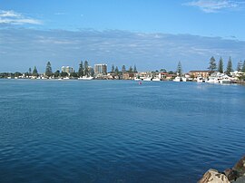
 View from Tuncurry's netted 'Rockpool' beach | |||||||||||||||
 Tuncurry | |||||||||||||||
| Coordinates | 32°10′30″S 152°29′56″E / 32.17500°S 152.49889°ECoordinates: 32°10′30″S 152°29′56″E / 32.17500°S 152.49889°E | ||||||||||||||
| Population | 6,186 (2016 census)[1] | ||||||||||||||
| Postcode(s) | 2428 | ||||||||||||||
| Elevation | 6 m (20 ft) | ||||||||||||||
| Time zone | AEST (UTC+10) | ||||||||||||||
| • Summer (DST) | AEDT (UTC+11) | ||||||||||||||
| Location | |||||||||||||||
| LGA(s) | Mid-Coast Council | ||||||||||||||
| Region | Mid North Coast | ||||||||||||||
| State electorate(s) | Myall Lakes | ||||||||||||||
| Federal Division(s) | Lyne | ||||||||||||||
| |||||||||||||||
Tuncurry is a coastal town in the Mid North Coast region of New South Wales, Australia, in the Mid-Coast Council LGA, about 308 km (191 mi) north north east of Sydney. It is immediately adjacent to its twin town of Forster, which is the larger of the two towns.
At the 2016 census, the Forster-Tuncurry area had a population of 19,918 people.[2] This number grows considerably in the tourist season. The population of Tuncurry alone was 6,186.[1]
History[]
In 1875, John Wright was the first white settler in Tuncurry.[3][4] The first land grant in this area was in 1875. The settlement was originally called North Shore and then North Forster and was renamed Tuncurry meaning "plenty of fish" in 1891 and then proclaimed a village in 1893.[5]
The area was well known in the early days for its timber cutting and sawmills. Timber was collected from the lakes and rivers by the logpunts (droghers).
A bridge over the Coolongolook River that marks the entrance to Wallis Lake was built in 1959 linking Forster and Tuncurry and replacing the punt service that had operated since 1890.
Tourism[]
Because of its close driving proximity to Sydney, Forster-Tuncurry has established itself as a popular summer holiday destination, where in the hotter months, the population swells considerably. The school holidays in the colder months also bring large numbers of holidaymakers.
Tuncurry's Nine Mile Beach is a popular swimming, surfing and fishing spot. Tuncurry Rockpool is a shark netted swimming enclosure, formed by breakwalls which mark the entrance to Wallis Lake. Tuncurry's lakefront areas are characterised by wharves and jetties which provide mooring for fishing boats and pleasure craft.
See also[]
Gallery[]

Pelican gather at the public boat ramp in Tuncurry

Fishing vessels moored at Tuncurry

View of bridge connecting Forster to Tuncurry.
References[]
- ^ Jump up to: a b Australian Bureau of Statistics (27 June 2017). "Tuncurry (State Suburb)". 2016 Census QuickStats. Retrieved 15 February 2018.

- ^ Australian Bureau of Statistics (27 June 2017). "Forster - Tuncurry (Urban Centre/Locality)". 2016 Census QuickStats. Retrieved 21 March 2013.

- ^ Great Lakes Historical and Maritime Museum. "TUNCURRY'S WORKING WATERFRONT – Wright's mill and shipyard". Retrieved 15 March 2018.
- ^ North Coast Run: Men and Ships of the New South Wales North Coast M. Richards P94 - 95 ISBN 978-0908031108
- ^ "Heritage & Culture". Great Lakes Tourism. Retrieved 3 May 2009.
External links[]
| Wikimedia Commons has media related to Tuncurry, New South Wales. |
- Towns in New South Wales
- Towns in the Hunter Region
- Suburbs of Mid-Coast Council
- Coastal towns in New South Wales


