Hartness State Airport
Coordinates: 43°20′37″N 072°31′02″W / 43.34361°N 72.51722°W

Hartness State Airport | |||||||||||||||
|---|---|---|---|---|---|---|---|---|---|---|---|---|---|---|---|
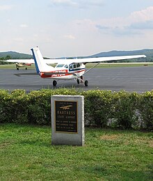 Hartness State Airport Tarmac, July 2008 | |||||||||||||||
| Summary | |||||||||||||||
| Airport type | Public | ||||||||||||||
| Owner | State of Vermont | ||||||||||||||
| Serves | Springfield, Vermont | ||||||||||||||
| Elevation AMSL | 577 ft / 176 m | ||||||||||||||
| Map | |||||||||||||||
 VSF Location of airport in Vermont / United States | |||||||||||||||
| Runways | |||||||||||||||
| |||||||||||||||
| Statistics (1998) | |||||||||||||||
| |||||||||||||||

Hartness State Airport (IATA: VSF, ICAO: KVSF, FAA LID: VSF) is a public airport located three miles (5 km) northwest of the central business district of Springfield, a town in Windsor County, Vermont, United States. It is owned by the State of Vermont.[1]
History[]
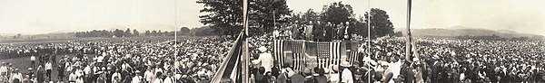
The airport was established by its namesake, James Hartness, who donated the land as the first airfield in Vermont.[2] After his trans-Atlantic flight, Charles Lindbergh toured the United States in the Spirit of St. Louis to promote aviation. He landed in Springfield on July 26, 1927 in his visit to Vermont and spoke at a large gathering at the airport.[3]
Facilities and aircraft[]
Hartness State Airport covers an area of 185 acres (75 ha) which contains two asphalt paved runways: 5/23 measuring 5,498 x 100 ft (1,676 x 30 m) and 11/29 measuring 3,000 x 75 ft (914 x 23 m).[1]
For the 12-month period ending November 20, 2012, the airport had 6,600 aircraft operations, an average of 127 per week: 95% general aviation, 3% air taxi and 2% military. There are 37 aircraft based at this airport: 76% single engine, 22% gliders and 3% multi-engine.[1]
References[]
- ^ Jump up to: a b c d FAA Airport Form 5010 for VSF PDF, effective 2007-07-05
- ^ Editors (February 17, 2017). "Vermont Aero Club". New England Aviation History. Retrieved 2020-06-22.CS1 maint: extra text: authors list (link)
- ^ Wicks, Frank (November 1999), Renaissance tool man, The American Society of Mechanical Engineers, archived from the original on March 2, 2008
External links[]
- Hartness State Airport at Vermont Airport Directory
- Resources for this airport:
- FAA airport information for VSF
- AirNav airport information for KVSF
- ASN accident history for VSF
- FlightAware airport information and live flight tracker
- NOAA/NWS weather observations: current, past three days
- SkyVector aeronautical chart, Terminal Procedures
| hide Authority control | |
|---|---|
| General | |
| National libraries | |
This article about an airport in Vermont is a stub. You can help Wikipedia by . |
- Airports in Vermont
- Buildings and structures in Springfield, Vermont
- Transportation buildings and structures in Windsor County, Vermont
- Northeastern United States airport stubs
- Vermont building and structure stubs
- Vermont transportation stubs