Herent
Herent | |
|---|---|
 | |
 Flag  Coat of arms | |
 Herent Location in Belgium
show Location of Herent in Flemish Brabant | |
| Coordinates: 50°54′N 04°40′E / 50.900°N 4.667°ECoordinates: 50°54′N 04°40′E / ���50.900°N 4.667°E | |
| Country | Belgium |
| Community | Flemish Community |
| Region | Flemish Region |
| Province | Flemish Brabant |
| Arrondissement | Leuven |
| Government | |
| • Mayor | Astrid Pollers |
| • Governing party/ies | N-VA, CD&V, Open vld |
| Area | |
| • Total | 32.73 km2 (12.64 sq mi) |
| Population (2018-01-01)[1] | |
| • Total | 21,632 |
| • Density | 660/km2 (1,700/sq mi) |
| Postal codes | 3020 |
| Area codes | 016, 02 |
| Website | www.herent.be |

Herent (Dutch pronunciation: [ˈɦeːrənt]) is a municipality located in the Belgian province of Flemish Brabant. The municipality comprises the villages and former municipalities of Herent proper, and . On January 1, 2016, Herent had a total population of 21,213. The total area is 32.73 km² resulting in a population density of 648 inhabitants per km². The current mayor (as of 2018) is .
Schools [2][]
- Catholic schools: De Kraal & Pastoor De Clerckschool
- Official Schools: De Bijenkorf (Flemish Community) & Toverveld (municipal)
Image gallery[]

Church in the centre of Herent
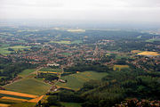
Aerial view of Veltem-Beisem


References[]
- ^ "Wettelijke Bevolking per gemeente op 1 januari 2018". Statbel. Retrieved 9 March 2019.
- ^ https://www.herent.be/product/364/scholen-in-herent
External links[]
 Media related to Herent at Wikimedia Commons
- Official website - Available only in Dutch
| show Places adjacent to Herent |
|---|

| Authority control |
|
|---|
This Flemish Brabant location article is a stub. You can help Wikipedia by . |
Categories:
- Municipalities of Flemish Brabant
- Flemish Brabant geography stubs