High Street, Glasgow
 Victorian tenements located at the northern end of the street. A mural depicting a "modern-day St. Mungo"[1] can be seen. | |||
| Part of | A8 | ||
|---|---|---|---|
| Maintained by |
Glasgow City Council Transport Scotland | ||
| Length | 700 m (2,300 ft) | ||
| Location | Glasgow | ||
| Postal code | G1 | ||
High Street is the oldest, and one of the most historically significant, streets in Glasgow, Scotland. Originally the city's main street in medieval times, it formed a direct north–south artery between the Cathedral of St. Mungo (later Glasgow Cathedral) in the north, to Glasgow Cross and the banks of the River Clyde. The High Street now stops at Glasgow Cross, with the southern continuation being the Saltmarket.[2]
History[]
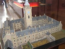
In 1246 the Dominican Order established a monastery on the east side of the street, hence the existence of Blackfriars' Street.[3] From 1460 to 1870, the original buildings of the University of Glasgow were located at the junction of High Street and Duke Street, before moving to Hillhead in the West End.[4][5][6] The site was then turned into the College Goods yard[7][8][9][10] by the City of Glasgow Union Railway, before it was closed in 1968 in the wake of the Beeching Axe. The derelict wall of the goods warehouse still faces onto this section of Duke Street as it was incorporated into the Collegelands development.[11][12]

When the Industrial Revolution in Victorian times triggered the massive growth in Glasgow's size, the importance of High Street diminished as the administrative functions of the city moved westward into what is now known as the Merchant City area, whilst the medieval part of the city was left behind. The original City Chambers at the foot of High Street was closed and moved to the present building which stands overlooking George Square in the late 19th century.
As the 20th century progressed, many areas of High Street fell into dereliction. However, in the early 21st century, the fortunes of High Street have enjoyed a renaissance with Glasgow's growing economy. Some developers have created upmarket apartment buildings and there are plans to develop empty sites into new student residences for the adjacent University of Strathclyde.[11][13]
Transport[]
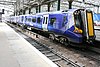
High Street railway station is located on High Street, on the North Clyde Line. The lands around the station have been developed into a hotel, and another scheme called Seventeen Acres is awaiting funding. The railway station itself will be substantially remodelled if the Glasgow Crossrail scheme is approved by the Scottish Government.
References[]
- ^ "Mural Trail: St. Mungo". www.citycentremuraltrail.co.uk. Retrieved 10 March 2019.
- ^ Loney, Gillian (3 June 2016). "Is Glasgow's historic High Street being left to ruin?". glasgowlive. Retrieved 11 July 2017.
- ^ Keay, John; Julia, Julia, eds. (1994). Collins Encyclopaedia of Scotland (9th ed.). London: HarperCollins. p. 448. ISBN 0002550822.
- ^ "Glasgow, High Street, Old College". canmore.org.uk. Retrieved 11 July 2017.
- ^ Old College (Mitchell Library, Glasgow Collection, late 1660s), The Glasgow Story
- ^ Old College (Mitchell Library, Joseph Swan, 1821), The Glasgow Story
- ^ High Street, 1900 (Mitchell Library, Glasgow Collection, Postcards Collection), the Glasgow Story
- ^ "TheGlasgowStory: College Goods Station". The Glasgow Story. Retrieved 11 July 2017.
- ^ High Street Goods, RailScot
- ^ Glasgow, 208 High Street, High Street Goods Station, Canmore
- ^ a b "New Collegelands business and residential site to open in city centre". STV News. 2 February 2012. Retrieved 11 July 2017.
- ^ Collegelands office scheme opens its doors, Urban Realm, 2 February 2012
- ^ Glasgow’s oldest street will be desecrated, its built heritage disfigured, The Guardian, 10 March 2018
External links[]
![]() Media related to High Street, Glasgow at Wikimedia Commons
Media related to High Street, Glasgow at Wikimedia Commons
Coordinates: 55°51′32″N 4°14′30″W / 55.85881°N 4.24174°W
This Glasgow location article is a stub. You can help Wikipedia by . |
- Streets in Glasgow
- History of Glasgow
- Glasgow geography stubs