Hirao
Hirao
平生町 | |
|---|---|
Town | |
 Hirao town hall viewed from Mt Iwaki | |
 Flag | |
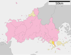 Location of Hirao in Yamaguchi Prefecture | |
 Hirao Location in Japan | |
| Coordinates: 33°56′N 132°04′E / 33.933°N 132.067°ECoordinates: 33°56′N 132°04′E / 33.933°N 132.067°E | |
| Country | Japan |
| Region | Chūgoku San'yō |
| Prefecture | Yamaguchi Prefecture |
| District | Kumage |
| Government | |
| • Mayor | Kunihiro Asamoto |
| Area | |
| • Total | 34.40 km2 (13.28 sq mi) |
| Population (October 1, 2016) | |
| • Total | 12,643 |
| • Density | 370/km2 (950/sq mi) |
| Time zone | UTC+09:00 (JST) |
| Website | www |

Hirao (平生町, Hirao-chō) is a town located in Kumage District, Yamaguchi Prefecture, Japan.
As of 2016, the town has an estimated population of 12,643 and a density of 370 inhabitants per square kilometre (958.30/sq mi). The total area is 34.40 km2 (13.28 sq mi).
Geography[]
Neighbouring municipalities[]
Transportation[]
Hirao did not have any train stations, with the Yanai station being the closest from the town and takes about a ten-minute travel from the town. Japan National Route 188 passes through Hirao.
External links[]
 Media related to Hirao, Yamaguchi at Wikimedia Commons
- Hirao official website (in Japanese)
| show Authority control |
|---|
This article about a location in Yamaguchi Prefecture is a stub. You can help Wikipedia by . |
Categories:
- Towns in Yamaguchi Prefecture
- Yamaguchi geography stubs